keithGA
Member
I'd say so.12z Euro soundings are high end for Friday across the northern half of GA into SC, especially around 21z.
Follow along with the video below to see how to install our site as a web app on your home screen.
Note: This feature may not be available in some browsers.
I'd say so.12z Euro soundings are high end for Friday across the northern half of GA into SC, especially around 21z.
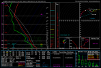
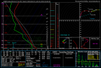
Lovely.Area averaged sounding over the GA/SC border from the Euro at 21z Friday.
Area averaged sounding over the GA/SC border from the Euro at 21z Friday.
I'm guessing models are starting to lean towards less occlusion for the Georgia threat now? Haven't checked it in A whileWhen the area-averaged sounding trips the PDS TOR, that ain't good...
Iirc it wasn't strongly modelled in the first place but is a possibility when compared to historical precedent for similar systems.I'm guessing models are starting to lean towards less occlusion for the Georgia threat now? Haven't checked it in A while
A mix of nocturnal and day I think. And I wouldn't characterize this event as a tornado outbreak. More so a severe outbreak with some tornadoes that could be strong.As of now, does today's threat look like it's going to be completely nocturnal? Also, is it mostly just hail or is a tornado outbreak still a sizable concern?
Haven’t heard about E AL/ W GA lately, so I am hoping that is good news? Seems like the bigger threat is further north.12z Euro soundings are high end for Friday across the northern half of GA into SC, especially around 21z.
I'm more worried about us getting hailers out of this system in Central Texas more than having tornadoes. We are entering that time of year that we are susceptible to those types of stormsThere is a lot of early morning convection tomorrow on the NSSL and HRRR simulated reflectivity south of Dallas to Waco, TX with the look to move off to the northeast towards the moderate risk area. I am curious of this cloud/precip to hurt instability further north and perhaps shift the greater risk south and possibly act as a trigger for discrete storms. New runs will be of interest.