• Welcome to TalkWeather!
    We see you lurking around TalkWeather! Take the extra step and join us today to view attachments, see less ads and maybe even join the discussion.
    CLICK TO JOIN TALKWEATHER

Severe WX Severe Weather Threat - February 22-23, 2023 (MO, IL, IN)

Timhsv

Member
Messages
410
Reaction score
684
Location
Meridianville, AL.
Special Affiliations
  1. SKYWARN® Volunteer
500hv.us_ov.png

Want to know what's nasty? This is nasty. 50-55 units of vorticity at 500mb with a bowling ball type of shortwave trof going negative.
Plenty of time to watch of coarse.
 

UK_EF4

Member
Messages
548
Reaction score
1,216
Location
NW London
One of the only ways I can describe the latest GFS runs is probably being wacky: Some of the hodographs are so large its almost comical, the surface wind field looks incredibly weird with really tight isobars in a small area as a result of the rapid deepening from strong diffluence of the shortwave, the thermodynamics look pretty unusual for Dixie as well with higher dew point depressions and very strong low level lapse rates - that being said, it is relatively concerning also.
gfs_2023021700_138_area_32.55-33.69.-89.37--88.06.png

ECM and UKMET concern me slightly more though with large warm sectors and strong shear in more of your typical tornado outbreak form - though just because something isn't typical or textbook does not mean its not dangerous!
sfctd_b-imp.conus.png

I am interested to see how the trough trends, as we saw with the past event the trough trended to be less amplified as we got closer, yet the compact negatively tilted nature of this trough makes me think it may not be the case here? I'm not sure, I'm not really an expert on how these different troughs trend closer to an event. And as I just said, the compact and complex nature of the trough though does make me think there could be heightened variability as models try resolving the feature, and small differences in the timing of the trough ejection could well make or break the event - something that could only be clear 2-3 days in advance!

I imagine the ceiling would be quite high for this event - yet also I fear the floor may not be that low either: while it could be too early to say I think that potentially we could have a dangerous strongly sheared QLCS (which we know can produce many tornadoes!) regardless of discrete supercells.
 

UncleJuJu98

Member
100,000th Post
Messages
3,863
Reaction score
4,963
Location
Birmingham
Unless there's enough instability these storms might just get sheared apart.

Forecast theta is pretty darn high so instability may currently be under forecast
 

UncleJuJu98

Member
100,000th Post
Messages
3,863
Reaction score
4,963
Location
Birmingham
Supercells composite is very high for a global, like I mentioned in the previous thread usually when I see orange and red widespread, a bad weather day could be on its way. Still 5 days away. As we know day 4/5 range can be a bit funky.

Seems like the euro is not on board with the GFS solution. I don't even think the ensemble's are completely on board with a upper low coming near the southeast.
 
Last edited:

UK_EF4

Member
Messages
548
Reaction score
1,216
Location
NW London
Supercells composite is very high for a global, like I mentioned in the previous thread usually when I see orange and red widespread, a bad weather day could be on its way. Still 5 days away. As we know day 4/5 range can be a bit funky.

Seems like the euro is not on board with the GFS solution. I don't even think the ensemble's are completely on board with a upper low coming near the southeast.
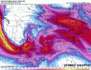
All the operational runs of global models agree on a shortwave trough moving through on Wednesday. I would argue UKMET and ECM are even more favourably timed than GFS as well. Ensembles seem about 65/35 yes/no but the mean brings the 60F dew point line into N AL MS on both EPS and GEFS, with an average of 45kt 850mb winds. These shortwaves are smaller and fast moving so naturally harder to forecast especially for global models, so I agree with you that best thing to do is watch the trends.
 

Attachments

  • models-2023021700-f138.500wh.conus.gif
    models-2023021700-f138.500wh.conus.gif
    996.3 KB · Views: 0

mattdanielwx

Member
Meteorologist
Messages
20
Reaction score
58
Location
Birmingham, AL
Next week's weather pattern is very uncertain at this point. European on a different page than the GFS. I'll say the 0z and 6z GFS runs are alarming for the Southeast. Plenty of instability and the wind shear is extremely high thanks to a negatively tilted trough and a low nearby at 992 mb. Euro has the system farther west with a stronger ridge for the Southeast. It's likely why the SPC isn't biting on this quite yet. You always have to watch the pattern when temperatures climb 10-20 degrees above average. 80s in February is very unusual and normally results in severe weather at some point.
 

UncleJuJu98

Member
100,000th Post
Messages
3,863
Reaction score
4,963
Location
Birmingham
Next week's weather pattern is very uncertain at this point. European on a different page than the GFS. I'll say the 0z and 6z GFS runs are alarming for the Southeast. Plenty of instability and the wind shear is extremely high thanks to a negatively tilted trough and a low nearby at 992 mb. Euro has the system farther west with a stronger ridge for the Southeast. It's likely why the SPC isn't biting on this quite yet. You always have to watch the pattern when temperatures climb 10-20 degrees above average. 80s in February is very unusual and normally results in severe weather at some point.
Good post, you work with WBRC FOX 6? correct? This weather site has a lot of meteorlgists. Always helps to keep us weather amateurs grounded lol.
 

UncleJuJu98

Member
100,000th Post
Messages
3,863
Reaction score
4,963
Location
Birmingham
12z operational GFS run still supporting the idea of a deep 500mb low going negative tilt across the southeast.

It seems like the ensemble's of the GFS have trended a tiny bit weaker on the ridge and look to atleast have a little wave run through the trough.

Still far away from a conclusive severe threat or significant severe threat. I'd like to see some general consensus of a upper level low swinging near the southeast for that.

I can't remember how trends where around the day 6-7 timeframe but we are in the funky 4-5 (if like to trademark that haha.) As we saw the last event some Significant changes in the synoptic scale will possibly occur as we move out of this time frame, so a general eye on model trends is important.
 
Back
Top