TornadoFan
Member
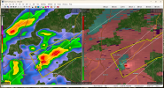
They should really warn that Union Springs storm.
Follow along with the video below to see how to install our site as a web app on your home screen.
Note: This feature may not be available in some browsers.

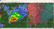
BULLETIN - EAS ACTIVATION REQUESTED
Tornado Warning
National Weather Service Lincoln IL
352 PM CST Tue Jan 3 2023
The National Weather Service in Lincoln has issued a
* Tornado Warning for...
Southeastern Logan County in central Illinois...
Eastern Sangamon County in central Illinois...
West central Macon County in central Illinois...
* Until 415 PM CST.
* At 352 PM CST, a confirmed tornado was located over mainly rural
areas of Sangamon and Logan Counties, moving northeast at 30 mph.
HAZARD...Damaging tornado.
SOURCE...Weather spotters confirmed tornado.
IMPACT...Flying debris will be dangerous to those caught without
shelter. Mobile homes will be damaged or destroyed.
Damage to roofs, windows, and vehicles will occur. Tree
damage is likely.
* The tornado will be near...
Latham around 410 PM CST.
Other locations in the path of this tornadic thunderstorm include
Warrensburg.
PRECAUTIONARY/PREPAREDNESS ACTIONS...
To repeat, a tornado is on the ground. TAKE COVER NOW! Move to a
basement or an interior room on the lowest floor of a sturdy
building. Avoid windows. If you are outdoors, in a mobile home, or in
a vehicle, move to the closest substantial shelter and protect
yourself from flying debris.
Unexpected TORR all the way up in IL.


They finally put a... *squints* SVR on the Union Springs storm.

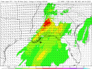
Looking healthy. Modelling continues to suggest atmosphere recovers tonight (though this definitely isn't how it usually goes over down here).Storms kicking off in Louisiana and Mississippi, this is your round two.
Shear will be higher considering it'll be dark, may end up having more activity with this one than the one right now. Cape will still be around 1000-1500 which is pretty goodLooking healthy. Modelling continues to suggest atmosphere recovers tonight (though this definitely isn't how it usually goes over down here).
I'll say this much, late-night linear setups with a hidden cyclonic surprise are perhaps my least favorite.Tbh paremeters for the final wave tonight are a good chunk higher than the current afternoon wave right now lol. Atleast for central Alabama. Maybe more linear though 
been hit by two when I lived in center point Alabama. 2 years ago and 10 years ago both ef3s lol. Both in the middle of the night so I know how ya feel.I'll say this much, late-night linear setups with a hidden cyclonic surprise are perhaps my least favorite.
Dang, sorry to hear that. Glad you're still here.been hit by two when I lived in center point Alabama. 2 years ago and 10 years ago both ef3s lol. Both in the middle of the night so I know how ya feel.