
At this point, I'm pretty much convinced that Joplin was pretty much a Hackleburg-Phil Campbell level tornado impacting a densely populated area. It's tough to find tornado damage in urban/suburban areas that eclipses that level of severity, except for maybe Moore 2013. Just insane.Another Joplin post? Yes.
I know some of these photos have been posted before, but I can't help but mention/analyze them again.
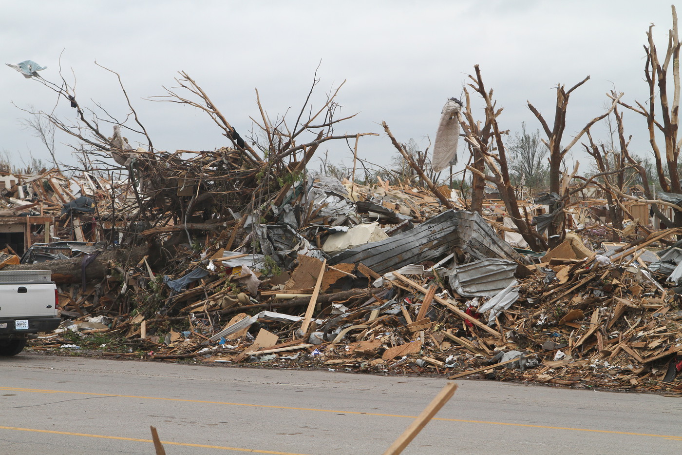
We all know Joplin was able to uproot and toss concrete parking stops, especially in the area around St. John's Regional Medical Center. This one traveled 20 m, and I started to wonder if maybe the tornado was capable of more than just tossing them...
View attachment 12923
Then pohnpei posted this photo.
View attachment 12927
Now, I don't know if this is from cleanup or perhaps a vehicle impact? If it was exclusively from the winds/flying debris, just WHAT kind of winds does it take to do this?
The tornado encountered an industrial area (very close to where the infamous Fastrip video was filmed) near the end of its second peak in intensity. The damage that Holly Springs caused to a shipping container was impressive, but Joplin was on another level, actually tearing them to pieces:
View attachment 12928
Some closeups of the three story apartment complex that was devastated:

Navigation
Install the app
How to install the app on iOS
Follow along with the video below to see how to install our site as a web app on your home screen.
Note: This feature may not be available in some browsers.
More options
-
Welcome to TalkWeather! We see you lurking around TalkWeather! Take the extra step and join us today to view attachments, see less ads and maybe even join the discussion. CLICK TO JOIN TALKWEATHER
You are using an out of date browser. It may not display this or other websites correctly.
You should upgrade or use an alternative browser.
You should upgrade or use an alternative browser.
Significant Tornado Events
- Thread starter locomusic01
- Start date
Juliett Bravo Kilo
Member
Moore slightly edges out Joplin in terms of ground scouring but it and Joplin are neck and neck in most other categories; vehicle damage, pavement scouring, destruction of hospitals, tall office buildings, tree debarking, low lying vegetation being shredded, etc.At this point, I'm pretty much convinced that Joplin was pretty much a Hackleburg-Phil Campbell level tornado impacting a densely populated area. It's tough to find tornado damage in urban/suburban areas that eclipses that level of severity, except for maybe Moore 2013. Just insane.
Juliett Bravo Kilo
Member
Those shipping containers....dear God.Another Joplin post? Yes.
I know some of these photos have been posted before, but I can't help but mention/analyze them again.
We all know Joplin was able to uproot and toss concrete parking stops, especially in the area around St. John's Regional Medical Center. This one traveled 20 m, and I started to wonder if maybe the tornado was capable of more than just tossing them...
View attachment 12923
Then pohnpei posted this photo.
View attachment 12927
Now, I don't know if this is from cleanup or perhaps a vehicle impact? If it was exclusively from the winds/flying debris, just WHAT kind of winds does it take to do this?
The tornado encountered an industrial area (very close to where the infamous Fastrip video was filmed) near the end of its second peak in intensity. The damage that Holly Springs caused to a shipping container was impressive, but Joplin was on another level, actually tearing them to pieces:
View attachment 12928
Some closeups of the three story apartment complex that was devastated:
Also, I think Moore 2013 or Vilonia might have torn some shipping containers apart, or turned a large metal tank inside out.
Juliett Bravo Kilo
Member
Another Joplin post? Yes.
I know some of these photos have been posted before, but I can't help but mention/analyze them again.
We all know Joplin was able to uproot and toss concrete parking stops, especially in the area around St. John's Regional Medical Center. This one traveled 20 m, and I started to wonder if maybe the tornado was capable of more than just tossing them...
View attachment 12923
Then pohnpei posted this photo.
View attachment 12927
Now, I don't know if this is from cleanup or perhaps a vehicle impact? If it was exclusively from the winds/flying debris, just WHAT kind of winds does it take to do this?
The tornado encountered an industrial area (very close to where the infamous Fastrip video was filmed) near the end of its second peak in intensity. The damage that Holly Springs caused to a shipping container was impressive, but Joplin was on another level, actually tearing them to pieces:
View attachment 12928
Some closeups of the three story apartment complex that was devastated:
I highly recommend this article:

Images Detailing EF5 Damage from the Joplin Tornado
□ Despite being the deadliest and most destructive tornado in recent history, the Joplin tornado’s awesome strength is sometimes overlooked. A google search of “Joplin tornado damage…
 extremeplanet.wordpress.com
Two pics of note:
Extreme surface winds partially scoured fields of grass behind Pizza Hut, where five people were killed after taking shelter in a walk-in freezer. The inner core of the tornado skirted between Home Depot and Walmart, but both stores likely experienced EF4+ winds as suction vortices rotated around the center of the storm. Eight people were killed in Home Depot, and three at Walmart.

Just east of Rangeline Road, warehouses were left as bare slabs, and large industrial vehicles were hurled more than 400 yards. At far right, the tornado left a trail of scoured vegetation and pronounced wind rowing.

MNTornadoGuy
Member
This might have been posted before but either way this photo of damage from Vilonia 2014 shows some high-end vegetation damage. There appears to be ground scouring in the foreground while small trees and shrubbery are shredded and debarked. It reminds me of vegetation damage from the two Moore F/EF5s and El Reno 2011 a bit.
This might have been posted before but either way this photo of damage from Vilonia 2014 shows some high-end vegetation damage. There appears to be ground scouring in the foreground while small trees and shrubbery are shredded and debarked. It reminds me of vegetation damage from the two Moore F/EF5s and El Reno 2011 a bit.
Other users have already alluded to this, but it's become apparent that Vilonia produced some of the most intense tornado damage ever photographed. I'd say it's absolutely comparable to the examples you mentioned.


Juliett Bravo Kilo
Member
Three tornados wrapped bike around trees
2003 Franklin Ks
View attachment 12936
2011 Philadelphia Ms
View attachment 12938
2013 Carney Ok
View attachment 12937
First time I've seen stuff like this, actually. I guess bicycles being wrapped around trees isn't as notable as large automobiles being wrapped/speared into them.
Also, 2003 Franklin, KS: this thing was so violent and should've been given an F5 rating.
MNTornadoGuy
Member
September 21 1894 was the second-worst September tornado outbreak in US history and one of the most violent in Iowa history. This outbreak was localized as it mostly occurred along or close to a warm front that stretched along the MN-IA border. At least 12 tornadoes (or 18) occurred, 4 of which (or several) were violent. At least 64 people were killed though the death total could be higher.

Tornado (Violent) #1 - Kossuth County IA F5:
This extremely violent and massive tornado touched down 3 miles north of Whittemore and would begin to cut a path of destruction across Kossuck, Hancock, Winnebago, and Faribault Counties. The twister leveled farm after farm as it ripped through rural areas north of Algona. At least five farms were completely swept away in Kossuth County with groves of trees being shredded, and debris being carried over a mile, including a wagon wheel which was reportedly carried 4 miles. ≥13 people were killed in Kossuck County alone. The tornado then suddenly turned sharply to the NE as it exited Kossuck County and cut across NW Hancock County doing an unknown amount of damage there. The devastation would continue in Winnebago County as at least 3 farms were swept away and splinters were driven into the ground. Farm machinery was "torn into pieces" at multiple farms. One woman was killed in this county as her home east of Buffalo Center was completely swept away. Then the tornado crossed the MN border into Faribault County where it would still produce violent damage. A "finely improved" farm 1 mile from the Iowa border was "completely swept out of existence" though thankfully the family there only had minor injuries. Not much else is available about the extent of damage in Minnesota though one newspaper in Freeborn County reported a person was killed though they could also be talking about the woman in Winnebago. The tornado dissipated 3 miles NW of Kiester. Like most of the major tornadoes from this event, this might have been a tornado family.
Tornado (Violent) #2 - Hancock County IA F4:
A killer and violent tornado would touch down 2 miles north of Wesley and move NE. Four miles NE of Wesley, the tornado would claim its first two victims in a farmhouse that was leveled. It then ripped through two farms owned by members of the Tweed family in Hancock or Kossuck County. These two farms were devastated with all buildings being leveled and a nearby schoolhouse was "swept out of existence." 4 people were killed on these farms. After leveling another house, there was reportedly a break in the path which might signal the formation of a new tornado. The damage path then re-developed north of Britt and the destruction continued. The scene along the tornado's path was just absolute desolation with >15 farms "losing everything" most likely being leveled. At least two of these farms were swept away. Thick oak trees were snapped off, debris was carried for over a mile with timbers being impaled in the ground, and a pump was pulled out of a well. 14 people were killed in Hancock County alone. The tornado then crossed into Cerro Gordo County where an unknown amount of damage was done (this is because the newspaper archive site for the county doesn't work.) Next was Worth County where the tornado almost immediately struck and completely swept away a "neat" but small house, killing three people. One of the dead was reportedly carried a half-mile. The storm then tore a devastating path through 10 miles of Worth County. Multiple farms were leveled, and I will give a description of what happened to a few of these farms. The first farm was the James O'Neil place which lost all buildings including the house which was blown 55 yards and smashed into kindling wood. "Everything about the foundation was blown 'slick and clean,' not an article being left within 27-33 yards." One was injured at the James O'Neil farm. The second place was the "great & fine" farm of David McKercher. The entire farm with "substantial, large, and modern buildings" was devastated with "debris being scattered over acres and the meadow, 220 yards away." At least one person was killed at this place. The tornado left a long blackened swath through cornfields as it uprooted and leveled the crops. A large fruit tree was reportedly carried a half-mile, an iron pump was ripped up along with 20 ft of pipe, and an arched span wrought iron bridge was destroyed. The tornado, still extremely violent, passed near Fertile. 5 farms were leveled or swept away in this area. At one of these farms, the "earth was literally torn up." The event finally ended 4 miles NE of Hantontown.
Tornado (Violent) #3 - Spring Valley MN F4:
A third violent event would begin 4 miles NE of Mason City and move through Cerro Gordo County. 3 people were killed in Cerro Gordo County but no details are available due to the same reason I mentioned above. It then crossed into Mitchell County where it produced violent damage. 13 farms were destroyed in this county (some possibly by the next event). 2-3 farms were leveled and 4 people were killed. The large tornado then moved into MN and struck the town of LeRoy. Multiple two-story buildings were destroyed, a blacksmith and home were reportedly "gone," a "fine and new residence" was demolished, and multiple homes were reportedly leveled. 4 people were killed. It continued moving NE, leveling multiple farms before cutting across the NW side of Spring Valley. Freight cars were thrown 44 yards and demolished, oil barrels were reportedly carried a mile, and 3 homes were "blown to pieces" with one being swept away. 5 people were killed here. The tornado then dissipated NE of town.
Tornado (Violent) #4 - Lowther IA F4:
This was the most poorly documented out of all the violent tornadoes. This event destroyed the small settlement of Lowther, reducing it to a "mass of bent timbers and splinters." The post office, stores, depot, and homes were destroyed in town. Thickly settled farmland was reportedly "devastated" with farms being destroyed. 5 people were killed.
Juliett Bravo Kilo
Member
The damage to the Dollar General is probably the worst I've ever seen to a steel-framed retail building (with the possible exception of the Niles Park Plaza being completely leveled and partially swept away by the 1985 Niles-Wheatland tornado).Alright, it's time for Part Three. The tornado reached extreme intensity, well beyond the EF5 range as it began to rip through subdivisions southwest of Vilonia. Although the EF4+ damage contour of the tornado at this stage was not wide, it was very well-defined and extremely dense. Crossing the path of the 2014 Tornado, the tornado struck several homes along Cody Drive, leaving nothing behind but bare slabs from most of them. Two young boys lost their lives here and their parents were seriously injured. The Damage Assessment Toolkit stated that cars were thrown over 100 yards away from these homes. The ground nearby was also scoured. A home just northeast of here was also completely slabbed and wind-rowed a long distance away.
A side view of the homes along Cody Lane. The home where the boys perished is third from top. Notice how all the debris is wind-rowed and tossed far away, indicative of an extremely high-end tornado.
View attachment 12911
An aerial view of the slabbed home just northeast of Cody Lane
View attachment 12912
Four homes were destroyed along Rocky Point road before the tornado crossed a highway at maximum strength, slabbing two more homes just north of the highway. A mid-aged woman was killed in one of these homes.
An aerial of the homes just north of the highway. The woman perished in the slabbed home just to the right of the highway.
View attachment 12913
As the tornado bore down on Vilonia, it hit a newly built school, which was set to open that fall. Needless to say, it did not open on schedule. The tornado caused the outer-bearing walls to collapse inwards, causing major structural failure of the building. Tim Marshall said that the only safe place for students would have been inside the hallways. The tornado barely missed some baseball and sports fields northeast of the school, where debris was strewn all over the place.
The destroyed remains of the school northeast of Vilonia.
View attachment 12914
The tornado became extremely catastrophic in strength as it hit downtown Vilonia. On the southern end of Main Street, one of, at least according to Tim Marshall's damage survey of the event, most incredible feats of tornado damage occurred. A tank that weighed 30,000 pounds was thrown "1192 meters," which is equal to about 3,910 feet, before coming to a rest along the tornado centerline. A Dollar General on the south side of street was totally obliterated and nearly pulled off of its foundation completely. The Vilonia Shopping Center took a direct hit and was completely destroyed and structurally compromised. Trees nearby sustained complete debarking.
The Dollar General that was nearly pulled off of its foundation
View attachment 12915
The structurally comprised Vilonia Shopping Center
View attachment 12916
On the northern side of the road, a swath of particularly extreme tornado damage commenced. A car dealership was totally obliterated, and cars that were at the dealership at the time were thrown and strewn across a field northeast of there. Several homes were completely destroyed in this area as well, killing a couple in one of them. A restaurant located in the field was swept away with little trace and hasn't been rebuilt as of today. Major ground scouring and total debarking of all vegetation took place in the EF5 swath at this location.
Little was left of the car dealership after it sustained a direct hit from the tornado
View attachment 12917
Very little was left of the restaurant that was leveled.
View attachment 12918
The sons of the couple killed in downtown Vilonia standing near the destroyed home of their parents.
View attachment 12919
Northeast of here, the home of David Mallory was slabbed. Mr. Mallory was aware that the tornado was coming, as his brother had called him, but the tornado was just too strong. It left a clean foundation behind and tossed Mr. Mallory's prized 1950s Chevy a long distance into a tree, where it lay a useless scrap of iron. Major tree debarking and ground scouring occurred near Mr. Mallory's home as well.
The destroyed remains of Mr. Mallory's home
View attachment 12920
Unfortunately, I am only able to attach 10 files per post, so it looks like we will have to see part four. The damage that will be highlighted in part four will be of extraordinary severity and is among the most violent tornado damage I've ever seen.
MNTornadoGuy
Member
The May 1896 tornado outbreak sequence was one of the most interesting events in tornado history. It was an extremely deadly and violent 9 days of tornadic activity, with 501 fatalities and 9 violent tornadoes (3 of which were F5s.) What was likely one of the most violent tornadoes of the 1896 tornado outbreak sequence and of the 19th century was the Seneca KS F5.

Clay County to Mitchell County
On May 17, 1896, a funnel cloud would make contact with the ground 9 miles south of Clyde KS, and start making its way NE and eastward. It then cut across northern Clay County, producing damage to multiple farms. It is hard to tell which damage was produced by the "main" tornado as also in this same county, an F3 moved parallel to the main one. It then passed into Washington County where it is certain that the damage was produced by the main event. Multiple farm outbuildings and a log house were destroyed in the extreme SE section of the county. The storm then crossed the county line into Mitchell County. Several farmhouses were "demolished" in the SW corner of the county before it passed near Irving (the town hit by the infamous 1879 tornadoes) where a hotel was unroofed. Between Irving and Frankfort, multiple farms were destroyed and a swath of trees was mowed down in forested areas. Some of these farms were reportedly swept away. It then made a direct hit on the town of Frankfort and left a swath of destruction through the northern area of the town. 50 homes and two churches were damaged or destroyed including some of the "best residences in town" which were "razed to the ground." The tornado began to rapidly grow in both size and intensity after leaving Frankfort and a nearly continuous path of F3+ damage would start. In extreme eastern Marshall County: grain fields were swept "as bare as a floor" and 3 farms were leveled. One of these farms was swept away. The tornado then crossed into Nemaha County where it became extremely violent.
Nemaha County
The now-massive tornado began its destruction in Nemaha County. 8 farms were leveled or completely swept away near Baileyville. Trees were debarked and some of the homes swept away were apparently large and multi-story. The event then caused great devastation in Seneca. This town would suffer some of the worst loss of life out of all the settlements struck. At least 16 homes were leveled (some of these were made of brick or concrete) in Seneca, 9 of which were completely swept away. "Not a vestige remained" of these homes with debris being carried for miles. The Grand Opera House, a 5400 sq ft structure, was a "total wreck and laid flat on the ground." 6 people were killed. The monster tornado continued its swath of devastation, passing near Harris Creek and Oneida. 13 farms were leveled in this area, many of which were completely swept away. 6 people were reportedly killed near these locations. The massive tornado then passed by Deer Creek where more extreme damage occurred. Trees were debarked "down to the roots so that the stumps looked like a phalanx of soldiers in white uniforms." In an orchard, "it tore up the ground, leaving furrows a foot deep and 2-3 ft wide." The worst human loss of life near Deer Creek occurred when it leveled a large 2-story stone house, killing 3 when they were crushed by the heavy walls. Other farms were "swept as bare as a floor." The tornado then struck the town of Sabetha where it would produce severe damage. 11 homes were leveled or swept away throughout the town. 3 people were killed here. After leaving town, it crossed into Brown County.
Brown County KS - Richardson County NE
As the tornado ripped across western Brown County, the storm widened into a tornado-downburst complex, which included multiple tornadoes. The main event passed north of Morill. In this area, a church and multiple farms were destroyed, with several farms once again being completely swept away. Trees/hedges were debarked and uprooted. 3 people died near Morrill. The tornado then struck and cut a swath of destruction through the town of Reserve. At least 10 homes and businesses were leveled or swept away, trees were snapped off at their base, and a heavy iron safe was thrown 25 ft. 5 people were killed in this town. The tornado continued to the NE destroying more farms in NW Brown County before crossing into extreme SE Richardson County, Nebraska. The tornado finally dissipated south of Preston. However, a separate tornado likely developed and made a direct hit on southern Falls City. Here multiple homes were destroyed at likely F3 intensity. 4 people were killed in Nebraska either from the Falls City or Reserve tornado.
Damage Photos:
Awesome write up. Lots of damage details I wasn’t aware of.The May 1896 tornado outbreak sequence was one of the most interesting events in tornado history. It was an extremely deadly and violent 9 days of tornadic activity, with 501 fatalities and 9 violent tornadoes (3 of which were F5s.) What was likely one of the most violent tornadoes of the 1896 tornado outbreak sequence and of the 19th century was the Seneca KS F5.
View attachment 13124
Clay County to Mitchell County
On May 17, 1896, a funnel cloud would make contact with the ground 9 miles south of Clyde KS, and start making its way NE and eastward. It then cut across northern Clay County, producing damage to multiple farms. It is hard to tell which damage was produced by the "main" tornado as also in this same county, an F3 moved parallel to the main one. It then passed into Washington County where it is certain that the damage was produced by the main event. Multiple farm outbuildings and a log house were destroyed in the extreme SE section of the county. The storm then crossed the county line into Mitchell County. Several farmhouses were "demolished" in the SW corner of the county before it passed near Irving (the town hit by the infamous 1879 tornadoes) where a hotel was unroofed. Between Irving and Frankfort, multiple farms were destroyed and a swath of trees was mowed down in forested areas. Some of these farms were reportedly swept away. It then made a direct hit on the town of Frankfort and left a swath of destruction through the northern area of the town. 50 homes and two churches were damaged or destroyed including some of the "best residences in town" which were "razed to the ground." The tornado began to rapidly grow in both size and intensity after leaving Frankfort and a nearly continuous path of F3+ damage would start. In extreme eastern Marshall County: grain fields were swept "as bare as a floor" and 3 farms were leveled. One of these farms was swept away. The tornado then crossed into Nemaha County where it became extremely violent.
Nemaha County
The now-massive tornado began its destruction in Nemaha County. 8 farms were leveled or completely swept away near Baileyville. Trees were debarked and some of the homes swept away were apparently large and multi-story. The event then caused great devastation in Seneca. This town would suffer some of the worst loss of life out of all the settlements struck. At least 16 homes were leveled (some of these were made of brick or concrete) in Seneca, 9 of which were completely swept away. "Not a vestige remained" of these homes with debris being carried for miles. The Grand Opera House, a 5400 sq ft structure, was a "total wreck and laid flat on the ground." 6 people were killed. The monster tornado continued its swath of devastation, passing near Harris Creek and Oneida. 13 farms were leveled in this area, many of which were completely swept away. 6 people were reportedly killed near these locations. The massive tornado then passed by Deer Creek where more extreme damage occurred. Trees were debarked "down to the roots so that the stumps looked like a phalanx of soldiers in white uniforms." In an orchard, "it tore up the ground, leaving furrows a foot deep and 2-3 ft wide." The worst human loss of life near Deer Creek occurred when it leveled a large 2-story stone house, killing 3 when they were crushed by the heavy walls. Other farms were "swept as bare as a floor." The tornado then struck the town of Sabetha where it would produce severe damage. 11 homes were leveled or swept away throughout the town. 3 people were killed here. After leaving town, it crossed into Brown County.
Brown County KS - Richardson County NE
As the tornado ripped across western Brown County, the storm widened into a tornado-downburst complex, which included multiple tornadoes. The main event passed north of Morill. In this area, a church and multiple farms were destroyed, with several farms once again being completely swept away. Trees/hedges were debarked and uprooted. 3 people died near Morrill. The tornado then struck and cut a swath of destruction through the town of Reserve. At least 10 homes and businesses were leveled or swept away, trees were snapped off at their base, and a heavy iron safe was thrown 25 ft. 5 people were killed in this town. The tornado continued to the NE destroying more farms in NW Brown County before crossing into extreme SE Richardson County, Nebraska. The tornado finally dissipated south of Preston. However, a separate tornado likely developed and made a direct hit on southern Falls City. Here multiple homes were destroyed at likely F3 intensity. 4 people were killed in Nebraska either from the Falls City or Reserve tornado.
Damage Photos:
View attachment 13125
View attachment 13126
J-Rab
Member
Excellent. It is stuff like this that keeps me coming here. Well done.The May 1896 tornado outbreak sequence was one of the most interesting events in tornado history. It was an extremely deadly and violent 9 days of tornadic activity, with 501 fatalities and 9 violent tornadoes (3 of which were F5s.) What was likely one of the most violent tornadoes of the 1896 tornado outbreak sequence and of the 19th century was the Seneca KS F5.
View attachment 13124
Clay County to Mitchell County
On May 17, 1896, a funnel cloud would make contact with the ground 9 miles south of Clyde KS, and start making its way NE and eastward. It then cut across northern Clay County, producing damage to multiple farms. It is hard to tell which damage was produced by the "main" tornado as also in this same county, an F3 moved parallel to the main one. It then passed into Washington County where it is certain that the damage was produced by the main event. Multiple farm outbuildings and a log house were destroyed in the extreme SE section of the county. The storm then crossed the county line into Mitchell County. Several farmhouses were "demolished" in the SW corner of the county before it passed near Irving (the town hit by the infamous 1879 tornadoes) where a hotel was unroofed. Between Irving and Frankfort, multiple farms were destroyed and a swath of trees was mowed down in forested areas. Some of these farms were reportedly swept away. It then made a direct hit on the town of Frankfort and left a swath of destruction through the northern area of the town. 50 homes and two churches were damaged or destroyed including some of the "best residences in town" which were "razed to the ground." The tornado began to rapidly grow in both size and intensity after leaving Frankfort and a nearly continuous path of F3+ damage would start. In extreme eastern Marshall County: grain fields were swept "as bare as a floor" and 3 farms were leveled. One of these farms was swept away. The tornado then crossed into Nemaha County where it became extremely violent.
Nemaha County
The now-massive tornado began its destruction in Nemaha County. 8 farms were leveled or completely swept away near Baileyville. Trees were debarked and some of the homes swept away were apparently large and multi-story. The event then caused great devastation in Seneca. This town would suffer some of the worst loss of life out of all the settlements struck. At least 16 homes were leveled (some of these were made of brick or concrete) in Seneca, 9 of which were completely swept away. "Not a vestige remained" of these homes with debris being carried for miles. The Grand Opera House, a 5400 sq ft structure, was a "total wreck and laid flat on the ground." 6 people were killed. The monster tornado continued its swath of devastation, passing near Harris Creek and Oneida. 13 farms were leveled in this area, many of which were completely swept away. 6 people were reportedly killed near these locations. The massive tornado then passed by Deer Creek where more extreme damage occurred. Trees were debarked "down to the roots so that the stumps looked like a phalanx of soldiers in white uniforms." In an orchard, "it tore up the ground, leaving furrows a foot deep and 2-3 ft wide." The worst human loss of life near Deer Creek occurred when it leveled a large 2-story stone house, killing 3 when they were crushed by the heavy walls. Other farms were "swept as bare as a floor." The tornado then struck the town of Sabetha where it would produce severe damage. 11 homes were leveled or swept away throughout the town. 3 people were killed here. After leaving town, it crossed into Brown County.
Brown County KS - Richardson County NE
As the tornado ripped across western Brown County, the storm widened into a tornado-downburst complex, which included multiple tornadoes. The main event passed north of Morill. In this area, a church and multiple farms were destroyed, with several farms once again being completely swept away. Trees/hedges were debarked and uprooted. 3 people died near Morrill. The tornado then struck and cut a swath of destruction through the town of Reserve. At least 10 homes and businesses were leveled or swept away, trees were snapped off at their base, and a heavy iron safe was thrown 25 ft. 5 people were killed in this town. The tornado continued to the NE destroying more farms in NW Brown County before crossing into extreme SE Richardson County, Nebraska. The tornado finally dissipated south of Preston. However, a separate tornado likely developed and made a direct hit on southern Falls City. Here multiple homes were destroyed at likely F3 intensity. 4 people were killed in Nebraska either from the Falls City or Reserve tornado.
Damage Photos:
View attachment 13125
View attachment 13126
MNTornadoGuy
Member
The 3rd F5 from the 1896 tornado outbreak sequence was probably one of the most violent tornadoes of the 19th century. This massive and extremely violent tornado touched down 3 miles north of Holly and would cut a path of absolute devastation through Oakland & Lapeer Counties. In rural areas, the destruction was at some of its worst as "fine farmhouses were swept from their foundations, their scattered timbers being strewn for miles and miles," farms lost not only buildings but were "stripped of every vestige of vegetation," and whole groves of trees were flattened or "divested of every bit of bark and foliage, and left nude and gaunt." The first town this tornado would pass through or near was Ortonville, here numerous homes were leveled or completely swept away. 22 people died in this area with multiple deaths occurring in single homes. It then passed through Oakwood where it once again produced extreme damage. Multiple homes were swept away and "two giant oaks were lying on their sides; every vestige of bark and foliage removed as cleanly as though with an axe, and even the roots standing out clean out of the earth where they had been rolled from a hill half a mile away." 10 people died in Oakwood. Next it struck the small village of Thomas where a hotel "disappeared into kindling" and two stores/multiple large homes were completely leveled. 3 people died here. The monster tornado described as an "immense black cloud that rolled along the ground," then cut across northern Oxford township where trees were debarked "as if done with a knife," and homes were torn from their foundations and flung in many directions. Some buildings were completely swept away with no debris left. 4 died in North Oxford. The last settlement that was devastated by this event would be the village of Whigville in Lapeer County. The destruction here was especially complete as "of the eight houses and twelve barns in Whigville, not a vestige remains." 3 people died in this village. The event dissipated west of Dryden. This was the 2nd deadliest tornado in Michigan history with 47 deaths.


Juliett Bravo Kilo
Member
May 1896 was an incredible two weeks of tornadic activity, if only we had the technology then to fully track all of it (and more access to damage photographs).The 3rd F5 from the 1896 tornado outbreak sequence was probably one of the most violent tornadoes of the 19th century. This massive and extremely violent tornado touched down 3 miles north of Holly and would cut a path of absolute devastation through Oakland & Lapeer Counties. In rural areas, the destruction was at some of its worst as "fine farmhouses were swept from their foundations, their scattered timbers being strewn for miles and miles," farms lost not only buildings but were "stripped of every vestige of vegetation," and whole groves of trees were flattened or "divested of every bit of bark and foliage, and left nude and gaunt." The first town this tornado would pass through or near was Ortonville, here numerous homes were leveled or completely swept away. 22 people died in this area with multiple deaths occurring in single homes. It then passed through Oakwood where it once again produced extreme damage. Multiple homes were swept away and "two giant oaks were lying on their sides; every vestige of bark and foliage removed as cleanly as though with an axe, and even the roots standing out clean out of the earth where they had been rolled from a hill half a mile away." 10 people died in Oakwood. Next it struck the small village of Thomas where a hotel "disappeared into kindling" and two stores/multiple large homes were completely leveled. 3 people died here. The monster tornado described as an "immense black cloud that rolled along the ground," then cut across northern Oxford township where trees were debarked "as if done with a knife," and homes were torn from their foundations and flung in many directions. Some buildings were completely swept away with no debris left. 4 died in North Oxford. The last settlement that was devastated by this event would be the village of Whigville in Lapeer County. The destruction here was especially complete as "of the eight houses and twelve barns in Whigville, not a vestige remains." 3 people died in this village. The event dissipated west of Dryden. This was the 2nd deadliest tornado in Michigan history with 47 deaths.
View attachment 13132
View attachment 13133
View attachment 13134
View attachment 13135
This outbreak sequence also spawned the Sherman, TX tornado, easily one of the most intense ever recorded. My previous post on it:
Significant Tornado Events
A lot of newspapers had the same famous photo of damage in West Frankfort in altered versions but here's the most HD one I could find More West Frankfort Planks from obliterated homes lay across the ground outside of West Frankfort That's all that I managed to find from hours shifting...
I wish there was more photos available of the damage from it, as it definitely was a high-end F5.
CheeselandSkies
Member
This was one of the periods that weeklong setup in May 2019 was being compared to ahead of time; along with similar extended outbreak sequences in May 1995 and 2003. Obviously it fell far short of any of those, however 1896 was by far the most violent of the other three even accounting for potentially looser standards for retroactive ratings and lack of more detailed damage surveys.May 1896 was an incredible two weeks of tornadic activity, if only we had the technology then to fully track all of it (and more access to damage photographs).
This outbreak sequence also spawned the Sherman, TX tornado, easily one of the most intense ever recorded. My previous post on it:

Significant Tornado Events
A lot of newspapers had the same famous photo of damage in West Frankfort in altered versions but here's the most HD one I could find More West Frankfort Planks from obliterated homes lay across the ground outside of West Frankfort That's all that I managed to find from hours shifting...talkweather.com
I wish there was more photos available of the damage from it, as it definitely was a high-end F5.
Sent from my Pixel 4a using Tapatalk
Sherman was one of the most violent tornadoes in US history. Unfortunately, there just isn’t much photographic documentation of the event. Would be awesome if some more could be dug up.May 1896 was an incredible two weeks of tornadic activity, if only we had the technology then to fully track all of it (and more access to damage photographs).
This outbreak sequence also spawned the Sherman, TX tornado, easily one of the most intense ever recorded. My previous post on it:
Significant Tornado Events
A lot of newspapers had the same famous photo of damage in West Frankfort in altered versions but here's the most HD one I could find More West Frankfort Planks from obliterated homes lay across the ground outside of West Frankfort That's all that I managed to find from hours shifting...
I wish there was more photos available of the damage from it, as it definitely was a high-end F5.
Lake Martin EF4
Member
While we're on topic - how big was the Oakwood tornado? I know Sherman was at least 60 yards when it hit the town and Seneca was up to two miles wide, but what about Oakwood?
Juliett Bravo Kilo
Member
Sherman's interesting since it seems to have done most of its damage in its rope phase; I think quite a bit of tornadoes are actually at their most violent when they rope out (Elie, Manitoba and Union City, OK being other notable examples).Sherman was one of the most violent tornadoes in US history. Unfortunately, there just isn’t much photographic documentation of the event. Would be awesome if some more could be dug up.
Juliett Bravo Kilo
Member
I have a feeling someone is sitting on a bunch of photograph we'd all like to see.Sherman was one of the most violent tornadoes in US history. Unfortunately, there just isn’t much photographic documentation of the event. Would be awesome if some more could be dug up.
Also, this article had a photograph that is available online but the scanned B&W quality makes some of the details a bit hard to make out but here the brown coloring you can see what looks like severe tree/vegetation debarking/damage and possible ground scouring. Look near the lower left of the photo for what looks like disturbed mud/topsoil. Also, note the tiny bits of wood from I think a large home nearby.

Deadly Sherman tornado remembered 122 years later
On May 15, 1896, Sherman was making world news with one of the most devastating tornados ever recorded still to this day.
 www.kxii.com