
Navigation
Install the app
How to install the app on iOS
Follow along with the video below to see how to install our site as a web app on your home screen.
Note: This feature may not be available in some browsers.
More options
-
Welcome to TalkWeather! We see you lurking around TalkWeather! Take the extra step and join us today to view attachments, see less ads and maybe even join the discussion. CLICK TO JOIN TALKWEATHER
You are using an out of date browser. It may not display this or other websites correctly.
You should upgrade or use an alternative browser.
You should upgrade or use an alternative browser.
Severe WX March 29-30, 2022 Severe Event
- Thread starter DetectiveWX
- Start date
Now completely unwarned. 125mph return at 7600' from BMX.
Perhaps they might have some information that we don't that's basically keeping them from pulling the trigger?
BayouWeatherGeek
Member
MattPetrulli
Member
Curious to see if it can complete this cycle, turn right, and develop a long lasting significant tornado. It's a work in progress but just 2 short lasting tornadoes at the moment. as to become a little more discrete if this were to occur.New cycle imminent SW of Leakesville.
KevinH
Member
Not something you want to see
CheeselandSkies
Member
Not something you want to seeView attachment 13031
Check the radar more closely, Spann...
Edit: In fairness, that's south of their viewing area.
MattPetrulli
Member
Actually seems to be gusting out for the moment but it's something to watchCurious to see if it can complete this cycle, turn right, and develop a long lasting significant tornado. It's a work in progress but just 2 short lasting tornadoes at the moment. as to become a little more discrete if this were to occur.
Also seems like a tornado just went through Livingston, AL.
cincywx
Member
BULLETIN - EAS ACTIVATION REQUESTED
TORNADO WARNING
NATIONAL WEATHER SERVICE BIRMINGHAM AL
903 PM CDT WED MAR 30 2022
THE NATIONAL WEATHER SERVICE IN BIRMINGHAM HAS ISSUED A
* TORNADO WARNING FOR...
NORTHWESTERN TUSCALOOSA COUNTY IN WEST CENTRAL ALABAMA...
EAST CENTRAL PICKENS COUNTY IN WEST CENTRAL ALABAMA...
* UNTIL 945 PM CDT.
* AT 903 PM CDT, A SEVERE THUNDERSTORM CAPABLE OF PRODUCING A TORNADO
WAS LOCATED NEAR GORDO, MOVING NORTHEAST AT 50 MPH.
Update to this: Fire is now 1000 acres and 0% contained, evacuations are currently around a mile away from parkway in PF.To add to today's issues, major fire weather problems in eastern TN; wildfire getting out of control in Wears Valley just outside Pigeon Forge is triggering local evacuations already
View attachment 12971
Kragg
Member
IDK if that’s Montgomery or Bham, but it needs a warningCheck the radar more closely, Spann...
Edit: In fairness, that's south of their viewing area.
BULLETIN - EAS ACTIVATION REQUESTED
TORNADO WARNING
NATIONAL WEATHER SERVICE BIRMINGHAM AL
903 PM CDT WED MAR 30 2022
THE NATIONAL WEATHER SERVICE IN BIRMINGHAM HAS ISSUED A
* TORNADO WARNING FOR...
NORTHWESTERN TUSCALOOSA COUNTY IN WEST CENTRAL ALABAMA...
EAST CENTRAL PICKENS COUNTY IN WEST CENTRAL ALABAMA...
* UNTIL 945 PM CDT.
* AT 903 PM CDT, A SEVERE THUNDERSTORM CAPABLE OF PRODUCING A TORNADO
WAS LOCATED NEAR GORDO, MOVING NORTHEAST AT 50 MPH.
Apparently, it's not a true tornado outbreak until Tuscaloosa (either the city or the county) is involved...
cincywx
Member
thankfully this is for northwestern tuscaloosa county. of course, the storm to the sw of tuscaloosa should be monitored for now.Apparently, it's not a true tornado outbreak until Tuscaloosa (either the city or the county) is involved...
TornadoFan
Member
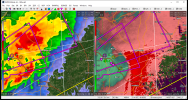
That Gordo storm is getting rather wrapped up.

akt1985
Member
The northern end of the line has slowed down considerably.
Kragg
Member
That big isolated cell outside of Citronelle has started to show more easterly movement the last couple of scans
Jetstream
Member
From a twitter report...Livingston Fire hearing trees snap and a roar