warneagle
Member
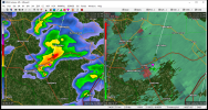
New watch for western AL and the northeast corner of MS.
Follow along with the video below to see how to install our site as a web app on your home screen.
Note: This feature may not be available in some browsers.
Only 45 minutes later and we’ve creeped up to 75/59 with a ton of sunshine.PWS near me is reading the same in Cullman
So far they haven't. I think they'll stay Mod cause of lingering uncertainties.I think SPC has set themselves up to go high risk.
When was the last PDS watch? I'm pretty sure last December's weren't either.Again the rather surprising decision not to use the PDS designation for a tornado watch covering a 15 hatched MDT.
Sent from my Pixel 4a using Tapatalk
And as an aside, if a high risk is anything less than an "outbreak of the decade" type event, or if the risk area placement isn't 100% spot on, then they always, without exception, catch a LOT of flak from angsty weather weenies screaming that it's a complete bust. I honestly don't blame them for not pulling the trigger on a high risk even for events like 4/12/20 and December 10.So far they haven't. I think they'll stay Mod cause of lingering uncertainties.
When was the last PDS watch? I'm pretty sure last December's weren't either.
New watch for western AL and the northeast corner of MS.