I don't think I've ever seen a TOR use a phrase such as "complete destruction is possible" before!
796
WFUS53 KPAH 110305
TORPAH
KYC083-157-110345-
/O.NEW.KPAH.TO.W.0036.211211T0305Z-211211T0345Z/
BULLETIN - EAS ACTIVATION REQUESTED
Tornado Warning
National Weather Service Paducah KY
905 PM CST Fri Dec 10 2021
The National Weather Service in Paducah has issued a
* Tornado Warning for...
Marshall County in western Kentucky...
Central Graves County in western Kentucky...
* Until 945 PM CST.
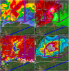
* At 904 PM CST, a confirmed large and extremely dangerous tornado
was located near Cayce, or near Clinton, moving northeast at 55
mph.
This is a PARTICULARLY DANGEROUS SITUATION. TAKE COVER NOW!
HAZARD...Damaging tornado.
SOURCE...Radar confirmed tornado.
IMPACT...You are in a life-threatening situation. Flying debris
may be deadly to those caught without shelter. Mobile
homes will be destroyed. Considerable damage to homes,
businesses, and vehicles is likely and complete
destruction is possible.
* The tornado will be near...
Mayfield around 930 PM CST.
Benton around 945 PM CST.
Other locations impacted by this tornadic thunderstorm include Fancy
Farm, Brewers, Symsonia, Wingo and Water Valley.
This includes the following highways...
Interstate 24 in Kentucky between Mile Markers 18 and 25.
Interstate 69 in Kentucky between Mile Markers 9 and 51.
PRECAUTIONARY/PREPAREDNESS ACTIONS...
To repeat, a large, extremely dangerous and potentially deadly
tornado is on the ground. To protect your life, TAKE COVER NOW! Move
to a basement or an interior room on the lowest floor of a sturdy
building. Avoid windows. If you are outdoors, in a mobile home, or in
a vehicle, move to the closest substantial shelter and protect
yourself from flying debris.
&&
LAT...LON 3679 8881 3694 8857 3694 8849 3699 8849
3705 8839 3682 8820 3675 8835 3675 8848
3669 8849 3654 8881
TIME...MOT...LOC 0304Z 236DEG 46KT 3659 8898
TORNADO...OBSERVED
TORNADO DAMAGE THREAT...CONSIDERABLE
MAX HAIL SIZE...2.50 IN
$$
PS