
weunice
Member
Heflin, population 245.
Follow along with the video below to see how to install our site as a web app on your home screen.
Note: This feature may not be available in some browsers.
Those storms cranking up north of Demopolis look like they are blowing up pretty fast. I'm guessing it's the warm front interaction?
Thanks...I figured as much...just wanted to confirm.Yeah they are associated the warm front. They are elevated and north of the warm front.


Those are shear values that are reminiscent of a certain day. Almost 9 years ago.Just southwest of Birmingham. The surface SRH is nuts.
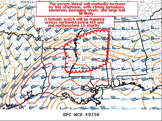
View attachment 2792
Nope, don't like that.Those are shear values that are reminiscent of a certain day. Almost 9 years ago.
Yep. I’d go high along and just north of 20/59 from just East of Jackson to about Gadsden.I really don't see how that can't go high risk for some areas
Yeah, I think they have to pull the trigger. The HRRR isn't the only model progging off-the-charts shear values. I'd say roughly between 55 and 65 and north of 20/US-80.I really don't see how that can't go high risk for some areas
I'm in N AL and SO not looking forward to any of this. My nerves are already shot.Personally I’m not crazy about a squall line producing tornadoes. At least you can get out of the way of a supercell. Squall lines you just have to hunker down and hope it doesn’t spin one up on top of you. Based on models that tornado producing line will end up over North Alabama by this afternoon/evening.