• Welcome to TalkWeather!
    We see you lurking around TalkWeather! Take the extra step and join us today to view attachments, see less ads and maybe even join the discussion.
    CLICK TO JOIN TALKWEATHER

Severe Weather 2026

I'm just referring to the small trough that crosses the Rockies in the majority of the models at about ~140 hours, then lifts north afterwards. That wave might help bring up some moisture for any storm system that comes in behind it, the latter of which being closer to what that post is talking about.
Heck if that primer actually boosts moisture in the southeast maybe Midwest plains prior to a monster long wave trough the gfs shows we are gunna be in some deep doody.
 
I'm just referring to the small trough that crosses the Rockies in the majority of the models at about ~140 hours, then lifts north afterwards. That wave might help bring up some moisture for any storm system that comes in behind it, the latter of which being closer to what that post is talking about.
Oh okay gotcha interesting
 
Heck if that primer actually boosts moisture in the southeast maybe Midwest plains prior to a monster long wave trough the gfs shows we are gunna be in some deep doody.
Sure, but I'd say that the likelihood of that actually coming to fruition as of now is very low. There's still plenty of model disagreement after that primer wave swings through. It's been a trend this year for troughs 8+ days out to degenerate into slop, and I wouldn't be surprised in the slightest if that happens in this case. All I'm saying at the moment is that there is agreement on some sort of "primer" wave now - I don't want to hype anything up too much at all, not yet.
 
Sure, but I'd say that the likelihood of that actually coming to fruition as of now is very low. There's still plenty of model disagreement after that primer wave swings through. It's been a trend this year for troughs 8+ days out to degenerate into slop, and I wouldn't be surprised in the slightest if that happens in this case. All I'm saying at the moment is that there is agreement on some sort of "primer" wave now - I don't want to hype anything up too much at all, not yet.
Haha, understand. I agree not time to hype. Although there is some ensemble support. We are still in voodoo land •_•
 
Last edited:
Sure, but I'd say that the likelihood of that actually coming to fruition as of now is very low. There's still plenty of model disagreement after that primer wave swings through. It's been a trend this year for troughs 8+ days out to degenerate into slop, and I wouldn't be surprised in the slightest if that happens in this case. All I'm saying at the moment is that there is agreement on some sort of "primer" wave now - I don't want to hype anything up too much at all, not yet.
We are just not in a good pattern for
Severe weather in the central plains and in the south
 

Yeah, i was struggling to confirm that was AI. AI would be a lot more telltale just visually but that seemed generally pretty accurate. Quite a surprise day in the east coast today. Regardless of the 5%, i can't say I expected too much out of it
 
I'll add my little tidbit in on that trough showing up in the long range that people have mentioned. While I know this second season hasn't been particularly active nor impressive, you must maintain level headed with signals like this and not get too ahead of yourself. If we are to analyse this and take it verbatim, what i would be thinking is:
Impressive flow aloft surges into portions of Louisiana with very obvious diffluence in W MS with strong ascent. Ascent is stronger up north where instability is lacking but shear is very impressive with 350-400 0-1km SRH here. Ascent does exist to a lesser degree down south in SE LA where I'd say this scenario would reasonably surge storms given no evident warm nose.

It's not really that impressive of a scenario when you really take a look at it, the shear is eye catching but rather meridional flow additionally over the warm sector in fact would probably make this 12z run reliant on confluence bands.

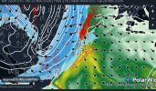
If you're a visual learner, here's what I'm trying to explain:
Screenshot_2026-11-12-22-58-37-591.jpeg
Credit to PolarWx for this very useful tool that shows you areas of ascent with the trough.

The more bold the red gets, consider that like stronger forcing and that area in W MS is extremely evident.

The 18z is pretty interesting to say the least. Centers the main svr threat over SE TX but definitely not as much of a potent shear environment. Trough would probably favor more of a semi clustered on this run, rather than meridional but still not exactly a great look for anything we maintained.

And diffluence aloft again is north of the best general environment. So should we throw this out in the bin? Not entirely. StormNet has had a broad signal for it and deterministics are also keying in on this timeframe. You have to watch how this southern jet evolves and if this signal even stays. There's a chance it will go, but it's worth a watch. The jet isn't particularly well timed on these runs but that can improve a lot over the span of a week. Don't get your heads in a swivel yet, just keep a little peek on it for now.
 
I'll add my little tidbit in on that trough showing up in the long range that people have mentioned. While I know this second season hasn't been particularly active nor impressive, you must maintain level headed with signals like this and not get too ahead of yourself. If we are to analyse this and take it verbatim, what i would be thinking is:
Impressive flow aloft surges into portions of Louisiana with very obvious diffluence in W MS with strong ascent. Ascent is stronger up north where instability is lacking but shear is very impressive with 350-400 0-1km SRH here. Ascent does exist to a lesser degree down south in SE LA where I'd say this scenario would reasonably surge storms given no evident warm nose.

It's not really that impressive of a scenario when you really take a look at it, the shear is eye catching but rather meridional flow additionally over the warm sector in fact would probably make this 12z run reliant on confluence bands.

If you're a visual learner, here's what I'm trying to explain:
View attachment 55565
Credit to PolarWx for this very useful tool that shows you areas of ascent with the trough.

The more bold the red gets, consider that like stronger forcing and that area in W MS is extremely evident.

The 18z is pretty interesting to say the least. Centers the main svr threat over SE TX but definitely not as much of a potent shear environment. Trough would probably favor more of a semi clustered on this run, rather than meridional but still not exactly a great look for anything we maintained.

And diffluence aloft again is north of the best general environment. So should we throw this out in the bin? Not entirely. StormNet has had a broad signal for it and deterministics are also keying in on this timeframe. You have to watch how this southern jet evolves and if this signal even stays. There's a chance it will go, but it's worth a watch. The jet isn't particularly well timed on these runs but that can improve a lot over the span of a week. Don't get your heads in a swivel yet, just keep a little peek on it for now.
Nice post!
 
The only two forecast models that have been showing a Thanksgiving week severe threat are the Euro and GFS. That being said, the consistency between the two isn't there yet. From a pattern perspective, yes, I do see the potential, but until we get more consistency, I'm going with a more heavy rain solution.
 
Back
Top