• Welcome to TalkWeather!
    We see you lurking around TalkWeather! Take the extra step and join us today to view attachments, see less ads and maybe even join the discussion.
    CLICK TO JOIN TALKWEATHER

Severe Weather 2026

As usual, it's set up just about an hour too far away and too conditional for a work day/night.
One scenario is a warm sector that is just full with WAA slop, and the other is a conditional scenario assuming moisture return improves and cells beat the strong warm nose. I'm not really confident on this one but we'll see anyways
 
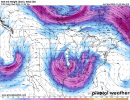
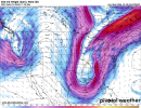
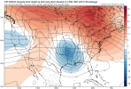
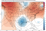
This would be the kind of situation where you start to get into the aforementioned Gulf-scraper territory. Still possible for some severe potential, especially on the eastern end, but there gets to be a point where your main disturbance is just too far south, and it's pretty common to see systems trend southward like this during the Fall season. Just for fun, take a look at that trough off the Euro! *chef's kiss*
floop-gfs-2026102806.500wh.conus.gif1793192710519.png
 
Per Spann this morning:

NEXT WEEK: Monday and Tuesday look generally dry with just a small risk of a shower both days. Then, a dynamic weather system arrives at mid-week with rain and thunderstorms late Wednesday into Thursday.
The amount of surface based instability is the big question; still too early to know if severe thunderstorms will be an issue, but it is certainly possible. Rain amounts of 1-2 inches are expected.

Still the only Birmingham met mentioning the possibility, at least online.
 
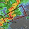
HRRR uptrended instability but the 300mb flow is very boundary parallel and the warm sector is very limited for any prefrontals to develop. If any, that's your best chance today. I am not confident in a sigtor today though regardless.
 
HRRR uptrended instability but the 300mb flow is very boundary parallel and the warm sector is very limited for any prefrontals to develop. If any, that's your best chance today. I am not confident in a sigtor today though regardless.
Sounds little messy leprechaun, when flow parallel boundary I just bout give up to chase
 
Sounds little messy leprechaun, when flow parallel boundary I just bout give up to chase
Usually, the best options are stuff that gets south of the boundary and doesn't get as messy. Models usually manage to forecast these parallel flow events well and they are saying a mess.
 
I think the euro and gfs and it's ensembles are starting to congeal on a bowling ball trough. My question now is how much moisture are we working with. There's also a little system a few days prior depending on it, seems to push moisture back into the gulf so that'll be something to watch. Im hesitant to say it..... but...

WE'RE BACK!
 
The Storm Prediction Center, on or about November 16, 2026 will begin issuing afternoon Day 4-8 Severe Weather Outlooks, at 2130 UTC (4:30 PM CDT/3:30 PM CST).

HVuQ4aAWwAAx_hU.png
 
The Storm Prediction Center, on or about November 16, 2026 will begin issuing afternoon Day 4-8 Severe Weather Outlooks, at 2130 UTC (4:30 PM CDT/3:30 PM CST).

View attachment 55412
Hopefully it won't make too much work for them, but this is a much-welcome addition for most of us storm geeks.
 
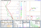
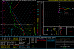
Warm nose Inversion at 675 Mb

dry air at 675 Mb

Skinny instability

poor lapse rates except on the skew t and

moisture plume the T and td aren’t really all that separated at 875 Mb but there’s some dry air at the surface but still adequate moisture at upper 50s and getting warm too with temperature being 67 degrees

srh looks good 160 at 0-1 km and 216 at 0-3 km wind shear at 0-1 km might be on the low side at 25 knots but could be enough for tornado mischief but better at 0-3 km at 36 knots effective inflow layer is quite low with srh and low knots the rest of the levels look good Hodograph has some curvature in low levels decent speed and directional shear in mid levels
 

Attachments

  • image.png
    image.png
    74.1 KB · Views: 8
Warm nose Inversion at 675 Mb

dry air at 675 Mb

Skinny instability

poor lapse rates except on the skew t and

moisture plume the T and td aren’t really all that separated at 875 Mb but there’s some dry air at the surface but still adequate moisture at upper 50s and getting warm too with temperature being 67 degrees

srh looks good 160 at 0-1 km and 216 at 0-3 km wind shear at 0-1 km might be on the low side at 25 knots but could be enough for tornado mischief but better at 0-3 km at 36 knots effective inflow layer is quite low with srh and low knots the rest of the levels look good Hodograph has some curvature in low levels decent speed and directional shear in mid levels
Nice analysis! Yeah, I'd say a proximity sounding would serve better in this case.
 
Back
Top