Kds86z
Member
Hey don't be a party pooper leprechaun, I need a reason so I can get back on the forum. And get out of the talkweather slumber I've been in from the quiet season lol. Lol hopefully we will know something better in about 2-3 days

Follow along with the video below to see how to install our site as a web app on your home screen.
Note: This feature may not be available in some browsers.
Hey don't be a party pooper leprechaun, I need a reason so I can get back on the forum. And get out of the talkweather slumber I've been in from the quiet season lol. Lol hopefully we will know something better in about 2-3 days


Yeah im not sure who is starting the hype train but my boss at work came up to me and said he's hearing people talking about a possible tornado outbreak in alabama in 10 days..... *face palm*

Yeah and this guy doesn't just hype things up. I haven't said anything to anybody. He just came up to me out of the blue hahaha


A brief rebound in shortwave ridging after the weekend system will lower rain chances until Tuesday, but can't rule out some rain in that time. The West Coast trough should break down over the weekend and the overall pattern become more progressive. A low pressure system deepening out of this trough is then expected to dig and spin over the Southern Plains early in the week. Timing and spacing of the features is uncertain for that kind of pattern this far out, but it will likely result in a stronger frontal system crossing the region. More robust guidance solutions support a cold front squall line scenario on Tuesday. Explicit instability values are low this far in advance, but greater moistening (dew points over 65) and flow resulting in better wind shear may bring a chance for more organized thunderstorm development or even severe weather to our area on Tuesday.

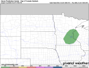
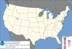
Well hello there tornado hatch, long time no see.. oh wait, maybe we did with Isaias. One last tornado hurrah for October."Veered wind profiles and strong deep-layer shear will support a discrete mode
including the potential for supercells. In fact, wind profiles are
quite favorable within this zone with instability being the primary
limiting factor. However, it would only take an increase of a few
degrees in the dewpoint and/or temperature for greater instability
and potentially a more impactful event. Therefore, while the
forecast remains conditional, the ceiling could involve strong
tornado potential."
Also new day 1 put 2-5% cig 1 hatched avocado
You’re up @CheeselandSkies, haha. Doubt you can though."Veered wind profiles and strong deep-layer shear will support a discrete mode
including the potential for supercells. In fact, wind profiles are
quite favorable within this zone with instability being the primary
limiting factor. However, it would only take an increase of a few
degrees in the dewpoint and/or temperature for greater instability
and potentially a more impactful event. Therefore, while the
forecast remains conditional, the ceiling could involve strong
tornado potential."
Also new day 1 put 2-5% cig 1 hatched avocado
Correct just fixing post that….Euro is leaning with the gfs solution now

You’re up @CheeselandSkies, haha. Doubt you can though.

As for this, tell him wheres he getting it from on Facebook. Pat DooDoo's Weather Page with the big, overzealous graphic made by a human called Alec Itty (read the initial) and it's got the text all over the place with weird graphics! Yeah, that's probably where. Facebook is a absolute travesty today as a result of this guy called Alec IttyYeah im not sure who is starting the hype train but my boss at work came up to me and said he's hearing people talking about a possible tornado outbreak in alabama in 10 days..... *face palm*