

Navigation
Install the app
How to install the app on iOS
Follow along with the video below to see how to install our site as a web app on your home screen.
Note: This feature may not be available in some browsers.
More options
-
Welcome to TalkWeather! We see you lurking around TalkWeather! Take the extra step and join us today to view attachments, see less ads and maybe even join the discussion. CLICK TO JOIN TALKWEATHER
You are using an out of date browser. It may not display this or other websites correctly.
You should upgrade or use an alternative browser.
You should upgrade or use an alternative browser.
Severe Weather 2026
- Thread starter KevinH
- Start date

Kds86z
Member
Kds86z
Member
This is wild yall… impressive tornado for a no risk. 2026..

 www.facebook.com
197K views · 2.7K reactions | Tornado near Fort Stockton, TX on Wednesday afternoon... ️ Victor Castillo | Meteorologist Conley Isom
Tornado near Fort Stockton, TX on Wednesday afternoon... ️ Victor Castillo
www.facebook.com
Attachments
Last edited:

Cyclonic Paracosm
Member
is today funny enough to warrant its own thread? or no

For a 2%? No.is today funny enough to warrant its own thread? or no
Even a 5% imo shouldn’t really warrant a thread with the exception of special circumstances

WeathermanLeprechaun
Member
This is wild yall… impressive tornado for a no risk. 2026..
197K views · 2.7K reactions | Tornado near Fort Stockton, TX on Wednesday afternoon... ️ Victor Castillo | Meteorologist Conley Isom
Tornado near Fort Stockton, TX on Wednesday afternoon... ️ Victor Castillo
Not to be a Debbie Downer but Fort Stockton is the place of mesoscale insanity a wizardry. This area is literally notorious for surprise sigtors in any measurable amount of instability. Doesn't surprise me.
WeathermanLeprechaun
Member
As to how it happened, I'd say strong LL SRW and a obvious nudger in the backside of the cell evident. Vertical stretching a terrain does it over here too
Prime example of why we will never accurately predict tornadoes. Variables like this works other times and sometimes they don't. That's why I love this hobby.
Prime example of why we will never accurately predict tornadoes. Variables like this works other times and sometimes they don't. That's why I love this hobby.
Kds86z
Member
Not a Debbie downer.Not to be a Debbie Downer but Fort Stockton is the place of mesoscale insanity a wizardry. This area is literally notorious for surprise sigtors in any measurable amount of instability. Doesn't surprise me.
 I have heard of fort Stockton shenanigans. It’s October and it just took me by surprise.
Last edited:
Kds86z
Member
I think it's more funny this is the first time no chaser has seen a Fort Stockton region tornado. Given how reliable the area has been the last few years.Not to be a Debbie Downer but Fort Stockton is the place of mesoscale insanity a wizardry. This area is literally notorious for surprise sigtors in any measurable amount of instability. Doesn't surprise me.
Anti-Freeze
Member
What's up with the hourly forecast section on weather.gov (NWS)? For several days now it has shown Little Rock, Tulsa, OKC, & DFW with temperatures flatlining hi/lows in the low 40's for Sat, Sun, and Mon, but the official forecast page has highs in the 60's and 70's all 3 days. It's been doing this since Tuesday.
I can't recall seeing such a huge mismatch like that before, certainly not uncorrected for several days.
I can't recall seeing such a huge mismatch like that before, certainly not uncorrected for several days.
WeathermanLeprechaun
Member
No chaser seen the other one in July either. These mesoscale tors are hard to predict but the basics were there yesterday for such..I think it's more funny this is the first time no chaser has seen a Fort Stockton region tornado. Given how reliable the area has been the last few years.
Kds86z
Member
WeathermanLeprechaun
Member
Tornado threat may conditionally continue in IL/IN now that updrafts have developed.
The next two hours are favorable for supercells, favorable for potentially weak tornadoes. Here is the 0-2km UH product via the new Satsquatch update which is absolutely fantastic for analysing the potential for rotating updrafts via the 12z HRRR which helps gets a good grip of the areas with most interest.
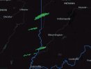
0-2km UH needs to be utilised a lot more in CAMS as it legitimately is the real, surface based UH you should be referencing to instead of 2-5km. This shows things pretty well should cells begin to mature but nothing too robust.
The next two hours are favorable for supercells, favorable for potentially weak tornadoes. Here is the 0-2km UH product via the new Satsquatch update which is absolutely fantastic for analysing the potential for rotating updrafts via the 12z HRRR which helps gets a good grip of the areas with most interest.
0-2km UH needs to be utilised a lot more in CAMS as it legitimately is the real, surface based UH you should be referencing to instead of 2-5km. This shows things pretty well should cells begin to mature but nothing too robust.
They're all lethargic as of now but they're all clearly supes. Think we might get a few tors out of these.Tornado threat may conditionally continue in IL/IN now that updrafts have developed.
The next two hours are favorable for supercells, favorable for potentially weak tornadoes. Here is the 0-2km UH product via the new Satsquatch update which is absolutely fantastic for analysing the potential for rotating updrafts via the 12z HRRR which helps gets a good grip of the areas with most interest.
View attachment 55324
0-2km UH needs to be utilised a lot more in CAMS as it legitimately is the real, surface based UH you should be referencing to instead of 2-5km. This shows things pretty well should cells begin to mature but nothing too robust.
Cyclonic Paracosm
Member
we got rotations up this line rn and a wall cloud report
Kds86z
Member
yep tornado possible tagBone Gap storm looks pretty impressive despite being huddled into a line.
Kds86z
Member
AT 544 PM CDT, A SEVERE THUNDERSTORM WAS LOCATED OVER
LAWRENCEVILLE, MOVING EAST AT 25 MPH.
HAZARD...60 MPH WIND GUSTS.
SOURCE...RADAR INDICATED.
IMPACT...EXPECT DAMAGE TO ROOFS, SIDING, AND TREES.
* THIS SEVERE THUNDERSTORM WILL BE NEAR...
LAWRENCEVILLE AND LAWRENCEVILLE VINCENNES AIRPORT AROUND 550 PM
CDT.
THIS ALSO INCLUDES RED HILLS STATE PARK.
PRECAUTIONARY/PREPAREDNESS ACTIONS...
REMAIN ALERT FOR A POSSIBLE TORNADO! TORNADOES CAN DEVELOP QUICKLY
FROM SEVERE THUNDERSTORMS. IF YOU SPOT A TORNADO GO AT ONCE INTO THE
BASEMENT OR SMALL CENTRAL ROOM IN A STURDY STRUCTURE.
LAWRENCEVILLE, MOVING EAST AT 25 MPH.
HAZARD...60 MPH WIND GUSTS.
SOURCE...RADAR INDICATED.
IMPACT...EXPECT DAMAGE TO ROOFS, SIDING, AND TREES.
* THIS SEVERE THUNDERSTORM WILL BE NEAR...
LAWRENCEVILLE AND LAWRENCEVILLE VINCENNES AIRPORT AROUND 550 PM
CDT.
THIS ALSO INCLUDES RED HILLS STATE PARK.
PRECAUTIONARY/PREPAREDNESS ACTIONS...
REMAIN ALERT FOR A POSSIBLE TORNADO! TORNADOES CAN DEVELOP QUICKLY
FROM SEVERE THUNDERSTORMS. IF YOU SPOT A TORNADO GO AT ONCE INTO THE
BASEMENT OR SMALL CENTRAL ROOM IN A STURDY STRUCTURE.
Cyclonic Paracosm
Member
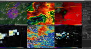
Can someone affirm if Lawrenceville is otg??