• Welcome to TalkWeather!
    We see you lurking around TalkWeather! Take the extra step and join us today to view attachments, see less ads and maybe even join the discussion.
    CLICK TO JOIN TALKWEATHER

Severe Weather Threat 09/14/2026 (SE Nebraska to Central Iowa)

Grand Poo Bah

Member
Sustaining Member
Messages
2,193
Reaction score
7,816
Location
Iowa
1789413378183.png

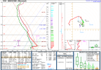
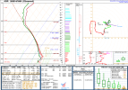
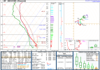
Starting a thread for today's severe weather threat, despite recent downtrends in the forecast, because today is still the highest tornado potential we've seen in a month and I think today's observed soundings reveal a potent (yet highly conditional) tornado environment. The ceiling is certainly high today.

1PM CDT Aberdeen, SD Sounding reveals almost 500 m2/s2 0-1km SRH
1789413608626.png


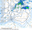
1 PM CDT Omaha, NE Sounding

1789413770123.png

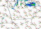
1PM CDT North Platte, NE Sounding reveals surface CAPE builds fast where clouds are clearing.
1789413947917.png

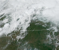
There's quite a bit of clearing with strong surface winds pushing dry air to the North
1789414134595.png

We'll see what happens!
 
Last edited:
"You have to be south of this front today for tornadoes." I mean, that's not uncommon, but the question is does anything actually go south of the front? Even if it does, deep layer shear is rather mediocre today in the warm sector and could lead to poor venting and rain-wrapped storms.

 
This thread had plenty of time imo to be made when it was first outlined by the SPC but not everyone has time to make threads

As for your comment regarding "there's not enough reliable data", the HRRR has consistently nailed this elevated convection aloft continuing to stunt the warm sector to a extent. It's a nowcasting day, sure but there's been models very consistent in this scenario of SW-NE junk that crosses north of the warm sector. The ceiling is there but it is quite literally nothing at the floor and it's dependant on this next 2-3 hours now honestly if we are to see anything happen. I get to be cautious but there is so much mediocrity synoptically and thermodynamically, it's just being brutally honest at what may happen. Agree to disagree absolutely, but i wouldn't be setting expectations high.
 
Based on current clearing and surface temps the main threat area looks like it could be south central Iowa to Des Moines. Temps are definitely climbing rapidly.

1789416608218.png1789416707743.png1789416954519.png
 
This thread had plenty of time imo to be made when it was first outlined by the SPC but not everyone has time to make threads

As for your comment regarding "there's not enough reliable data", the HRRR has consistently nailed this elevated convection aloft continuing to stunt the warm sector to a extent. It's a nowcasting day, sure but there's been models very consistent in this scenario of SW-NE junk that crosses north of the warm sector. The ceiling is there but it is quite literally nothing at the floor and it's dependant on this next 2-3 hours now honestly if we are to see anything happen. I get to be cautious but there is so much mediocrity synoptically and thermodynamically, it's just being brutally honest at what may happen. Agree to disagree absolutely, but i wouldn't be setting expectations high.

Oh I don't have high expectations at all. It's basically a coin flip right now. I was just pointing out that the system has basically been in a "blind spot" the last two days so to the short range model outputs weren't being fed great data. I agree the HRRR has been performing well for most of today so far.
 
Also, do not underestimate wind today. We had a 87 mph wind gust just there in Southern Nebraska. It's looking pretty unlikely we verify anything tornadic for now, but wind will pack a stronger punch than expected
 
This is your 5CIG1 warm sector atm... Nah. That's not cutting it. It'd be a miracle if anything happened within this stuff. Screenshot_2026-09-14-22-53-00-173.jpeg
 
Tornado watche just issued
Yeah, brief tor or two possible of course. I'm just talking sigtors. This is not a great look at all for tornadoes in general but we will see
 
there's your monthly slopvection setup. toa issued with 40/20 probs, could still see a brief tor or two.
Still don't really understand the tor watch either. The environment does support a brief tor, buy like svr watch would've also done given the major downtrends.

This was slop 7 days out, most of my comments on the setup just stem from frustration on why it was getting hyped too much. This is exactly what's hurts weather credibility when you take setups like these and spam "MAJOR STP, StormNet (good tool but I seen it being used wrongly too) UH, RRFS"

Seems like people have forgot what forecasting is.
 
Back
Top