

Navigation
Install the app
How to install the app on iOS
Follow along with the video below to see how to install our site as a web app on your home screen.
Note: This feature may not be available in some browsers.
More options
-
Welcome to TalkWeather! We see you lurking around TalkWeather! Take the extra step and join us today to view attachments, see less ads and maybe even join the discussion. CLICK TO JOIN TALKWEATHER
You are using an out of date browser. It may not display this or other websites correctly.
You should upgrade or use an alternative browser.
You should upgrade or use an alternative browser.
Severe Weather 2026
- Thread starter KevinH
- Start date

GXSC
Member
Nice, and in the week right before I move out of town.Welp
In 1-2 years I gotta get to Pennsylvania or smth so I stop being so stressed about the weather all the time.
Kds86z
Member
He isn’t quite sold. Good thoughts.
Last edited:

WeathermanLeprechaun
Member
He isn’t quite sold. Good thoughts.
He's essentially sprouting what Hunter Fowkes said regarding crapvection and the saturated mid levels. I sincerely think everyone is hyping this setup a bit too much on there and I think it's classic chaser fatigue

CheeselandSkies
Member
He's essentially sprouting what Hunter Fowkes said regarding crapvection and the saturated mid levels. I sincerely think everyone is hyping this setup a bit too much on there and I think it's classic chaser fatigue
IIRC Hunter is part of the Storm Chaser Coaching team, so they do work together.
WeathermanLeprechaun
Member
I meant this not on them but half the other chasers wishcasting or being like "don't sleep on this!!" they've examined the failmodes very well.IIRC Hunter is part of the Storm Chaser Coaching team, so they do work together.
Kds86z
Member
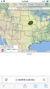
Latest day 2 from Bentley
30 TO 35 KNOTS OF
EFFECTIVE SHEAR DURING THE AFTERNOON. THIS WOULD SUPPORT A SUPERCELL
STORM MODE. IF THIS DISCRETE STORM MODE CAN BE MAINTAINED, A EF2+
TORNADO THREAT WILL EXIST GIVEN THE NEARLY PURELY STREAMWISE
VORTICITY IN THE LOWEST 2KM FROM RAP FORECAST SOUNDINGS IN THE
REGION. LIMITING FACTORS TO THIS SCENARIO ARE MULTIPLE STORMS
DEVELOPING ALONG THE FRONT AND QUICKLY GROWING UPSCALE AND A LACK OF
STRONG VENTING FLOW ALOFT WHICH MAY RESULT IN DISRUPTIVE DOWNBURSTS
BEFORE A MORE ORGANIZED, STRONG LOW-LEVEL MESOCYCLONE CAN DEVELOP.
30 TO 35 KNOTS OF
EFFECTIVE SHEAR DURING THE AFTERNOON. THIS WOULD SUPPORT A SUPERCELL
STORM MODE. IF THIS DISCRETE STORM MODE CAN BE MAINTAINED, A EF2+
TORNADO THREAT WILL EXIST GIVEN THE NEARLY PURELY STREAMWISE
VORTICITY IN THE LOWEST 2KM FROM RAP FORECAST SOUNDINGS IN THE
REGION. LIMITING FACTORS TO THIS SCENARIO ARE MULTIPLE STORMS
DEVELOPING ALONG THE FRONT AND QUICKLY GROWING UPSCALE AND A LACK OF
STRONG VENTING FLOW ALOFT WHICH MAY RESULT IN DISRUPTIVE DOWNBURSTS
BEFORE A MORE ORGANIZED, STRONG LOW-LEVEL MESOCYCLONE CAN DEVELOP.
Kds86z
Member
Gosh I love his discussions.Latest day 2 from Bentley
30 TO 35 KNOTS OF
EFFECTIVE SHEAR DURING THE AFTERNOON. THIS WOULD SUPPORT A SUPERCELL
STORM MODE. IF THIS DISCRETE STORM MODE CAN BE MAINTAINED, A EF2+
TORNADO THREAT WILL EXIST GIVEN THE NEARLY PURELY STREAMWISE
VORTICITY IN THE LOWEST 2KM FROM RAP FORECAST SOUNDINGS IN THE
REGION. LIMITING FACTORS TO THIS SCENARIO ARE MULTIPLE STORMS
DEVELOPING ALONG THE FRONT AND QUICKLY GROWING UPSCALE AND A LACK OF
STRONG VENTING FLOW ALOFT WHICH MAY RESULT IN DISRUPTIVE DOWNBURSTS
BEFORE A MORE ORGANIZED, STRONG LOW-LEVEL MESOCYCLONE CAN DEVELOP.