

Navigation
Install the app
How to install the app on iOS
Follow along with the video below to see how to install our site as a web app on your home screen.
Note: This feature may not be available in some browsers.
More options
-
Welcome to TalkWeather! We see you lurking around TalkWeather! Take the extra step and join us today to view attachments, see less ads and maybe even join the discussion. CLICK TO JOIN TALKWEATHER
You are using an out of date browser. It may not display this or other websites correctly.
You should upgrade or use an alternative browser.
You should upgrade or use an alternative browser.
Severe Weather 2026
- Thread starter KevinH
- Start date

WeathermanLeprechaun
Member
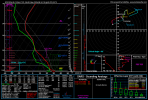
Southern France next week holds concern for a potentially anomalous European severe weather outbreak. Models seem to favor more of a linear progression but i have NEVER seen 70+ kt effective shear with these thermodynamics in place, never mind in Europe.

CheeselandSkies
Member
That sounding looks a bit convectively contaminated based on the omega bars on the left, but even so you don't see that too often in Europe.
WeathermanLeprechaun
Member
There's no real way to get one not contaminated. There is precip right over the parameter space hence the omega barsThat sounding looks a bit convectively contaminated based on the omega bars on the left, but even so you don't see that too often in Europe.
Weatherguyx
Member
CheeselandSkies
Member
There's no real way to get one not contaminated. There is precip right over the parameter space hence the omega bars
Yeah, I often run into that problem too, especially when trying to get one in close proximity to a simulated supercell on a CAM run.


Kds86z
Member
Oh nice I’m in that blue below circle.
Kds86z
Member
Could see few tornadoes today
WeathermanLeprechaun
Member
Low confidence call but some ML products have hinted at a tornado threat tomorrow in NW IA/S MN. Seems to me like low level stability would make for a overnight structure-show but until the 12z suite tomorrow, we won't call this one out. Models sniffing some sneaker destabilising at play?
.
.

KakashiHatake2000
Member
New spc update https://www.spc.noaa.gov/products/outlook/day1otlk.html
Kds86z
Member
Multiple tornado warnings
akt1985
Member
Late night Severe Thunderstorm Watch for southeast MissouriMultiple tornado warnings
WeathermanLeprechaun
Member
A mix of supercells, prefrontal convection and line segments should drive a tornado threat in the Mid-Atlantic today. Likely to be weak spinups so WATCH OUT for egregious tornado warnings..... /s. this should start as early as 19z-21z and continue into 02z-03z as everything goes linear before going offshore. Think QLCS production could definitely be up there today.
We may also have enough for supercell development later on in Central MN. I would say more structureshow than anything but nonzero tornado threat exists.
hear me out!
There may be enough to support a isolated spinup tomorrow with large hail in N IL. This areas in a general tstm risk for tomorrow but I think a Marginal Risk could eventually be needed for the area.
We may also have enough for supercell development later on in Central MN. I would say more structureshow than anything but nonzero tornado threat exists.
hear me out!
There may be enough to support a isolated spinup tomorrow with large hail in N IL. This areas in a general tstm risk for tomorrow but I think a Marginal Risk could eventually be needed for the area.
I just shared this message with a bunch of people that I know, telling them to watch out for bogus forecasts like that.

jackhutwx
Member
yeah I did see that stormnet is picking up something tomorrow for N/NE IL, rrfs is also picking up some activity there. watching it carefullyA mix of supercells, prefrontal convection and line segments should drive a tornado threat in the Mid-Atlantic today. Likely to be weak spinups so WATCH OUT for egregious tornado warnings..... /s. this should start as early as 19z-21z and continue into 02z-03z as everything goes linear before going offshore. Think QLCS production could definitely be up there today.
We may also have enough for supercell development later on in Central MN. I would say more structureshow than anything but nonzero tornado threat exists.
hear me out!
There may be enough to support a isolated spinup tomorrow with large hail in N IL. This areas in a general tstm risk for tomorrow but I think a Marginal Risk could eventually be needed for the area.
WeathermanLeprechaun
Member
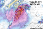
This is a extremely helpful survey. If you want to distinguish AI gen photos from real tornadoes and give your thoughts on the current state of people using AI on graphics and videos, here you go.
I personally think it's unfortunate how many have forgot basic graphic skills. I'm inexperienced but remember when I managed to overlap the LLJ with composite reflectivity on 6/11 and made a basic graphic? Didn't use AI for this.
Attachments
WeathermanLeprechaun
Member
Yep. I did notice the RRFS getting convection up there.yeah I did see that stormnet is picking up something tomorrow for N/NE IL, rrfs is also picking up some activity there. watching it carefully
Ironically, the RRFS is a superb model for firing convection in areas where other models may not, it's just you need to heed caution of its storm mode depiction. It seems to like the idea of something firing up for a hour or two, maybe posing that isolated all svr hazards threat and just dying out.
CheeselandSkies
Member
Interesting signal for discrete convection on both RRFS and 3K NAM for tomorrow. Would like to see the bulk shear be a little stronger, but worth keeping an eye on.