
- Thread starter
- #281

An override by the JTWC set it at 175 mph (150 kts)Unless post analysis says otherwise, Dolphin peaked at 165mph
Follow along with the video below to see how to install our site as a web app on your home screen.
Note: This feature may not be available in some browsers.
An override by the JTWC set it at 175 mph (150 kts)Unless post analysis says otherwise, Dolphin peaked at 165mph
Not technically right on being the first time since 2002. 2015 had Maysak, Noul, Dolphin and Soudelor (Soudelor formed at the end of July, though it became a 155 kt/180 mph Category 5 typhoon in the early days of August, but technically it counts because it formed in the last days of July)With Super Typhoon Dolphin becoming a category 5, it's the first time since 2002 that the Western Pacific has had 3 category 5 typhoons before August. Which ended up being the total number of category 5 typhoons that entire season. Gonna be interesting to see how many category 5 typhoons we have this season.

O okay. I missed 2015 somehow. I'm sorryNot technically right on being the first time since 2002. 2015 had Maysak, Noul, Dolphin and Soudelor (Soudelor formed at the end of July, though it became a 155 kt/180 mph Category 5 typhoon in the early days of August, but technically it counts because it formed in the last days of July)
It’s all good, but your point does still stand of three Category 5 storms before AugustO okay. I missed 2015 somehow. I'm sorry
Which means we will be stuck with operational analysis 2025 onwardsBad news @JPWX and tropical crew:
JTWC will no longer publicize their best track analysis for all seasons 2025 and onwards, this appears to apply to all basins that the JTWC tracks. I do not know if this is really true, but if it is, 2024 and back will keep their best track analysis.

Honestly pretty ridiculous and not sure why they made that decision.Which means we will be stuck with operational analysis 2025 onwards
I’m still trying to find a citation for it, because I found out from Nathan on YT, who is a reliable YTer.Honestly pretty ridiculous and not sure why they made that decision.
The system has consolidated since last night, and it is now Tropical Depression Nangka by JTWC, and the JTWC expects Nangka to become a short-lived Tropical Storm in the next day or so before encountering increasingly hostile conditions.The monsoon gyre in the WPAC spits out one last system in newly Tropical Storm Nangka, however the JTWC still maintains it as Invest 91W with a medium chance of development in the next 24-48 hours.
Like with several other systems that ultimately would end up becoming tropical cyclones later on their life in this year’s season, except Haishen, which Haishen never became a TC according to the JTWC, JMA named Nangka/91W far too early.
Regardless, Nangka is the 17th named storm of the season in the Western Pacific, continuing the monicker of this season being the most active to this point since 1971.
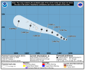
Here is that forecast from the NHC/CPHC on Potential Tropical Cyclone One-C:Also for the first time just 21 minutes ago, we got a Potential Tropical Cyclone in the Central Pacific basin, the first CPAC PTC since PTC advisories began in 2017.
Potential Tropical Cyclone One-C is as of the first forecast just released recently, expected to be near hurricane strength as it approaches the big island of Hawaii, and the forecast holds it near hurricane strength after passing directly over the big island and continuing westward remaining near hurricane strength.
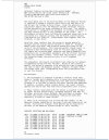

HAFS-B seems pretty aggressive with the strength compared to other models. Lots of model agreement on this one, though, as far as direction.Also for the first time just 21 minutes ago, we got a Potential Tropical Cyclone in the Central Pacific basin, the first CPAC PTC since PTC advisories began in 2017.
Potential Tropical Cyclone One-C is as of the first forecast just released recently, expected to be near hurricane strength as it approaches the big island of Hawaii, and the forecast holds it near hurricane strength after passing directly over the big island and continuing westward remaining near hurricane strength.
I’m seeing the GFS have PTC One-C crossing the IDL and into the WPAC on recent model runs.HAFS-B seems pretty aggressive with the strength compared to other models. Lots of model agreement on this one, though, as far as direction.
It's been 5 years since a tropical storm has made landfall on Hawaii, and the last hurricane to make landfall was 1992.
Yes on Iniki.I’m seeing the GFS have PTC One-C crossing the IDL and into the WPAC on recent model runs.
As regards to 1992, the infamous Hurricane Iniki is the storm I’m guessing you are referring to?
1992 was an interesting year, you had a Major Hurricane in the middle of winter in the CPAC in Hurricane Ekeka, then two months later similar circumstances that led to Ekeka forming led to Tropical Storm Hali forming.Yes on Iniki.
Despite not officially being an El Niño year, the atmosphere sure behaved like one that year.1992 was an interesting year, you had a Major Hurricane in the middle of winter in the CPAC in Hurricane Ekeka, then two months later similar circumstances that led to Ekeka forming led to Tropical Storm Hali forming.
Then you had in the ATL Hurricane Andrew, which was a very devastating Category 5 hurricane in Florida.
Yeah, and the ATL wasn’t very active that year with 6 named storms and a pre-season subtropical storm.Despite not officially being an El Niño year, the atmosphere sure behaved like one that year.