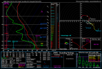
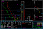
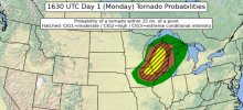
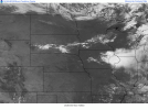
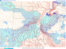
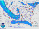
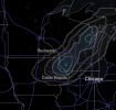
ASTORP is pretty bullish for 21z-00z tonight. Stormnet is also showing a 20% chance in the same area for the same timeframe
Follow along with the video below to see how to install our site as a web app on your home screen.
Note: This feature may not be available in some browsers.


Low level stability will be non existent today.I have questions about low level stability and etc, but an intense tornado isn't completely ruled out today. Strong vertical instability aloft may compensate for this. Extremely interesting day coming up.
Understandable but this sounding seems to reveal some remnant stability of sorts, from SW WI in the vicinity of one of your supercells. SE storm mode is finicky, but i think it can work out. I'm paying lots of attention to how cells orient themselves in the warm sector with these type of decent ceiling events, and i think this is one of those events where it'll manage given your comments regarding the orthogonal jet streak over PBL winds and etc which is found to have produced some of your more potent events. I'm still questioning low level thermodynamics, but shear in this sounding can absolutely compensate for those lower levels.Low level stability will be non existent today.
Honestly the only failure mode I see are storm motion vectors. Supercells need to deviate hard right wind when your PBL winds are southwest to northeast orientated to fully take in streamwise vorticity.
If they stay on an east south east trajectory instead of straight southeast, especially since storm motions will be up to 30-40+knots, and the LLJ speed will be 30-40+knots too (coming from west to east), then expect to see an outflow dominated congo line. The relatively dry mid levels also exacerbates this issue as well.
That vertical profile is actually exactly what you want in terms of thermos.Understandable but this sounding seems to reveal some remnant stability of sorts, from SW WI in the vicinity of one of your supercells. SE storm mode is finicky, but i think it can work out. I'm paying lots of attention to how cells orient themselves in the warm sector with these type of decent ceiling events, and i think this is one of those events where it'll manage given your comments regarding the orthogonal jet streak over PBL winds and etc which is found to have produced some of your more potent events. I'm still questioning low level thermodynamics, but shear in this sounding can absolutely compensate for those lower levels.
Yeah that's a good point. You don't want overmixing but I would rather prefer a more steady low level profile if that makes sense. Moisture quality and spreads are fine but how we distribute those low levels is a bit finicky. We'll see. Double edged sword is a good way to put it. It could help or it could ruin. I am aware that I picked a slightly contaminated sounding but it's better than cherrypicking STP like most do. Let me see if I can find a sounding that has a different vertical profile of sorts.The vertical profile is actually exactly what you want in terms of thermos.
Thanks to the left over MCS cold pool, over mixing would’ve been a likely death sentence to any sort of tornadogenesis potential. The LLLR take a hit but is astronomically a better solution (for tornado potential) than what could’ve been a 20+ degree dew point spread.
But even with that, as you see with that vertical profile, from the surface to the mid levels, the air is quite dry, and it’s being strongly advected from the west, that could keep updrafts anemic, especially with how diffuse the cold front is. At the same time, it’s those reasons as to why the storm mode will be discrete, so a double edged sword there.
I suspect that the strong forcing mechanism will easily sustain strong updrafts, as every cam models suggests this.

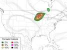
SPC upgraded to 10 hatch via IEMbot
Storm Prediction Center Jul 20, 2026 1630 UTC Day 1 Convective Outlook
Severe weather, tornado, thunderstorm, fire weather, storm report, tornado watch, severe thunderstorm watch, mesoscale discussion, convective outlook products from the Storm Prediction Center.www.spc.noaa.gov

I have stronger confidence in a intense tornado ie two due to this video by meteorologist Chris Jakob which finds that when 200mb flow is orthogonal to your main initiating boundary between 210-270 degrees like today has, outbreaks tend to perform better. Wanna watch this video? IMHO, this is more groundbreaking than the OMEGA project. This is something to consider in the future with events. This is a extremely brilliant discussion.
Touches on 5/20/19 and 3/15/25 as underperforming cases
I didn't mean to call 3/15 a underperformance, first correction there on my comment. Moreso i think that in cases where your flow is not orthogonal and parallel, you rely on confluence bands instead of your main initiating boundary. Case in hand, 3/15/25. Didn't verify on the main initiating boundaries and needed confluence bands to get your tornado threat going. I trying to find a email for Chris because I want to contact him regarding the 5/6/24 200mb. It doesn't feature a 100+ kt 200mb jet and has 70+ kt flow, albeit orthogonal but it is also parallel as it centers off into C OK/S KS. I wonder if flow being orthogonal initially helped the discrete mode but as this parallel feature of sorts became prominent towards 00z, storms clustered significantly. Or simply, weaker 200mb flow couldn't verify a significant event. I might contact our other Chris about this too.That's interesting. I tend to overlook 200mb flow when forecasting; focusing on 500mb and below as important to tornadoes. I suspect I'm not alone in that. I will have to reconsider that approach.