Kds86z
Member
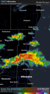
Yep. Multiple homes damaged1 in Wisconsin too.
Follow along with the video below to see how to install our site as a web app on your home screen.
Note: This feature may not be available in some browsers.
Yep. Multiple homes damaged1 in Wisconsin too.
Obviously hindsight is 20/20. But there really was no reason to assume that the massively delayed timing wouldn’t end up as a bust.Hate to keep going on about this but this was another partial reason why I kept digging at it in the thread. It felt a bit unfair because this setup legitimately looked like it had all arms up ready to get on its knees and end it there. There was no possible way I thought at that moment we could verify this event. Mother Nature works her way into stuff though. Once again, a lot of my comments came from pent up frustrations over general forecasting decisions and also of course a risky call backfiring off here. Things did work after dark after all.
Trey’s video breakdown of the setup might be worth revisiting after tonight. I believe he mentioned the full tornado threat may not materialize until 6-7 PMSo far, based on radar presentation.
1 sig tor in Iowa.
2 sig tor in Illinois
1 sig, tor and 1 vi torn in IN
So that’s 4 sig tors and 1 vi tor.
So still on the lower end of verification and no long trackers, but far from a bust.
The surface inversion that done in tornadogenesis earlier in the evening had largely went away due to sufficient mixing from persistent warm air advection from the intensifying LLJ. This allowed supercells to finally become surface based and tap into that high streamwise vorticity.
Obviously though, it didn’t go away completely, as the air is still pretty dry at the LFC, which most certainly is causing these cells to become outflow dominant, which again thwarted long trackers.
Overall though, this event verified, barely.
Definitely was unwise to call the event off, although to my and others defense, there was no reason to suggest otherwise as both the dryline completely failed to produce tornadoes and the boundary riders didn’t start to produce until after dark, which absolutely none of the cams (specifically today) were forecasting that scenario.
View attachment 53648
I don’t watch him, but even that timeline ended up being almost 2 hours too early.Trey’s video breakdown of the setup might be worth revisiting after tonight. I believe he mentioned the full tornado threat may not materialize until 6-7 PM
in his video earlier today based on what some of the models were suggesting.

yeah the rotation looks strong but the actual couplet is still pretty broadThat Indiana cell has been on the verge for a while now. Surprised it hasn't done it yet.
Inflow is beginning to increase, it may do it soon.yeah the rotation looks strong but the actual couplet is still pretty broad
A little tighter on the latest scan. It's trying.yeah the rotation looks strong but the actual couplet is still pretty broad