Kds86z
Member
Thanks.Was found via research by locomusic01 and it’s in his Stormstalker blog entry on this tornado. No photo of it exist though.
Here @iujkiaweatherman
Follow along with the video below to see how to install our site as a web app on your home screen.
Note: This feature may not be available in some browsers.
Thanks.Was found via research by locomusic01 and it’s in his Stormstalker blog entry on this tornado. No photo of it exist though.

Another one in Greene County c. 1965 - sheet 1, panel HF-3GG-251
View attachment 52759
Also very weak.

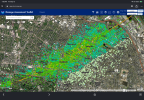
 Overlaying the path on Google Earth and deducing width through that, you get a maximum radius of 1.63±0.10 miles in diameter (the "±0.10" accounts for potential errors in tilt with the imagery, so the range is 1.53 to 1.73 miles in width) making it the ~19th-widest ever officially recorded and the second-largest ever recorded in the Southern United States after the Bassfield-Soso, MS, EF4 in 2020. The maximum width per the NWS was only 100 yards but that's obviously wrong. The area I have highlighted in red may be a secondary circulation or cell that "merged" with the mesocyclone, causing it to constrict; this is probably why the path after is so thin.


What in the world???So, nws St. Louis decided they were gonna produce the most excessively detailed tornado survey of all time. What in the world is this? I would post it in this in the may 16th 2025 thread but idk how to access it again since taking it off my watched list.
This is the most absurd survey I’ve seen.

That is actually absurd but I’m all for it.
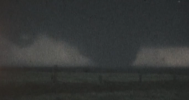
First true aerial photo of the Flint Beecher tornado, really highlights just how narrow it was, which makes the incredibly localized high death toll even more shocking.

Diaz also had a very short lead time:Was farting around with IEMBot and got curious in tornadic lead times via warnings; turns out the Westmoreland EF3 in 2024 had a ~2 minute lead time before actually hitting town.
View attachment 53011


Nice work! Have you seen this Phil Campbell video that was posted a few weeks ago? The audio is incredible.View attachment 53049
Currently working on a project that involves geolocating every known photo or video taken of the 4/27/2011 Hackleburg-Phil Campbell EF5. For being so "undocumented", it's quite surprising how much of this tornado's path is actually recorded - most of its trek through North Huntsville and basically everywhere after the river is covered.
Nice work! Have you seen this Phil Campbell video that was posted a few weeks ago? The audio is incredible.
Nice work! Have you seen this Phil Campbell video that was posted a few weeks ago? The audio is incredible.


Very large tornado on the night of April 27; not sure which. If by some miracle anyone knows anything about where this was taken, when it was taken or who took it please please please hit me up as I have a sneaking suspicion this could be New Harmony due the funnel's resemblance with the other photo taken of it. Impossible to say without more info though. If so this is an extremely historic find in the 4/27 sphere.
View attachment 53062