• Welcome to TalkWeather!
    We see you lurking around TalkWeather! Take the extra step and join us today to view attachments, see less ads and maybe even join the discussion.
    CLICK TO JOIN TALKWEATHER

Severe Weather Threat May 16-18, 2026

I'm not sure what's going on here, but we have a 15% hatched tornado risk on the SPC page but only an enhanced risk?
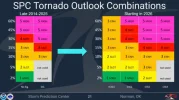
I had to do a brief refresher on this myself yesterday. Here’s how the new conditional intensity hatching affects what level of risk they put out.
 

Attachments

  • IMG_4565.webp
    IMG_4565.webp
    41.1 KB · Views: 24
This storm that’s approaching Dane County may need a tornado warning soon. I am guessing it may not be surface-based, but it’s showing increasingly intense rotation on both the La Crosse and Milwaukee radars.

It just went severe warned as I was writing this, and the storm back to the west of this is rotating now as well.
 

Attachments

  • IMG_4585.png
    IMG_4585.png
    1.9 MB · Views: 17
  • IMG_4586.png
    IMG_4586.png
    1.6 MB · Views: 8
  • IMG_4587.png
    IMG_4587.png
    1.8 MB · Views: 17
From new day 1

..SOUTH-CENTRAL KS INTO THE EASTERN TX PANHANDLE AND WESTERN OK


SOME GUIDANCE CONTINUES TO SHOW AT LEAST ISOLATED HIGH-BASED
CONVECTION DEVELOPING BY LATE AFTERNOON ACROSS PARTS OF
NORTH-CENTRAL KS SOUTHWARD INTO THE EASTERN TX PANHANDLE/WESTERN OK.
ANY THUNDERSTORMS WHICH CAN BE SUSTAINED WOULD LIKELY BE
SUPERCELLULAR AND CAPABLE OF ALL SEVERE HAZARDS, INCLUDING LARGE TO
VERY LARGE HAIL AND TORNADOES. INCREASING LOW-LEVEL SHEAR AFTER 00Z
SUPPORTS A CONDITIONAL RISK FOR A STRONG TORNADO.
 
Back
Top