
Ehhh, it certainly has potential, but there's a lot more model disagreement in the magnitude of the threat. The NAM can tend to be overcooked for some of these events.Maybe a unpopular opinion, but I now think Tuesday is the more volatile day, across the Tennessee valley and north Mississippi
Navigation
Install the app
How to install the app on iOS
Follow along with the video below to see how to install our site as a web app on your home screen.
Note: This feature may not be available in some browsers.
More options
-
Welcome to TalkWeather! We see you lurking around TalkWeather! Take the extra step and join us today to view attachments, see less ads and maybe even join the discussion. CLICK TO JOIN TALKWEATHER
You are using an out of date browser. It may not display this or other websites correctly.
You should upgrade or use an alternative browser.
You should upgrade or use an alternative browser.
Severe Weather Threat 4/27-4/28
- Thread starter Bulkshear
- Start date
slenker
Member
IIRC the kinematics for 5/21/24 were actually not that impressive, not what you’d expect out of a setup that produced a borderline EF5 strength tornado. As a result, a couple of the tornadoes that day were landspouts that ended up transitioning into full-fledged mesocyclonic tornadoes, which includes Greenfield. There were some really cool storm interactions and small scale features going on during that event.
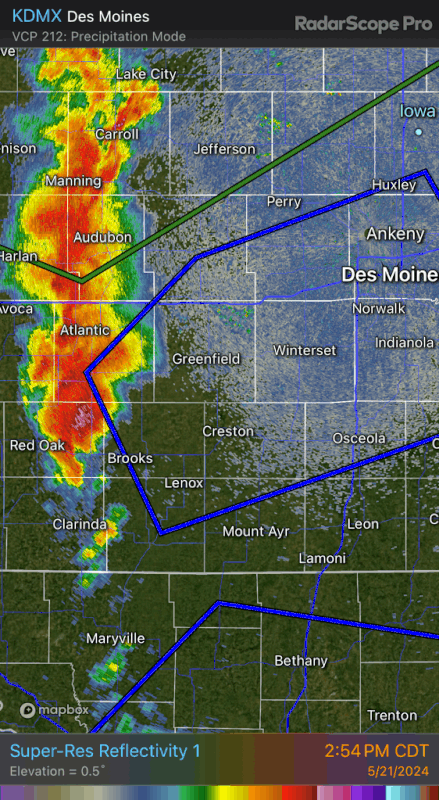
Here's what the May 21st, 2024 outbreak looked like at 3pm when a large MCS had just moved out of the area at 10am. I have no idea if the kinematics are even remotely similar, but the simulated reflectivity on the HRRR is definitely giving me Deja Vu.
The fact that such a setup was still able to produce a tornado with some of the fastest winds ever recorded should say something about how things can behave on the small scale regardless of the large-scale picture (after all, mesocale accidents are a thing, and we can even get down to storm-scale accidents or smaller as well!).IIRC the kinematics for 5/21/24 were actually not that impressive, not what you’d expect out of a setup that produced a borderline EF5 strength tornado. As a result, a couple of the tornadoes that day were landspouts that ended up transitioning into full-fledged mesocyclonic tornadoes, which includes Greenfield. There were some really cool storm interactions and small scale features going on during that event.
IIRC the kinematics for 5/21/24 were actually not that impressive, not what you’d expect out of a setup that produced a borderline EF5 strength tornado. As a result, a couple of the tornadoes that day were landspouts that ended up transitioning into full-fledged mesocyclonic tornadoes, which includes Greenfield. There were some really cool storm interactions and small scale features going on during that event.
I remember it was a moderate day with a 15% hatched, so it had something going for it.
Weatherguyx
Member
I'm noticing more uses of the new Cig # feature of late. Is this something to kind of replace forecasting less moderates and or high-risk days?
IIRC, 05/27/1997 (the outbreak that produced the notorious Jarrell, Texas, tornado) was also a Moderate Risk despite the unusual setup and the questions surrounding how things might play out.I remember it was a moderate day with a 15% hatched, so it had something going for it.
WeathermanLeprechaun
Member
There was like 300-400 0-1km SRH this day. The CAPE and small scale features really helped a otherwise unusually clustered event.IIRC the kinematics for 5/21/24 were actually not that impressive, not what you’d expect out of a setup that produced a borderline EF5 strength tornado. As a result, a couple of the tornadoes that day were landspouts that ended up transitioning into full-fledged mesocyclonic tornadoes, which includes Greenfield. There were some really cool storm interactions and small scale features going on during that event.
warneagle
Member
It’s there to allow them to indicate an event that’s high ceiling but low floor. Exactly like the last few days where storms may not fire but if they do it could get ugly.I'm noticing more uses of the new Cig # feature of late. Is this something to kind of replace forecasting less moderates and or high-risk days?
Mrgolfman7070
Member
I know im crazy for saying this but im ready for a big event in the mid south lol. Its been a long time since we got one.
tennessee storm chaser
Member
- Messages
- 1,880
- Reaction score
- 4,293
- Location
- jackson tennessee
- Special Affiliations
- SKYWARN® Volunteer
Hell been while since we had any rain man lolI know im crazy for saying this but im ready for a big event in the mid south lol. Its been a long time since we got one.
genie
Member
We were hammered by the storms last night in the Atlanta area. It was the first measurable rain we've had in like a month and the ponding on the roads from all of the runoff was scary to have to drive in. Terrific lightning show though!
Aaron Rider
Member
You can keep all that. I'll watch from a distance.I know im crazy for saying this but im ready for a big event in the mid south lol. Its been a long time since we got one.
Signed,
Central Pennsylvania and the East
Kds86z
Member
New day 2, tornado probs expanded?
bckhd2
Member
Crazy I’m in the ATL metro (ITP) and we hardly got any storms last night! Some lightning and a few rumbles of thunder but hardly any rain. I think 0.12” total on the dayWe were hammered by the storms last night in the Atlanta area. It was the first measurable rain we've had in like a month and the ponding on the roads from all of the runoff was scary to have to drive in. Terrific lightning show though!
Kds86z
Member
Kds86z
Member
Newest day 3
THERE REMAINS NOTABLE SPREAD WITHIN THE LATEST MODEL OUTPUT
CONCERNING THE FRONTAL PROGRESSION AND WHERE THE STRONGER FORCING
FOR ASCENT DEVELOPS WITH THE EVOLVING WAVE. A CONGLOMERATE
CONVECTIVE OUTFLOW BOUNDARY MAY ALSO INITIALLY PRECEDE THE FRONT
ACROSS THE NORTHERN GULF COAST STATES THROUGH ARK-LA-TEX AT THE
OUTSET OF THE PERIOD. EVEN SO, GUIDANCE SUGGESTS THAT A CORRIDOR OF
MODERATE TO STRONG POTENTIAL INSTABILITY WILL AGAIN DEVELOP ALONG
THE FRONTAL ZONE ACROSS PARTS OF THE SOUTHERN GREAT PLAINS INTO MID
SOUTH, AND PERHAPS NORTHEASTWARD THROUGH PORTIONS OF THE OHIO
VALLEY. AIDED BY FAVORABLE VERTICAL SHEAR NEAR THE SOUTHERN FRINGE
OF THE WESTERLIES, THIS ENVIRONMENT COULD BECOME CONDUCIVE TO THE
DEVELOPMENT OF SUPERCELL STRUCTURES AND ORGANIZING CLUSTERS WITH
POTENTIAL TO PRODUCE DAMAGING WIND GUSTS, LARGE HAIL AND PERHAPS A
RISK FOR TORNADOES.
genie
Member
Don't want to get too far off-topic, but I am up in Kennesaw close to Barrett Parkway/KSU.Crazy I’m in the ATL metro (ITP) and we hardly got any storms last night! Some lightning and a few rumbles of thunder but hardly any rain. I think 0.12” total on the day
tennessee storm chaser
Member
- Messages
- 1,880
- Reaction score
- 4,293
- Location
- jackson tennessee
- Special Affiliations
- SKYWARN® Volunteer
Dang alreadyNewest day 3
THERE REMAINS NOTABLE SPREAD WITHIN THE LATEST MODEL OUTPUT
CONCERNING THE FRONTAL PROGRESSION AND WHERE THE STRONGER FORCING
FOR ASCENT DEVELOPS WITH THE EVOLVING WAVE. A CONGLOMERATE
CONVECTIVE OUTFLOW BOUNDARY MAY ALSO INITIALLY PRECEDE THE FRONT
ACROSS THE NORTHERN GULF COAST STATES THROUGH ARK-LA-TEX AT THE
OUTSET OF THE PERIOD. EVEN SO, GUIDANCE SUGGESTS THAT A CORRIDOR OF
MODERATE TO STRONG POTENTIAL INSTABILITY WILL AGAIN DEVELOP ALONG
THE FRONTAL ZONE ACROSS PARTS OF THE SOUTHERN GREAT PLAINS INTO MID
SOUTH, AND PERHAPS NORTHEASTWARD THROUGH PORTIONS OF THE OHIO
VALLEY. AIDED BY FAVORABLE VERTICAL SHEAR NEAR THE SOUTHERN FRINGE
OF THE WESTERLIES, THIS ENVIRONMENT COULD BECOME CONDUCIVE TO THE
DEVELOPMENT OF SUPERCELL STRUCTURES AND ORGANIZING CLUSTERS WITH
POTENTIAL TO PRODUCE DAMAGING WIND GUSTS, LARGE HAIL AND PERHAPS A
RISK FOR TORNADOES.
Out ? Thought was 230. CST
That's the current Day 3 wording. Newest Day 3 won't come out until 2:30pm