• Welcome to TalkWeather!
    We see you lurking around TalkWeather! Take the extra step and join us today to view attachments, see less ads and maybe even join the discussion.
    CLICK TO JOIN TALKWEATHER

Severe Weather 2026

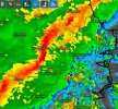
I observed a feature whilst looking through my squall line again from yesterday. A classic momentum surge here just entering the north side of the city. Very curious if a potentially tornadic circulation was developing here or just classic significant damaging wind gusts. Packed a punch, that's for sure.
 

Attachments

  • Screenshot_2026-03-13-23-16-37-816.jpeg
    Screenshot_2026-03-13-23-16-37-816.jpeg
    117.7 KB · Views: 0
Both hemispheres severe weather for tomorrow 3/16

Everyone already knows what’s in store for North America tomorrow...
1000012496.jpg
But in the Southern Hemisphere, more specifically in South America, an intense mid-to-upper-level cyclonic trough with a negative slope will cross the Andes and produce a considerable advection of negative vorticity (which would actually be positive for the Southern Hemisphere), resulting in a broad zone of synoptic lifting ahead of its associated semi-stationary cold front.
1000012534.png1000012540.png
In turn, this trough will trigger a strong activation of the SALLJ (South American Low-Level Jet) along the Andes, bringing significant low-level wind shear with winds of up to around 37 kt at 850 hPa, along with a large tongue of moisture from the Amazon basin with dew points hovering around 70°F.
1000012532.png1000012541.png
ML and MU-CAPE levels will also be very high, will bring more instability and severe weather later tomorrow afternoon.
1000012539.jpg
Currently, there is already severe activation in central Argentina:
1000012531.gif
 
Severe weather and tornado threats will be nonexistent for at least the next week or so. Thankful because it gives me time to breathe and work on more pressing things.
 
Severe weather and tornado threats will be nonexistent for at least the next week or so. Thankful because it gives me time to breathe and work on more pressing things.
We've got record breaking heat in the West and frigid cold in the East. When the pattern flips it'll set the table for something gnarly i'm sure.

It's hard to believe it's only mid-March. This severe weather season sure did kick off with a bang.
 
We've got record breaking heat in the West and frigid cold in the East. When the pattern flips it'll set the table for something gnarly i'm sure.

It's hard to believe it's only mid-March. This severe weather season sure did kick off with a bang.
Everything I am hearing. April going be wild ride on the severe train . Buckle up
 
Last edited:
Everything I am hearing. April going be wild ride on the severe train . Buckle up

Still a long ways out but I'm not hating what I'm seeing on the daily CFS runs for the timeframe of my chase tour...
 
Just some spreadsheet stats. I'll share Central MS data tomorrow.
North MS Tornado Spreadsheet (Updated to include EF1 Alcorn County Tornado):

Total TOR Count from 1800 to 2026 (North MS): 687

Total AM TOR Count from 1800 to 2026 (North MS): 182 (26%)

Total PM TOR Count from 1800 to 2026 (North MS): 503 (73%)

HIGHEST TORNADO COUNT BY COUNTY: 58 (MONROE)

LOWEST TORNADO COUNT BY COUNTY: 16 (BENTON)

LOWEST TORNADO AVERAGE BY COUNTY: 2.3% (BENTON)

HIGHEST TORNADO AVERAGE BY COUNTY: 8.4% (MONROE)

2ND HIGHEST TORNADO AVERAGE BY COUNTY: 8.2% (LEE)

3RD HIGHEST TORNADO AVERAGE BY COUNTY: 6.0% (DESOTO)

North MS has had 2,204 Tornado Warnings issued

COUNTIES WITH HIGHEST TOR WARNING COUNT

Marshall County 154 (7%)

Lafayette County 143 (6.5%)

Itawamba County 125 (5.7%)

Tishomingo County 119 (5.4%)

Prentiss County 118 (5.4%)

Panola County 117 (5.3%)

Tippah County 117 (5.3%)

Lee County 114 (5.2%)

Union County 114 (5.2%)

DeSoto County 108 (4.9%)

Benton County 106 (4.8%)

Monroe County 100 (4.5%)

Tate County 100 (4.5%)

Alcorn County 95 (4.3%)

COUNTIES WITH LOWEST TOR WARNING COUNT

Pontotoc County 93 (4.2%)

Quitman County 80 (3.6%)

Tunica County 76 (3.5%)

Chickasaw County 72 (3.3%)

Calhoun County 71 (3.2%)

Coahoma County 70 (3.2%)

Tallahatchie County 58 (2.6%)

Yalobusha County 54 (2.5%)

North MS has had 11,433 SEV Thunderstorm Warnings issued

COUNTIES WITH HIGHEST SEV WARNING COUNT

Lee County 736 (6%)

Itawamba County 672 (6%)

Marshall County 656 (6%)

Monroe County 635 (6%)

DeSoto County 629 (6%)

Pontotoc County 596 (5%)

Lafayette County 579 (5%)

Chickasaw County 552 (5%)

Union County 545 (5%)

Panola County 539 (5%)

COUNTIES WITH LOWEST SEV WARNING COUNT

Prentiss County 511 (4%)

Tippah County 507 (4%)

Benton County 498 (4%)

Tunica County 487 (4%)

Tate County 476 (4%)

Tishomingo County 468 (4%)

Alcorn County 420 (4%)

Calhoun County 415 (4%)

Coahoma County 398 (4%)

Quitman County 398 (3%)

Tallahatchie County 361 (3%)

Yalobusha County 355 (3%)
 
Back
Top