
15z RAP the non convective allowing close range models has a pretty volatile atmosphere now in Alabama. All signs point to a increase in threat here than what the spc is currently showing. It's upticked some.
Navigation
Install the app
How to install the app on iOS
Follow along with the video below to see how to install our site as a web app on your home screen.
Note: This feature may not be available in some browsers.
More options
-
Welcome to TalkWeather! We see you lurking around TalkWeather! Take the extra step and join us today to view attachments, see less ads and maybe even join the discussion. CLICK TO JOIN TALKWEATHER
You are using an out of date browser. It may not display this or other websites correctly.
You should upgrade or use an alternative browser.
You should upgrade or use an alternative browser.
Severe Weather 3/15 - 3/16
- Thread starter CheeselandSkies
- Start date
KakashiHatake2000
Member
NorthGaWeather
Member
The Day 2 really captured my thoughts for the AL/GA portion of this event. The line should feature a more cellular/broken look by the late evening and overnight, IMO. Should be a pretty widespread wind event at least.
KakashiHatake2000
Member
Trey is circling three areas starting off with the parts of the Midwest and ohio valley region (brief tornado threat due to lack of instability including with squall line up there due to the wind profile) next with the mid south region and then also the gulf coast Deep South region (both better areas first with Midsouth potentially having better supercell potential but I’m still expecting short window with that but still could continue) (and second with warm air advection supercells possibly in the gulf coast and Deep South states)) and lastly also the Carolinas region (conditional but big if for if the shortwave fires off thunderstorms with all severe hazards)
Last edited:
Kds86z
Member
Day 3 taking a bit.
I honestly think central and south Alabama, well a large majority of Alabama has a shot at a moderate, it's not high chance but I think depending on how the future hrrr runs and models go we could see a moderate.
SmokeEater
Member
Day 3 is 10 minutes late at this point....
Kds86z
Member
It’s out and .. it’s a doozy
Kds86z
Member
Possible mdt risk later..
Ozonelayer
Member
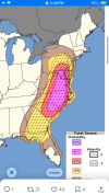
"PRIMARY CHANGES THIS OUTLOOK ARE TO ADD A 45 TOTAL SEVERE
PROBABILITY ALONG WITH MINOR NORTHEAST AND SOUTHEAST EXPANSION TO
THE CATEGORICAL RISK AREAS. PORTIONS OF THE REGION, CENTERED ON SC
TO MD, MAY WARRANT AN UPGRADE TO A LEVEL 4/MODERATE RISK IN LATER
OUTLOOKS."
Hot damn
PROBABILITY ALONG WITH MINOR NORTHEAST AND SOUTHEAST EXPANSION TO
THE CATEGORICAL RISK AREAS. PORTIONS OF THE REGION, CENTERED ON SC
TO MD, MAY WARRANT AN UPGRADE TO A LEVEL 4/MODERATE RISK IN LATER
OUTLOOKS."
Hot damn
KevinH
Member
What parameters ARE YOU LOOKING AT??!?! lol15z RAP the non convective allowing close range models has a pretty volatile atmosphere now in Alabama. All signs point to a increase in threat here than what the spc is currently showing. It's upticked some.
Kds86z
Member
"PRIMARY CHANGES THIS OUTLOOK ARE TO ADD A 45 TOTAL SEVERE
PROBABILITY ALONG WITH MINOR NORTHEAST AND SOUTHEAST EXPANSION TO
THE CATEGORICAL RISK AREAS. PORTIONS OF THE REGION, CENTERED ON SC
TO MD, MAY WARRANT AN UPGRADE TO A LEVEL 4/MODERATE RISK IN LATER
OUTLOOKS."
Hot damn
Attachments
Kds86z
Member
Not often you see strong tornadoes mentioned with Maryland …
UpperLevelLOL
Member
UpperLevelLOL
Member
Sorry for the twitter spam, but uhhhhh not loving this RRFS run showing a chonker discrete cell running along I-95 between Baltimore and Philly
Aaron Rider
Member
I don't think there's been an outbreak of multiple intense tornadoes in both Maryland and Virginia since 5/2/1929Not often you see strong tornadoes mentioned with Maryland …

18z hrrr doesn't have as much SRH as the nam as been having
tennessee storm chaser
Member
- Messages
- 1,877
- Reaction score
- 4,288
- Location
- jackson tennessee
- Special Affiliations
- SKYWARN® Volunteer
Sorry for the twitter spam, but uhhhhh not loving this RRFS run showing a chonker discrete cell running along I-95 between Baltimore and Philly
Dang it boy
genie
Member
Cancelled my plans to drive out to North Alabama to chase. With how things are looking in the Atlanta area, I might as well save the money, and wear and tear on my body, and observe what happens here at home. Trey pointed it out in his latest update, but there's increasing concern about the area from Atlanta to the Florida Panhandle for a localized elevated area of tornado potential, and I'll probably focus on that. Just hate that it'll be moving through in the early morning hours.