jiharris0220
Member
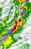
The forcing for tomorrow will be very strong since it’s a cold front rather than a dryline, so upscale growth is guaranteed despite the perpendicular orientation of the jet streak relative to the PBL winds, but there’s a potential caveat.
Because there will likely be a slight lack of available moisture and consequently plenty of surface mixing, I can see one of those scenarios where the storm mode starts out as QLCS and transitions to semi discrete.
Keep in mind the March 14th outbreak which happened last year exactly, had dews below 60 and so did the Tri state outbreak. Obviously not saying at all tomorrow will be anything near what those days were. At the very worst I can see one or three significant tornadoes occurring.