• Welcome to TalkWeather!
    We see you lurking around TalkWeather! Take the extra step and join us today to view attachments, see less ads and maybe even join the discussion.
    CLICK TO JOIN TALKWEATHER

Severe Weather 3/15 - 3/16

Sunday Through Monday:

The long term begins on Sunday, with increasing southwest flow
bringing moisture back into the region ahead of what is shaping up
to be an impressively dynamic weather system. Dewpoints surging into
the upper 50s to low 60s areawide and daytime temperatures in the
upper 60s to low 80s will support the chances for isolated to
scattered showers and thunderstorms on Sunday afternoon. Though all
eyes will be to our west as a deepening negatively tilted mid-level
trough approaches the Southeast bringing with it a strong cold
front. Given the strong dynamics at 500mbs and an increasing shear
environment
, another QLCS type event appears probable. This will
accompany a cold front that is currently progged to push through
North and Central Georgia between Sunday Night across far NW
Georgia through Monday afternoon across much of Central Georgia.
Exact timing and evolution of this system is still somewhat
unknown but confidence is growing that this system will bring
another round of severe weather (namely gusty/damaging winds and
tornadoes)
to the region early next week.

Taking a look at the global ensemble cluster analysis for
500mb reveals generally 3 different solutions...

1- A slower moving and highly amplified trough. This would result in
timing of showers and storms aligning more with daytime heating on
Monday thereby increasing the threat for severe weather occurring.

This accounts for roughly 45% of the ensembles.

2- A quicker moving and broader mid-level trough. This would result
in timing of showers and storms moving through earlier and allow
less time for destabilization. While severe weather potential is not
out of the question with this solution, the window of opportunity
for severe weather would be more limited. This accounts for 42% of
the ensembles.

3- A quicker moving and highly amplified mid-level trough. This
would result in a faster moving cold front but making for very windy
conditions (Wind Advisory conditions) as it exits. This accounts for
roughly 15% of the ensembles.

As previously mentioned our confidence is increasing that severe
weather will occur on Monday
and we are taking all of the solutions
mentioned above into account. As we continue to move into the
purview of the hi-res guidance we will be keeping a very close eye
on things
. Stay tuned...
Trying to quote this since it's long, hopefully it works. 3pm discussion from FFC is interesting. Mentions increasing confidence in severe weather and tornadoes, timing Sunday night through Monday afternoon. Starting to get worried this is all going to arrive in the Atlanta Metro during Monday morning rush hour. Expecting the SPC to move the risk areas into the AL/GA corridor in the next update.
 
Trying to quote this since it's long, hopefully it works. 3pm discussion from FFC is interesting. Mentions increasing confidence in severe weather and tornadoes, timing Sunday night through Monday afternoon. Starting to get worried this is all going to arrive in the Atlanta Metro during Monday morning rush hour. Expecting the SPC to move the risk areas into the AL/GA corridor in the next update.
Fairly strong wording for FFC - they're typically pretty squirrelly on discussing severe potential more than 36 hours out unless it's fairly high-confidence.
 
Trey mentions moisture issues up north, and this is true, but this definitely doesn't look to be an nearly as much of an issue down south, even truer if the system slows down any more than it has thus far.
 
Fairly strong wording for FFC - they're typically pretty squirrelly on discussing severe potential more than 36 hours out unless it's fairly high-confidence.
Yes, usually they’re twitchy about dropping the “severe” or “tornado” word, and they don’t usually go into that level of detail unless there’s a legitimate threat that bears watching. Hoping everyone in town stays weather aware this weekend
 
Trey mentions moisture issues up north, and this is true, but this definitely doesn't look to be an nearly as much of an issue down south, even truer if the system slows down any more than it has thus far.
Good point. Earlier Meg mentioned timing of Front has slowed down
 
From new Day 3:

...FL/AL Coast...
Toward the end of the period, richer low-level moisture will begin
to move inland across the FL Panhandle into southern Alabama. Within
this zone, discrete convection may develop after 08Z. If this were
to occur, strong shear would support supercells capable of
tornadoes.
 
Huge expansion of the ENH in new Day 3
45% hatch also added.
Day 3 Convective Outlook
NWS Storm Prediction Center Norman OK
0232 PM CDT Fri Mar 13 2026

Valid 151200Z - 161200Z

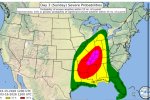
...THERE IS AN ENHANCED RISK OF SEVERE THUNDERSTORMS FROM THE LOWER
MISSISSIPPI RIVER VALLEY TO THE OHIO VALLEY....

...SUMMARY...
A widespread damaging wind event with some tornado threat is likely
on late Sunday afternoon through Sunday night from northeast Texas
to southwest Lower Michigan. The greatest wind threat appears to be
from northeast Arkansas/western Tennessee to southern Indiana during
the evening and overnight hours.

...Synopsis...
A 100+ knot mid-level jet will lead to rapid amplification as it
rounds the base of the mid-level trough across the Central Plains on
Sunday. As the associated surface cyclone moves northeastward
through the day, strong low-level moisture transport will occur
across the warm sector. This will result in weak to potentially
moderate instability ahead of the cold front Sunday afternoon. This
cold front will accelerate east-southeastward from the Midwest to
the Mid-Mississippi Valley during the afternoon and from Ohio to
western Georgia/eastern Alabama by Monday morning.

....Ohio Valley...
Despite dewpoints only increasing to the mid to upper 50s, a very
favorable kinematic environment will be in place with a 70 knot
low-level jet and nearly 125 knot mid-level jet by Monday morning.
Given this wind field, any instability, combined with the strong
frontal forcing, will be sufficient for a powerful QLCS during the
evening and overnight hours. This squall line will likely have
widespread 60+ mph wind gusts with some stronger 75+ mph wind gusts
possible.

In addition, very long hodographs with 200+ m2/s2 0-500m SRH will
support a threat for line-embedded tornadoes, some of which could be
strong. Additionally, the strong shear may also allow for some
embedded supercells, also depicted by the 12Z RRFS, which also may
lead to a locally greater tornado threat. Pre-frontal development
cannot be ruled out, especially from northeast Arkansas to southern
Illinois at the nose of the 500mb jet and the northern extent of the
richer low-level moisture. This scenario is more uncertain, but
could pose a greater tornado threat if it were to materialize.

...Lower Mississippi Valley to the Southeast...
The squall line will form during the afternoon, perhaps with some
initial supercell/hail threat across Arkansas and northeast Texas
and then move northeastward through the overnight period. The
strongest low-mid level wind field will remain north of this region,
however, greater instability will compensate and should maintain the
damaging squall line through the overnight hours. The greatest STP
values within the entire risk area are forecast (by the 12Z NAM)
between 03Z and 12Z from western Tennessee to central Mississippi
and northwest Alabama. Therefore, expect a QLCS tornado threat to
accompany the damaging wind threat through the overnight and early
morning period.

...FL/AL Coast...
Toward the end of the period, richer low-level moisture will begin
to move inland across the FL Panhandle into southern Alabama. Within
this zone, discrete convection may develop after 08Z. If this were
to occur, strong shear would support supercells capable of
tornadoes.

..Bentley.. 03/13/2026
1773430559978.png
 
Lower Mississippi Valley to the Southeast...
The squall line will form during the afternoon, perhaps with some
initial supercell/hail threat across Arkansas and northeast Texas
and then move northeastward through the overnight period. The
strongest low-mid level wind field will remain north of this region,
however, greater instability will compensate and should maintain the
damaging squall line through the overnight hours. The greatest STP
values within the entire risk area are forecast (by the 12Z NAM)
between 03Z and 12Z from western Tennessee to central Mississippi
and northwest Alabama. Therefore, expect a QLCS tornado threat to
accompany the damaging wind threat through the overnight and early
morning period.

...FL/AL Coast...
Toward the end of the period, richer low-level moisture will begin
to move inland across the FL Panhandle into southern Alabama. Within
this zone, discrete convection may develop after 08Z. If this were
to occur, strong shear would support supercells capable of
tornadoes.

We've discussed this, confluence band potential definitely peaks in Central al and around FL/AL border. It's still uncertain but basically spot on from Bentley.
 
New day 3…

..SUMMARY


A WIDESPREAD DAMAGING WIND EVENT WITH SOME TORNADO THREAT IS LIKELY
ON LATE SUNDAY AFTERNOON THROUGH SUNDAY NIGHT FROM NORTHEAST TEXAS
TO SOUTHWEST LOWER MICHIGAN. THE GREATEST WIND THREAT APPEARS TO BE
FROM NORTHEAST ARKANSAS/WESTERN TENNESSEE TO SOUTHERN INDIANA DURING
THE EVENING AND OVERNIGHT HOURS.

..SYNOPSIS


A 100+ KNOT MID-LEVEL JET WILL LEAD TO RAPID AMPLIFICATION AS IT
ROUNDS THE BASE OF THE MID-LEVEL TROUGH ACROSS THE CENTRAL PLAINS ON
SUNDAY. AS THE ASSOCIATED SURFACE CYCLONE MOVES NORTHEASTWARD
THROUGH THE DAY, STRONG LOW-LEVEL MOISTURE TRANSPORT WILL OCCUR
ACROSS THE WARM SECTOR. THIS WILL RESULT IN WEAK TO POTENTIALLY
MODERATE INSTABILITY AHEAD OF THE COLD FRONT SUNDAY AFTERNOON. THIS
COLD FRONT WILL ACCELERATE EAST-SOUTHEASTWARD FROM THE MIDWEST TO
THE MID-MISSISSIPPI VALLEY DURING THE AFTERNOON AND FROM OHIO TO
WESTERN GEORGIA/EASTERN ALABAMA BY MONDAY MORNING.

...OHIO VALLEY


DESPITE DEWPOINTS ONLY INCREASING TO THE MID TO UPPER 50S, A VERY
FAVORABLE KINEMATIC ENVIRONMENT WILL BE IN PLACE WITH A 70 KNOT
LOW-LEVEL JET AND NEARLY 125 KNOT MID-LEVEL JET BY MONDAY MORNING.
GIVEN THIS WIND FIELD, ANY INSTABILITY, COMBINED WITH THE STRONG
FRONTAL FORCING, WILL BE SUFFICIENT FOR A POWERFUL QLCS DURING THE
EVENING AND OVERNIGHT HOURS. THIS SQUALL LINE WILL LIKELY HAVE
WIDESPREAD 60+ MPH WIND GUSTS WITH SOME STRONGER 75+ MPH WIND GUSTS
POSSIBLE.

IN ADDITION, VERY LONG HODOGRAPHS WITH 200+ M2/S2 0-500M SRH WILL
SUPPORT A THREAT FOR LINE-EMBEDDED TORNADOES, SOME OF WHICH COULD BE
STRONG. ADDITIONALLY, THE STRONG SHEAR MAY ALSO ALLOW FOR SOME
EMBEDDED SUPERCELLS, ALSO DEPICTED BY THE 12Z RRFS, WHICH ALSO MAY
LEAD TO A LOCALLY GREATER TORNADO THREAT. PRE-FRONTAL DEVELOPMENT
CANNOT BE RULED OUT, ESPECIALLY FROM NORTHEAST ARKANSAS TO SOUTHERN
ILLINOIS AT THE NOSE OF THE 500MB JET AND THE NORTHERN EXTENT OF THE
RICHER LOW-LEVEL MOISTURE. THIS SCENARIO IS MORE UNCERTAIN, BUT
COULD POSE A GREATER TORNADO THREAT IF IT WERE TO MATERIALIZE.

..LOWER MISSISSIPPI VALLEY TO THE SOUTHEAST


THE SQUALL LINE WILL FORM DURING THE AFTERNOON, PERHAPS WITH SOME
INITIAL SUPERCELL/HAIL THREAT ACROSS ARKANSAS AND NORTHEAST TEXAS
AND THEN MOVE NORTHEASTWARD THROUGH THE OVERNIGHT PERIOD. THE
STRONGEST LOW-MID LEVEL WIND FIELD WILL REMAIN NORTH OF THIS REGION,
HOWEVER, GREATER INSTABILITY WILL COMPENSATE AND SHOULD MAINTAIN THE
DAMAGING SQUALL LINE THROUGH THE OVERNIGHT HOURS. THE GREATEST STP
VALUES WITHIN THE ENTIRE RISK AREA ARE FORECAST (BY THE 12Z NAM)
BETWEEN 03Z AND 12Z FROM WESTERN TENNESSEE TO CENTRAL MISSISSIPPI
AND NORTHWEST ALABAMA. THEREFORE, EXPECT A QLCS TORNADO THREAT TO
ACCOMPANY THE DAMAGING WIND THREAT THROUGH THE OVERNIGHT AND EARLY
MORNING PERIOD.

..FL/AL COAST


TOWARD THE END OF THE PERIOD, RICHER LOW-LEVEL MOISTURE WILL BEGIN
TO MOVE INLAND ACROSS THE FL PANHANDLE INTO SOUTHERN ALABAMA. WITHIN
THIS ZONE, DISCRETE CONVECTION MAY DEVELOP AFTER 08Z. IF THIS WERE
TO OCCUR, STRONG SHEAR WOULD SUPPORT SUPERCELLS CAPABLE OF
TORNADOES.

..BENTLEY.. 03/13/2026


Back
Top