
Some more damage pics from Aroma park I haven't seen in here.
Navigation
Install the app
How to install the app on iOS
Follow along with the video below to see how to install our site as a web app on your home screen.
Note: This feature may not be available in some browsers.
More options
-
Welcome to TalkWeather! We see you lurking around TalkWeather! Take the extra step and join us today to view attachments, see less ads and maybe even join the discussion. CLICK TO JOIN TALKWEATHER
You are using an out of date browser. It may not display this or other websites correctly.
You should upgrade or use an alternative browser.
You should upgrade or use an alternative browser.
Severe Weather 3/9 - 3/12
- Thread starter CheeselandSkies
- Start date
Aaron Rider
Member
Yeah it's around 60 via York airport. The sun is now out.I guess y’all are just outside of the current one in PA/WV/MD. It’s nice and warm here in DC and the sun is trying to peek out but the dews are still in the mid-50s down here. Seems like they’re hovering closer to 60 in the current watch area.
CSimonds
Member
Warm, right around 80 here with dews near 60. A Severe Thunderstorm Watch also just went out for parts of Middle TN and AL.
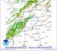
Storm Prediction Center Severe Thunderstorm Watch 46
Severe weather, tornado, thunderstorm, fire weather, storm report, tornado watch, severe thunderstorm watch, mesoscale discussion, convective outlook products from the Storm Prediction Center.
www.spc.noaa.gov
from NWS Baltimore/Washington:
...SEVERE WEATHER OUTBREAK EXPECTED OVER THE MID-ATLANTIC REGION
BETWEEN 2 PM AND 10 PM TODAY, INCLUDING THE GREATER
BALTIMORE/WASHINGTON METROPOLITAN AREAS...
An outbreak of severe storms is expected this afternoon and
evening across the greater Baltimore/Washington region, with
numerous severe thunderstorms expected. There is a significant
threat for damaging and locally destructive hurricane-force
winds, along with the potential for large hail and tornadoes, even
strong tornadoes.
The timing of this outbreak varies with your location. West of the
Blue Ridge Mountains, you can expect the storms to arrive between
12 Noon and 3 PM. East of the Blue Ridge Mountains, timing will
be from 4 PM to 8 PM. The greater Baltimore/Washington
Metropolitan Areas can expect the storms to arrive between 5 PM
and 7 PM.
Kolle
Member
NWS HUN in their 1:30 webinar mentioned a back-and-forth between them and SPC over what type of watch to issue. They decided to go with a SVR watch, but mentioned a tornado or two could be possible.
akt1985
Member
Fred Gossage pointed out on Tennessee Valley Weather that middle Tennessee is at greater risk for tree damage than when a QLCS moves through due to damage from the ice storm back in January.
Kds86z
Member
Close to me about an hour or so. very interestingfrom NWS Baltimore/Washington:
...SEVERE WEATHER OUTBREAK EXPECTED OVER THE MID-ATLANTIC REGION
BETWEEN 2 PM AND 10 PM TODAY, INCLUDING THE GREATER
BALTIMORE/WASHINGTON METROPOLITAN AREAS...
An outbreak of severe storms is expected this afternoon and
evening across the greater Baltimore/Washington region, with
numerous severe thunderstorms expected. There is a significant
threat for damaging and locally destructive hurricane-force
winds, along with the potential for large hail and tornadoes, even
strong tornadoes.
The timing of this outbreak varies with your location. West of the
Blue Ridge Mountains, you can expect the storms to arrive between
12 Noon and 3 PM. East of the Blue Ridge Mountains, timing will
be from 4 PM to 8 PM. The greater Baltimore/Washington
Metropolitan Areas can expect the storms to arrive between 5 PM
and 7 PM.
The southern half of this little line seems to be falling apart which is even more concerning.
Anti-Freeze
Member
After receiving a 2:30 am phone tornado warning, I went to a school listed as a storm shelter on the Russellville, AR city website, that was also in the warning box, but it never opened. The local sirens that test every Wed. went off about 2:45 and 2:55 while I was there, but doors never unlocked. Shelter doors are supposed to unlock during tor. warnings.
(I was keeping an eye on the radar, we were on the far north corner of the warning box and it was an isolated cell tracking well to the southeast, so was safe to sit in the parking lot and see if it would open.)
Glad the phone alert worked exactly as intended, was immediate and gave me a heads up about 30 miles away.
Holy $hit 376 hail reports yesterday. Easily going to be a multi-billion dollar storm

akt1985
Member
Starting to see a semi-supercell near Iuka, Mississippi.The southern half of this little line seems to be falling apart which is even more concerning.
Ryan Hall has Trey from Convective Chronicles on the livestream right now. Talk about a crossover!

It also appears that the RRFS model is handling this better than the HRRR. Current Radar vs. 12z RRFS at 2pm.

Glad you are safe but wow, that wouldn't have been good at all.After receiving a 2:30 am phone tornado warning, I went to a school listed as a storm shelter on the Russellville, AR city website, that was also in the warning box, but it never opened. The local sirens that test every Wed. went off about 2:45 and 2:55 while I was there, but doors never unlocked. Shelter doors are supposed to unlock during tor. warnings.
(I was keeping an eye on the radar, we were on the far north corner of the warning box and it was an isolated cell tracking well to the southeast, so was safe to sit in the parking lot and see if it would open.)
Glad the phone alert worked exactly as intended, was immediate and gave me a heads up about 30 miles away.
Ozonelayer
Member


Ozonelayer
Member
Another home was swept away it seems.
View attachment 51501
It gets a closer shot in the video but its a concrete foundation. You can kinda see sillplates and anchor bolts on it too when you get a closer look in the video.
Got a screengrab of the sillplate+bolt:

bckhd2
Member
FFC:
The line of showers and storms will first move into our NW counties
as early as 6 to 7 PM this evening and gradually push eastward. A
shortwave that will traverse the northern Gulf will aid in any
discrete development ahead of the line and help to reinforce the
line as it`s entering our area and pushing eastward. SRH values
100- 150 m2/s2 may favor embedded spin up tornadoes within the
line as well. As per usual, how much instability will be available
by the time this system rolls through will be the big question.
Though it is worth noting that latest HREF guidance does show a
small peak in MUCAPE (500-1000 J/kg) from roughly I-20 southward
and I-75 westward. The primary hazard with this system will be
damaging wind gusts. Embedded spin-up tornadoes and small hail are
secondary threats particularly for the corridor previously
mentioned (including the Columbus area). While an overall downward
trend is expected as the line pushes eastward during the early
hours Thursday morning strong gusty winds will continue to be a
threat. Potential impacts from the hazards mentioned above include
but are not limited to downed trees/powerlines and localized
flooding with any stronger storms
keithGA
Member
@KevinH Columbus area mentioned.FFC:
The line of showers and storms will first move into our NW counties
as early as 6 to 7 PM this evening and gradually push eastward. A
shortwave that will traverse the northern Gulf will aid in any
discrete development ahead of the line and help to reinforce the
line as it`s entering our area and pushing eastward. SRH values
100- 150 m2/s2 may favor embedded spin up tornadoes within the
line as well. As per usual, how much instability will be available
by the time this system rolls through will be the big question.
Though it is worth noting that latest HREF guidance does show a
small peak in MUCAPE (500-1000 J/kg) from roughly I-20 southward
and I-75 westward. The primary hazard with this system will be
damaging wind gusts. Embedded spin-up tornadoes and small hail are
secondary threats particularly for the corridor previously
mentioned (including the Columbus area). While an overall downward
trend is expected as the line pushes eastward during the early
hours Thursday morning strong gusty winds will continue to be a
threat. Potential impacts from the hazards mentioned above include
but are not limited to downed trees/powerlines and localized
flooding with any stronger storms
Aaron Rider
Member
At least the tornado loves vintage tractors