• Welcome to TalkWeather!
    We see you lurking around TalkWeather! Take the extra step and join us today to view attachments, see less ads and maybe even join the discussion.
    CLICK TO JOIN TALKWEATHER

Severe Weather 2026

CODNEXLAB-NEXRAD-HTX-N0B-20260227-0243-96-100-ezgif.com-crop.gif

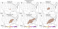
That was quite a lil severe outbreak we had there... don't see that many three body scatter spikes in such a short time in February all that often

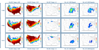
Here's the Birmingham sounding for what it's worth... very straight speed shear hodo supporting robust splits but not too strong to push the hailstones out prematurely, surprisingly good nearly 8°C/km midlevel lapse rates, seasonally impressive CAPE in the hail growth layer aloft; that'll do it

Screenshot 2026-02-26 204527.png
 
Last edited:
Feeling super confident that was a legit tornado even with a <2% risk, the 00z sounding shows enough low level helicity with the modest southerly advection flow to get a brief low level meso... not a lot of helicity but it's there, especially with that cell turning to hard to the right and absorbing several other cells. Certainly some small scale influences with cell mergers just prior to that could have helped
 
Feeling super confident that was a legit tornado even with a <2% risk, the 00z sounding shows enough low level helicity with the modest southerly advection flow to get a brief low level meso... not a lot of helicity but it's there, especially with that cell turning to hard to the right and absorbing several other cells. Certainly some small scale influences with cell mergers just prior to that could have helped

Assuming this is about the Spann comment, it's kinda funny because everyone I've seen on twitter disagrees with him. I don't think I've ever seen a gustnado not only condense but also deal low end damage to several structures...
 
Assuming this is about the Spann comment, it's kinda funny because everyone I've seen on twitter disagrees with him. I don't think I've ever seen a gustnado not only condense but also deal low end damage to several structures...
Aside from that, I don't think I've ever seen someone disagree with Spann on anything. Bad calls happen, though, and it is so ambiguous that I don't blame him.
 
Yesterday was impressive for hail ad the amount of discrete cells that fired. It just makes you realise how lucky we are that high end parameter spaces don't interact with enough forcing and spacing like we seen yesterday to promote long lived supercells all that often.

Regarding the gustnado situation, i wonder if Spann was reluctant due to the lack of a tornado risk yesterday? And he didn't want to jump the gun? Still interesting wording as it was clearly a weak tornado.

Sometimes on these type of days where tornadoes are missed, offices either realise and correct the mistake. OR they do this..

Either way, it looks like a swirling and damaging column of air to me so hopefully we see a survey from it. The hail swathes were interesting too.

That 00z BMX sounding perfectly explains why. Strong CAPE above the HGZ layer, steep lapse rates, and favorable hodograph for a weak tornado/dominant hail threat.
 

Attachments

  • 04a96w37ekp61.jpg
    04a96w37ekp61.jpg
    206.5 KB · Views: 0
Yesterday was impressive for hail ad the amount of discrete cells that fired. It just makes you realise how lucky we are that high end parameter spaces don't interact with enough forcing and spacing like we seen yesterday to promote long lived supercells all that often.

Regarding the gustnado situation, i wonder if Spann was reluctant due to the lack of a tornado risk yesterday? And he didn't want to jump the gun? Still interesting wording as it was clearly a weak tornado.

Sometimes on these type of days where tornadoes are missed, offices either realise and correct the mistake. OR they do this..

Either way, it looks like a swirling and damaging column of air to me so hopefully we see a survey from it. The hail swathes were interesting too.

That 00z BMX sounding perfectly explains why. Strong CAPE above the HGZ layer, steep lapse rates, and favorable hodograph for a weak tornado/dominant hail threat.

Survey in my neighborhood of my sister for tornado damage today in pinson from that storm.

Two distinct tornado survey areas, one in Trussville and one in pinson I think from what I read
 
*looks at Fort Worth intensely*
i still have no idea how that hook-signature, strong & clear velocity couplet, cc-drop associated tornado was not warned, surveyed or acknowledged. all i can think of is that storm spotter coverage in the urban fort-worth area would've been more aware if there was a tornado than via radar analysis, but at the same time i think anything with that figure should at minimum have a tor possible tag or a radar-indicated warning
 
Pretty much all measures support the idea that March will start active and stay active. Still not too many specific dates and times to talk about yet, although the SPC just delineated that D6 15%, but clearly we could be in for a potentially very rambunctious start to the month.
1772206051167.pngnssl20260227.gif
1772206438281.png1772206467595.png1772206483502.png
 

Attachments

  • 1772206430479.png
    1772206430479.png
    272.9 KB · Views: 0
  • 1772206452512.png
    1772206452512.png
    513.7 KB · Views: 0
i still have no idea how that hook-signature, strong & clear velocity couplet, cc-drop associated tornado was not warned, surveyed or acknowledged. all i can think of is that storm spotter coverage in the urban fort-worth area would've been more aware if there was a tornado than via radar analysis, but at the same time i think anything with that figure should at minimum have a tor possible tag or a radar-indicated warning
There was chasers in Fort Worth as it happened. Still don't know why it wasn't even warned
 
Back
Top