
Navigation
Install the app
How to install the app on iOS
Follow along with the video below to see how to install our site as a web app on your home screen.
Note: This feature may not be available in some browsers.
More options
-
Welcome to TalkWeather! We see you lurking around TalkWeather! Take the extra step and join us today to view attachments, see less ads and maybe even join the discussion. CLICK TO JOIN TALKWEATHER
You are using an out of date browser. It may not display this or other websites correctly.
You should upgrade or use an alternative browser.
You should upgrade or use an alternative browser.
Severe Weather 2026
- Thread starter KevinH
- Start date
akt1985
Member
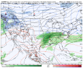
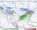
Right now it looks like a lot of rain for a majority of the South on Valentine’s Day. Since models are showing the Low near Nashville next Saturday, is that too far south and east for decent severe weather chances across the Southeast?
The only model that hints at the potential for a more inland severe weather risk is the Euro. Otherwise, the GFS and Canadian would be more of a threat near the Gulf Coast into Florida. At this time, nothing stands out or points towards a more robust severe weather threat.
Attachments
tennessee storm chaser
Member
- Messages
- 1,876
- Reaction score
- 4,283
- Location
- jackson tennessee
- Special Affiliations
- SKYWARN® Volunteer
The 0z gfs came north , SPC new 4 to 8 day outlook now mentions the amplifying trough moving east , will spread deep moisture return into the lower ms valley … interesting see this slp trend more north even as appears be a deeping stronger slp.its showing on ensemblesThe only model that hints at the potential for a more inland severe weather risk is the Euro. Otherwise, the GFS and Canadian would be more of a threat near the Gulf Coast into Florida. At this time, nothing stands out or points towards a more robust severe weather threat.
Last edited:
CheeselandSkies
Member
The 0z gfs came north , SPC new 4 to 8 day outlook now mentions the amplifying trough moving east , will spread deep moisture return into the lower ms valley … interesting see this slp trend more north even as appears be a deeping stronger slp.its showing on ensembles
Interesting that SPC included that wording, but still put days 7 and 8 as "potential too low" on the graphic. They must think the time frame of interest remains just beyond the range of today's outlook.
Kds86z
Member
2 EF0s in Texas the other day.
Kds86z
Member
Way too early to put confidence in it, but that's definitely the look you would want for severe.
tennessee storm chaser
Member
- Messages
- 1,876
- Reaction score
- 4,283
- Location
- jackson tennessee
- Special Affiliations
- SKYWARN® Volunteer
Getting plenty support alsoWay too early to put confidence in it, but that's definitely the look you would want for severe.
Kds86z
Member
I don’t understand?
KakashiHatake2000
Member
its a silly joke going on in the wxtwitter community thats all
Kds86z
Member
Kds86z
Member
Kds86z
Member
Oh boy

Cyclonic Paracosm
Member
checks out pbz afd in the long range now mentions flooding becoming an concern and needs to be watched carefully

N
Not here anymore
Guest
Interesting...


Last edited by a moderator:
tennessee storm chaser
Member
- Messages
- 1,876
- Reaction score
- 4,283
- Location
- jackson tennessee
- Special Affiliations
- SKYWARN® Volunteer
Think SPC starts really hitting on this threat mornings 4 to 8 day outlook
akt1985
Member
Strange, but the models completely drop this system next weekend.
tennessee storm chaser
Member
- Messages
- 1,876
- Reaction score
- 4,283
- Location
- jackson tennessee
- Special Affiliations
- SKYWARN® Volunteer
Think going through that period
Ideas will do that. Then bring it back
Ideas will do that. Then bring it back
Even if we miss the severe weather. Man I'm going to enjoy this warm weather after this bitterly cold spell here in Alabama for the last few weeks