WeathermanLeprechaun
Member
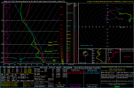
This is old but I meant not guaranteed haha. The sleepiness was on me when typing thisA potentially impactful windstorm may hit me tomorrow morning into the evening if the ICON verifies. The placement of the low determines how intense we may get and imo, 65+ mph wind gusts are looking a decent possibility tomorrow although guaranteed. I am eager to track and document this system, in fact, strong wind gusts are already taking place as i type this comment!
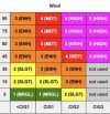
This is in kph, but 103 kph converted to mph is around 70 mph!, the ICON ensembles have had agreement on this which is why I'm concerned. Definitely could see some localised damage and significant flooding. We will see.