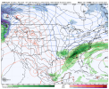
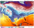
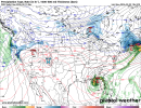
I'm beginning to incorporate some of Cameron Nixon's research into analysing soundings and just for fun, well the 06z GFS explicitly makes it to E IA in this. The Arkansas profiles are absurd for this time of year, 80 0-6km shear and 1k SBCAPE. This is all just for curiosity and this is not to be taken seriously. Lots of variation will occur but some area in Mid Feb may have the potential for a svr event. Just too large of a area to outline atm.
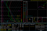
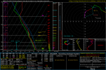
This is taken from Central AR, and basically you want the least water/saturation in your effective inflow layer. You also do want some good dry air aloft, not too much. All in all, that's a nice thermodynamic sounding without considering that nothing actually fires due to that slight warm nose. The general coverage is pretty wild, but thankfully instability response up north is pretty lackluster. The 06z GFS also returns what i called a 1/22/17 all over again just taken per verbatim, and it did it to a p much lesser extent. With a localised area of intense parameters in SE LA.
This sounding is the exact opposite of a good thermodynamic profile and i don't think i have to explain much. While robust low level shear does exist, the EIL is completely saturated and no dry air aloft to compensate for it.
Using this little thermodynamic method, it explains why 3/15/25 underperformed despite being the significant outbreak that it was. The dry air aloft was not as good as initially anticipated and it lead to more messier, struggling storms for the most part. Down south, just a bit more dry air allowed S MS to drop several significant tornadoes. 3/14/25 was actually upper echelon on this method, it was a perfect sounding for healthy supercells.
I just like using these fantasy runs as a little teaching resource/lesson! Hope someone learned something from this!
Central AR sounding 2nd image, SE LA 3rd image