
Navigation
Install the app
How to install the app on iOS
Follow along with the video below to see how to install our site as a web app on your home screen.
Note: This feature may not be available in some browsers.
More options
-
Welcome to TalkWeather! We see you lurking around TalkWeather! Take the extra step and join us today to view attachments, see less ads and maybe even join the discussion. CLICK TO JOIN TALKWEATHER
You are using an out of date browser. It may not display this or other websites correctly.
You should upgrade or use an alternative browser.
You should upgrade or use an alternative browser.
Severe Weather 2026
- Thread starter KevinH
- Start date
Kds86z
Member
Jason Mills
Member
ZDR was close to zero at this time, so definitely seems to be a TDS. 
WeathermanLeprechaun
Member
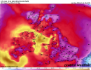
well, the tornado threat may last a bit dependant on line orientation. If this line can sustain in the instability until SE GA, we could be seeing QLCS tor spam for a while. Maybe a little lull atm, but we mightve just had 5+ tornadoes in around that 30 min span
Kds86z
Member
And a new one just popped up..well, the tornado threat may last a bit dependant on line orientation. If this line can sustain in the instability until SE GA, we could be seeing QLCS tor spam for a while. Maybe a little lull atm, but we mightve just had 5+ tornadoes in around that 30 min span
akt1985
Member
The QLCS is about to outrun the Tornado Watch.
Kds86z
Member
Kds86z
Member
WeathermanLeprechaun
Member
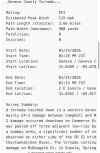
A potentially impactful windstorm may hit me tomorrow morning into the evening if the ICON verifies. The placement of the low determines how intense we may get and imo, 65+ mph wind gusts are looking a decent possibility tomorrow although guaranteed. I am eager to track and document this system, in fact, strong wind gusts are already taking place as i type this comment!
This is in kph, but 103 kph converted to mph is around 70 mph!, the ICON ensembles have had agreement on this which is why I'm concerned. Definitely could see some localised damage and significant flooding. We will see.
This is in kph, but 103 kph converted to mph is around 70 mph!, the ICON ensembles have had agreement on this which is why I'm concerned. Definitely could see some localised damage and significant flooding. We will see.
Attachments
Kds86z
Member
2 Ef1s confirmed from yesterday
Kds86z
Member
WeathermanLeprechaun
Member
Kds86z
Member
- Moderator
- #234
A university chart shouldn't have typos - "midddle." Make me cringe.

Kds86z
Member
I'm just not seeing much if any severe weather increase the next few weeks at present time.
Kds86z
Member
- Thread starter
- #238
KevinH
Member
Yeah I kind of figured the same given how people have not said anything recently. Will be interesting to see how March-May goesI'm just not seeing much if any severe weather increase the next few weeks at present time.

Jason Mills
Member
With intrusion after intrusion of continental polar air, it's going to be very difficult to get any kind of appreciable moisture return for a while. I agree with JPWX - anything major in the severe department seems to be out of the picture for a while.
WeathermanLeprechaun
Member
I don't like the usage of that CIPS probabilistic guidance. It feels more like fuel for chasers just needing to get high on some sort of hope that a good chase is coming soon. No bad words on @Kds86z, he's just sharing and that's no problem.
I just see it used a bit too often in that type of fashion. We'll see
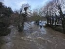
I certainly verified 55-60 mph wind gusts today! Dublin Airport also recorded a 55 mph gust. Could've been worse but those gusts got loud at some points!
I just see it used a bit too often in that type of fashion. We'll see
I certainly verified 55-60 mph wind gusts today! Dublin Airport also recorded a 55 mph gust. Could've been worse but those gusts got loud at some points!