Which is why I really don’t buy the low instability yet that the long range models are depicting. You don’t get a trough and jet presentation like what is being modeled with this more low amplitude and zonal look without some appreciable instability somewhere. If it trends into a more negative tilt, which can make surface cyclogenesis more intense and deepen, that would only serve for a better CAA and WAA response.
Still a ton of model disagreement though as the SPC noted. Model disagreement seems to be the rule now and not the exception lol. I’ve almost gotten to the point where I like the trough and attendant system to come onshore before locking in on geometry and presentation, but the models can still get it right/give clues.
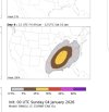
Now, with it being January, there is an instability “ceiling” somewhat due to the sun angles. However, even 1000 k/j of CAPE is sufficient this time of year due to the overwhelming kinematics. We can’t really draw many conclusions on some of the smaller scale details until the medium range models come into view, but this synoptic look is definitely “setting the table”. Which is why MEG mentioned “extreme event”, some of these trough depictions are pretty significant in my opinion.