• Welcome to TalkWeather!
    We see you lurking around TalkWeather! Take the extra step and join us today to view attachments, see less ads and maybe even join the discussion.
    CLICK TO JOIN TALKWEATHER

Severe Weather 2026

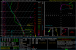
The kinematics should be there. Don't need much in January to get spinups, but you need around 200+ at minimum.

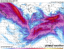
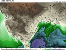
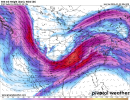
Conditional threat for a low end, brief tornado or two in Central California if any cell can sustain well, and additionally SE Georgia. A few discrete storms have developed and as they go into the rather marginal parameter space with enough low level shear and enough instability considering the morning convection that developed, there may be a low end tornado threat with those too but it is conditional.
 
My gut tells me if those 63+ degree dew points make it more comfortablly up into Tennessee and Kentucky, we'll be in for a very big day across the south.

A trend I've also noticed with temps this Fall/Winter is warm days have been much warmer and cold days have been much colder than originally forecast. We had a day last week where the 24 hour forecast was a brief high of 37, and it ended up making it all the way up to 49 degrees all day. This feels like an indicator of volatility to me.

Does anyone have the parameters of the December 2021 outbreak on hand? Just so we have a good measuring stick of what a large winter outbreak looks like.
I’d argue 12/28 last year, even with it being confined to the coast and a different synoptic look, is a good measuring stick for a “large winter outbreak”.

12/10 is nearly anomalous. A warm sector like we saw on 12/10 would be very impressive for early spring, let alone early December.
 
My gut tells me if those 63+ degree dew points make it more comfortablly up into Tennessee and Kentucky, we'll be in for a very big day across the south.

A trend I've also noticed with temps this Fall/Winter is warm days have been much warmer and cold days have been much colder than originally forecast. We had a day last week where the 24 hour forecast was a brief high of 37, and it ended up making it all the way up to 49 degrees all day. This feels like an indicator of volatility to me.

Does anyone have the parameters of the December 2021 outbreak on hand? Just so we have a good measuring stick of what a large winter outbreak looks like.
Sorry forgot to answer your question. The HREF page on the SPC, SPC event review page and archive should let you view the parameters and Synoptics from that day.

Trey uses those tools often in his videos.


Was really having a hard time figuring out why the models (even the one pictured in the Xpost) are depicting such paltry instability despite pretty rich and deep moisture for the time of year, and now on top of that a negatively-tilted trough that ought to be able to advect in cooler air at the mid-levels.

By looking at the "Cloud Cover" product on the ECMWF-AIFS, I may have found the culprit...it shows the warm sector more than 95% socked in pretty much across the board.

However, with the synoptic pattern as such and the moisture in place, it wouldn't take much destabilization for something to happen. Not calling for anything on that scale yet, but this is one of the reasons 3/14/25 was as significant as it was.
 
It's hard to deny the similarities synoptically and in terms of moisture return here like 12/9/23 and 12/10/21. Moisture return like this we were seeing two weeks ago but we had nothing using it due to a few issues such as too warm at 700 mb and consistent capping/lack of forcing. This event has forcing, and if this warm sector is as extensive as some model scenarios say, i think we'll need to watch this closely. Concerns are slightly rising, given how this warm sector looks. Large warm sectors like this spatially will help cells in longevity. Longevity is what cells need. That's maybe reading too far into it, given we're not at that area of the event yet but a key thing for this event will be the moisture if it holds. IF is the important question.
 
I’d argue 12/28 last year, even with it being confined to the coast and a different synoptic look, is a good measuring stick for a “large winter outbreak”.

12/10 is nearly anomalous. A warm sector like we saw on 12/10 would be very impressive for early spring, let alone early December.
The reason the high risk wasn't pulled that day is because it was so anomalous to even be seeing such moisture return and a volatile environment. They were in uncharted waters and just didn't know what to expect but they didn't want to jump the boat either. Really don't know if we'll ever see one December day like it again
 
MEG Memphis Nws already sound little aggressive to be this far out . Guess time for me to wake up and start model watching starting off with tonight’s 0z runs
MEG being bullish this far out is quite surprising itself. But I really don’t like the way this looks right now. While the instability isn’t very impressive between models at the moment, the hodographs I’m seeing are really nasty. It’s very possible that the instability uptrends too as we get closer. Hoping for downtrends on the 00z runs.
 
If instability surges and uptrends, watch out. THIS hodograph is what you're working with. Any discrete storm in this with a adequate balance of thermodynamic/kinematics will run miles with it. Haven't seen these hodos since Enderlin day, that type of robust LLJ in play here.
 

Attachments

  • 2026010318_GFS_141_35.12,-90.91_winter_mu.png
    2026010318_GFS_141_35.12,-90.91_winter_mu.png
    100.5 KB · Views: 0
View attachment 49539

"Potential for an extreme event" is some strong language for sure. Tennessee is definitely no stranger to December/January strong tornadoes. 2021 is just one example.
Jeez, extreme event? That is very high end wording being honest. Getting a bit uneasy now, this system NEEDS to be watched.
 
This is easily the strongest language I’ve heard since the May 16th event. Very ominous.
Absolutely agree and it's not comforting coming from a office that has seen many significant events in their area. One GFS run had 1k SBCAPE a bit back. I'm wondering if that thermodynamic scenario could pair with the kinematics here. If so, we've got a problem on our hands.
 
The 00z, while not to be taken at face value several days out, takes a step back from the large-scale compact trough depicted in earlier 18z and back runs. It depicts it as an embedded shortwave within the longwave trough rather than an ejecting longwave trough, with a separate area of low pressure forming in the upper plains, northwest of the low-pressure system responsible for the potential for severe weather. Also, dew points are more confined to the south than in earlier runs. To reiterate, only one 00z run, so you may want to hold your cards.
 

Attachments

  • 500wh.conus (1).png
    500wh.conus (1).png
    776.1 KB · Views: 0
  • 500wh.conus.png
    500wh.conus.png
    800.5 KB · Views: 0
  • sfctd-imp.conus (1).png
    sfctd-imp.conus (1).png
    513.8 KB · Views: 0
  • sfctd-imp.conus.png
    sfctd-imp.conus.png
    531.2 KB · Views: 0
MEG being bullish this far out is quite surprising itself. But I really don’t like the way this looks right now. While the instability isn’t very impressive between models at the moment, the hodographs I’m seeing are really nasty. It’s very possible that the instability uptrends too as we get closer. Hoping for downtrends on the 00z runs.
Granted, global models generally struggle with instability in the cold season, tending to do poorly with depicting the subtle, and often meager but critical low-level instability that often propels Deep South wintertime events. It's continuing to show fairly consistent and robust moisture return over the Southeast, so that's cause for concern for me.
trend-gfs-2026010400-f144.sfctd-imp.conus.gif
 
Back
Top