• Welcome to TalkWeather!
    We see you lurking around TalkWeather! Take the extra step and join us today to view attachments, see less ads and maybe even join the discussion.
    CLICK TO JOIN TALKWEATHER

Severe Weather 2026

For those who are interested, here's the link to my weather station:
https://www.wunderground.com/dashboard/pws/KMSSMITH17

I have no idea why wunderground says it's offline when it is. I had trouble getting it to even connect to Wunderground. Anyways, there it is.
 
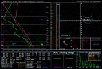
Taking that run for verbatim, it would probably be QLCS spam given shear vectors aren't exactly great to support a discrete mode. But that is vigorous low level shear at play throughout the 8th and 9th. 70/60 in Southern IN is pretty decent.

A lot of people tend to forget you don't need instability this time of year to get tornadoes. That run would have 700 SBCAPE and even then, I'd still say you'd get several, low end tornadoes from a broken line/a line. Still a sign something awaits the 8th/9th. Given how our recent Illinois outbreak uptrended rapidly thermodynamically, i would also anticipate potential uptrends in CAPE as we get closer. That seems to be the major reason many winter events overperform. Do not underestimate this system if it manages t hold like this, can still get some solid activity, these events can be more impactful in some cases.

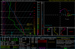
Additionally, for my final little talk, line orientation is VERY important in QLCS events. If you watched Trey'e recent video, 4/28/25 had MANY issues. A neutral jet, but additionally since the propagation of the line caused a more linear look, the line was not orientated compared to your hodographs. This is why the northern portion was the only area of activity and the southern dealt with a lot of outflow.
 

I took a look at a sounding from this event. It doesn't necessarily surprise me using a method I'm working on to further predict significant tornado events and just in general, tornadic events. Some slight curvature, 3CAPE and nearly 1k SBCAPE.
 

Attachments

  • hrrr_2026010118_002_31.75--110.18.png
    hrrr_2026010118_002_31.75--110.18.png
    239.2 KB · Views: 0
I took a look at a sounding from this event. It doesn't necessarily surprise me using a method I'm working on to further predict significant tornado events and just in general, tornadic events. Some slight curvature, 3CAPE and nearly 1k SBCAPE.

BTW @WeathermanLeprechaun, I suppose it would be presumptuous of me to assume you're into this sort of music, but this band came to my hometown about a year and a half ago and I was very excited to go see them!

 
That concert was a definite highlight of my 2024 after chasing in Iowa on April 16th/26th AND May 21st and somehow not seeing a tornado.
I don't blame you for not seeing a tornado on 5/21, those storms were fast moving and tough to keep i with. You just need to go with your gut on some of these days, especially 4/26. There were plenty of tornadoes that day, just depended which target you picked.
 
I don't blame you for not seeing a tornado on 5/21, those storms were fast moving and tough to keep i with. You just need to go with your gut on some of these days, especially 4/26. There were plenty of tornadoes that day, just depended which target you picked.

I targeted fairly well, but let my chosen storm get away from me in the zig-zagging, hill and tree-ridden back roads of southwest/south-central Iowa before it was ready to produce (the 26-minute, 14-mile EF2 that passed near Afton, IA) and then stubbornly stuck to it when I could have easily broken off and gotten a tornado on another storm (either the Mt. Ayer eggbeater multivortex EF1, or the *second* Afton EF2). At the point I called off the chase on US 169 near East Peru, IA at dusk, I was literally surrounded by tornado-warned couplets in three out of four directions but couldn't see anything on any of them, so at that point I considered it an exercise in not getting run over.


This experience actually informed my decision to NOT target that same general part of Iowa (US-34 corridor SW of Des Moines) on May 21st, when it also ended up being where all the significant tornadoes occurred.
 
Anyways, back on topic. 18Z GFS is out and holds serve with the general idea of a big trough ejection in about a weeks' time, with the usual wintertime thermodynamic caveats. As was noted earlier there is something of a tendency to a positive tilt ejection, but on this run it's at least fairly subtle and could be compensated for by the broad E-W wavelength and winds within the jet streak intensifying with time (another OMEGA calculation touched on in Trey's recent 4/28 video); to >115kt at 500mb over parts of MO/IL by 21Z Friday 1/9.
 
It's a decent thing a stout 700 mb warm nose exists tonight in Mississippi. Otherwise, we would be dealing with discrete cells in pretty strong low level shear.. That warm nose has saved us this winter, it's been unusually prolific thermodynamically this second season. That streak will end perhaps on the 8th/9th though. Definitely seeming like some sort of svr threat
 

Attachments

  • 2026010218_NAM_003_31.88,-90.91_winter_mu.png
    2026010218_NAM_003_31.88,-90.91_winter_mu.png
    105.3 KB · Views: 0
2 things worth noting about this 8th/9th system. First, trough ejection will be important to keep an eye on. GFS seems to be trending gradually towards a neater and cleaner look, but expect that to change back and then back again at least once between now and then. Second thing is low position & proximity. Modelling places it fairly high up, near or over the Great Lakes. Sometimes, this can cause issues with forcing, though it's no nail-in-the-coffin by any means. QLCS event seems most likely with this current presentation, but again, could change, though that's a pretty typical threat this time of year. Regardless, this period will likely be the start of the 2026 severe season for at least some folks in the eastern half of the US.
1767409164159.png1767409187116.png
 
The 06z GFS, taken for verbatim is a run displaying a linear-perhaps even broken up line that stretches from Mississippi/Alabama all the way up to southern Indiana. There is a slight instability uptrend and QLCS events with instability like 1k+SBCAPE tend to be more efficient in producing tornadoes. There is lesser shear down south with more instability, much more shear up north, less instability. In all, i think it's a interesting threat.
 
...DISCUSSION...
Convective potential appears likely to increase across at least the
South-Central States by late week. Guidance spread remains large
with the handling of a lower-latitude shortwave trough that will
initially be off the southern CA/Baja CA coast on D4/Tuesday.
Non-ECMWF deterministic guidance largely eject this wave quickly
east-northeastward into the southern Great Plains by late
D5/Wednesday night. The ECMWF, EC-AIFS, and AIGFS maintain a slower
and more reasonable scenario of progression through D6/Thursday.
This will probably interact with a modifying warm-moist sector from
the western Gulf, with some severe potential in a portion of the
South-Central States. Spatiotemporal detail differences exist even
among the preferred slower guidance and the majority of GEFS/ECENS
ML probs remain below 15 percent for Thursday.

For the broad upper trough over the West, latest EC-AIFS and the
ECMWF now depict potential of a negative-tilt evolution compared to
prior runs and other guidance. Spread is quite large within the
ECENS for both the AI/non-AI, indicative of a poorly predictable
pattern for shortwave impulses embedded within the broader trough.
But with potential for fast mid-level southwesterlies overlapping
seasonably rich low-level moisture emanating north from the western
Gulf, and some scenarios indicative of cyclogenesis over the central
states, a severe area highlight may eventually be warranted on
D7/Friday.
 
0.73 inches from yesterday with Tempest Weather Station
0.71 inches from yesterday with manual rain gauge
Very close surprisingly
 
Broad trough on the 12Z Euro with a neutral to slight negative tilt at 0Z Friday 1/9. However something seems off, I feel like the surface response should be stronger than depicted with that look upstairs. At that same time the SLP is only at 1000mb and slowly filling, and the LLJ is around 50-60kt which, while not terrible, seems weak for the time of year. That and we still have the pesky inability for some reason for these systems to advect any cooler air at the mid/upper levels, leading to paltry instability despite decent moisture for the time of year.

However, the low does start to deepen again (999mb at 06Z/midnight), so I feel like this one of those setups where you could get a sneaky nocturnal significant tornado or two if a discrete storm can develop and become sustained within a tiny (too small to be resolved on global models ahead of time) "sweet spot" of adequate thermodynamics.
 
Last edited:
Low-end tornado risk possible today in parts of the Coastal Plain. Keep an eye out for one or two sneaky cells this afternoon.
1767463998780.png
In addition, more modelling systems are starting to pick up on the possible threat later next week. Just coming into range on CIPS mid-range guidance and being picked up by CSU's probs. Nothing massive, but they're sniffing it out.
1767464072567.png1767464188636.png
Very interesting changes on the GFS, though things could change. Low placement seems to be trending more to the south, with hints at secondary low formation in some runs, focusing moisture and energy further south, along a wider stretch of the TNV and Southeast. This could produce a larger area of opportunity for severe weather across a stretch from Louisiana into Georgia, though it'd likely undercut the threat further north. Kinematics are still a bit of a question mark, but they'll likely be plentiful for a QLCS scenario. Either way, folks should keep an eye on late next week, as it does seem to be one of the first organized severe threats in a little while here in the CONUS.
trend-gfs-2026010312-f150.prateptype_cat-imp.conus.giftrend-gfs-2026010312-f150.sfctd-imp.conus.giftrend-gfs-2026010312-f150.mucape.conus.giftrend-gfs-2026010312-f150.srh03.conus.gif
 
Back
Top