AJS
Member
Pretty big tornado watch now in effect. Could get pretty interesting in my area during the next couple of hours.
Follow along with the video below to see how to install our site as a web app on your home screen.
Note: This feature may not be available in some browsers.
I think the 2nd round will actually feature a lot more than just NE Alabama. Althogh I think the northwest portion won't see much.The 1st round is SE MS/SW AL, the 2nd round is NE AL/SE TN/NW GA to some extent.
Down to Central AL additionally, that band extends fairly wellI think the 2nd round will actually feature a lot more than just NE Alabama. Althogh I think the northwest portion won't see much.
Definitely warrants watching - if signs continue to point to a notable setup, I think establishing a thread tomorrow morning and migrating whatever D1 discussions for Tuesday are already in here over would be a wise idea.That was all 2% this morning and all of it was under a marginal risk. *IF* things continue to look more favorable, then it could warrant a thread.
Day 2 Convective Outlook
NWS Storm Prediction Center Norman OK
1121 AM CST Mon Nov 24 2025
Valid 251200Z - 261200Z
...THERE IS A SLIGHT RISK OF SEVERE THUNDERSTORMS IN PARTS OF AL AND
EASTERN MS...
...SUMMARY...
Isolated severe storms are likely across parts of the Southeast/Deep
South, mainly from Tuesday morning into early evening. A couple
tornadoes are possible in parts of eastern Mississippi and Alabama.
...Synopsis...
A leading shortwave impulse over the Lower OH and TN Valleys will
dampen as it moves quickly northeast, downstream of an amplifying
shortwave trough across the Upper Midwest. Surface cyclogenesis will
occur over the Upper MS Valley into the Great Lakes, aiding in
sharpening/acceleration of a trailing cold front on Tuesday night in
the Southeast.
...Deep South...
A high shear-low CAPE environment should be present across
southern/central MS into western AL, where remnants of early-morning
supercells may yield a lingering tornado threat beyond 12Z.
Convection should generally weaken into midday, in the wake of the
leading shortwave impulse departing the TN Valley. Diurnal
destabilization should occur following early-day convection, ahead
of the initially slow-moving cold front. With upper 60s surface dew
points nosing north from the central Gulf Coast, even modest
diabatic heating will sustain moderate buoyancy.
Guidance is consistent with suggesting scattered convection
along/ahead of the outflow-modulated cold front during the
afternoon, despite otherwise nebulous large-scale ascent. Deep-layer
wind fields are expected to be subsiding from strong values early,
but likely remaining adequate for semi-discrete supercell
structures. Modest mid-level lapse rates and expected mode may
curtail greater than isolated severe hail/damaging wind threats.
Tornado potential will be dependent on timing of afternoon
convective development and the degree of low-level hodograph
curvature reduction. But there is sufficient signal to warrant a
corridor of level 2-SLGT for the risk of a couple tornadoes from
lingering storms in the mid-morning and afternoon to early evening
redevelopment. Overall severe threat should become marginal by late
evening/overnight, but may persist on a very isolated basis
east/southward in GA to the FL Panhandle.
..Grams.. 11/24/2025


Mergers of sorts. Eastern TX is doing better then i thought it would so far in terms of presentation but not exactly anything producing thankfully (so far)
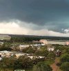
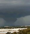
Keep your eye very closely on this, pretty decent CF supercell building up here.Coming right for me!
If it drops, could it be strong?Weird meso handoff occurred but this thing looks even more threatening