tornado examiner
Member
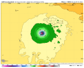
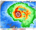
Okay they missed the eye center again, breh.
Follow along with the video below to see how to install our site as a web app on your home screen.
Note: This feature may not be available in some browsers.
Product: Air Force Vortex Message (URNT12 KNHC)
Transmitted: 28th day of the month at 0:01Z
Agency: United States Air Force
Aircraft: Lockheed WC-130J Hercules with reg. number AF96-5301
Storm Name: Melissa
Storm Number & Year: 13 in 2025 (flight in the North Atlantic basin)
Mission Number: 22
Observation Number: 04

A. Time of Center Fix: 27th day of the month at 23:45:00Z
B. Center Fix Coordinates: 16.53N 78.60W
B. Center Fix Location: 157 statute miles (252 km) to the SW (229°) from Kingston, Jamaica.
C. Minimum Height at Standard Level: 2,342m (7,684ft) at 700mb
D. Minimum Sea Level Pressure: 910mb (26.88 inHg)
E. Dropsonde Surface Wind at Center: From 275° at 7kts (From the W at 8mph)
F. Eye Character: Closed
G. Eye Shape & Diameter: Circular with a diameter of 10 nautical miles (12 statute miles)
H. Estimated (by SFMR or visually) Maximum Surface Wind Inbound: 142kts (163.4mph)
I. Location & Time of the Estimated Maximum Surface Wind Inbound: 5 nautical miles to the NE (45°) of center fix at 23:43:30Z
J. Maximum Flight Level Wind Inbound: From 134° at 150kts (From the SE at 172.6mph)
K. Location & Time of the Maximum Flight Level Wind Inbound: 5 nautical miles to the NE (45°) of center fix at 23:43:30Z
L. Estimated (by SFMR or visually) Maximum Surface Wind Outbound: 164kts (188.7mph)
M. Location & Time of the Estimated Maximum Surface Wind Outbound: 6 nautical miles to the SW (226°) of center fix at 23:47:00Z
N. Maximum Flight Level Wind Outbound: From 315° at 156kts (From the NW at 179.5mph)
O. Location & Time of the Maximum Flight Level Wind Outbound: 6 nautical miles to the SW (226°) of center fix at 23:47:00Z
P. Maximum Flight Level Temp & Pressure Altitude Outside Eye: 11°C (52°F) at a pressure alt. of 3,042m (9,980ft)
Q. Maximum Flight Level Temp & Pressure Altitude Inside Eye: 23°C (73°F) at a pressure alt. of 3,051m (10,010ft)
R. Dewpoint Temp (collected at same location as temp inside eye): 12°C (54°F)
R. Sea Surface Temp (collected at same location as temp inside eye): Not Available
S. Fix Determined By: Penetration, Radar, Wind, Pressure and Temperature
S. Fix Levels (surface & flight level centers within 5nm of each other): Surface and 700mb
T. Navigational Fix Accuracy: 0.02 nautical miles
T. Meteorological Accuracy: 1 nautical mile

Remarks Section:

Maximum Flight Level Wind: 156kts (~ 179.5mph) which was observed 6 nautical miles to the SW (226°) from the flight level center at 23:47:00Z
General Note About Vortex Messages:
- SFMR and flight level winds are usually averaged over a 10 second period. (The National Hurricane Center's advisory wind speeds are the highest expected winds averaged over a 1 minute period.)Product: NOAA Temp Drop (Dropsonde) Message (UZNT13 KWBC)
Transmitted: 27th day of the month at 23:58Z
Agency: National Oceanic and Atmospheric Administration (NOAA)
Aircraft: Lockheed WP-3D Orion (Reg. Num. N42RF)
Storm Name: Melissa
Storm Number: 13 (flight in the North Atlantic basin)
Mission Number: 21
Observation Number: 12
Part A...
Date: Near the closest hour of 0Z on the 28th day of the month
Highest Mandatory Level For Which Wind Was Reported: 850mb
Coordinates: 16.6N 78.5W
Location: 149 statute miles (239 km) to the SW (229°) from Kingston, Jamaica.
Marsden Square: 044
Surface and Standard Isobaric Surfaces
Level Geo. Height Air Temp. Dew Point Wind Direction Wind Speed
1000mb This level does not exist in this area of the storm above the surface level.
934mb (27.58 inHg) Surface (Sea Level) 24.6°C (76.3°F) 24.6°C (76°F) 60° (from the ENE) 152 knots (175 mph)
925mb 88m (289 ft) 24.2°C (75.6°F) 24.2°C (76°F) 65° (from the ENE) 168 knots (193 mph)
850mb 829m (2,720 ft) 21.2°C (70.2°F) 21.2°C (70°F) 110° (from the ESE) 147 knots (169 mph)
Information About Radiosonde:
- Launch Time: 23:48Z
- About Sonde: A descending radiosonde tracked automatically by satellite navigation with no solar or infrared correction.
Remarks Section...
Dropsonde Location: Dropped in eyewall 45° (NE) from the eye center.
Highest altitude where wind was reported:
- Location: 16.59N 78.51W
- Time: 23:49:03Z
Lowest altitude where wind was reported:
- Location: 16.63N 78.61W
- Time: 23:51:42Z
Mean Boundary Level Wind (mean wind in the lowest 500 geopotential meters of the sounding):
- Wind Direction: 85° (from the E)
- Wind Speed: 154 knots (177 mph)
Average Wind Over Lowest Available 150 geopotential meters (gpm) of the sounding:
- Lowest 150m: 156 gpm - 6 gpm (512 geo. feet - 20 geo. feet)
- Wind Direction: 70° (from the ENE)
- Wind Speed: 162 knots (186 mph)
Sounding Software Version: AEV 40001
Part B: Data for Significant Levels...
Significant Temperature And Relative Humidity Levels
Level Air Temperature Dew Point
934mb (Surface) 24.6°C (76.3°F) 24.6°C (76°F)
925mb 24.2°C (75.6°F) 24.2°C (76°F)
850mb 21.2°C (70.2°F) 21.2°C (70°F)
753mb 19.0°C (66.2°F) 16.5°C (62°F)
Significant Wind Levels
Level Wind Direction Wind Speed
934mb (Surface) 60° (from the ENE) 152 knots (175 mph)
928mb 65° (from the ENE) 157 knots (181 mph)
923mb 65° (from the ENE) 172 knots (198 mph)
921mb 75° (from the ENE) 168 knots (193 mph)
916mb 80° (from the E) 170 knots (196 mph)
912mb 80° (from the E) 161 knots (185 mph)
909mb 85° (from the E) 162 knots (186 mph)
902mb 95° (from the E) 148 knots (170 mph)
893mb 95° (from the E) 156 knots (180 mph)
886mb 100° (from the E) 149 knots (171 mph)
882mb 100° (from the E) 155 knots (178 mph)
877mb 105° (from the ESE) 149 knots (171 mph)
872mb 105° (from the ESE) 154 knots (177 mph)
850mb 110° (from the ESE) 147 knots (169 mph)
757mb 145° (from the SE) 149 knots (171 mph)
Winds at a particular level are peak winds since a dropsonde only records momentary slices of data at each level as it falls through the atmosphere. These winds are not 1 minute sustained.
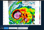
The highest wind observed in the "Significant Wind Levels" section is noted in bold.istg if the jet does that then I don't even know what to do anymore like iif hfas a is seeing the jet interaction, (prob not just model being funny) and thats the outcome then *g u l p*18z HAFS-A is forecasting 200mph, gusts near 220mph, with low of 896mb by 10pm tonight

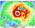
Really starting to remind me of Haiyan with that look, especially with the -80 C CDO.This is the strongest Melissa has looked so far.