
Navigation
Install the app
How to install the app on iOS
Follow along with the video below to see how to install our site as a web app on your home screen.
Note: This feature may not be available in some browsers.
More options
-
Welcome to TalkWeather! We see you lurking around TalkWeather! Take the extra step and join us today to view attachments, see less ads and maybe even join the discussion. CLICK TO JOIN TALKWEATHER
You are using an out of date browser. It may not display this or other websites correctly.
You should upgrade or use an alternative browser.
You should upgrade or use an alternative browser.
Hurricane Melissa
- Thread starter Jacob Aden
- Start date
N0mz
Member
Hurricane warnings up for Cuba now. Forecast to landfall at 125mph.
tornado examiner
Member
This storm is fundamentally broken if it isn't rapidly intensifying now. If recon gets in it, there hasn't been an EWRC cycle. And it still hasn't intensified much. I'm going to be so confused,
majorhurricane1703
Member
I almost wonder if hurricane hunters are delaying in the reporting of the correct information because they don’t want to scare people more.This storm is fundamentally broken if it isn't rapidly intensifying now. If recon gets in it, there hasn't been an EWRC cycle. And it still hasn't intensified much. I'm going to be so confused,
N0mz
Member
AF 53rd just took off from Curacao, home of Ceddanne Rafaela.
slenker
Member
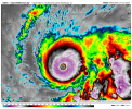
Satellite presentation on this storm just screams Category 5 intensity to me. There’s no way it’s a 145 C4 still, especially with the intensification trends we’re continuing to see.
TornadoFan
Member
So...does the pink mean we're seeing more rapid intensification?

My thoughts exactly. Satellite imagery plus Dvorak all suggest this is a strong category 5 now.Satellite presentation on this storm just screams Category 5 intensity to me. There’s no way it’s a 145 C4 still, especially with the intensification trends we’re continuing to see.
Cyclonic Paracosm
Member

I- wow maybe the best its looked its whole life which is saying something huge ring of -80+ tops around the eye
tornado examiner
Member
Next recon flight just departed I believe. Thank Thor.
Yes. The more pink the color means colder cloud tops leading to more intensification. Pink is not your friendSo...does the pink mean we're seeing more rapid intensification?
View attachment 47972
Yeah, not sure what keeping it at 145 is about. I can definitely see that they might hold off on calling it C5 until pressure goes down a bit more, but I see no reason not to declare the obvious - this is a 5.My thoughts exactly. Satellite imagery plus Dvorak all suggest this is a strong category 5 now.
lake.effect
Member
Upper tier, rare satellite presentation. Only a few storms in history have reached this level on satellite presentation.
tornado examiner
Member
Haiyan. Patricia. Come to mind.Upper tier, rare satellite presentation. Only a few storms in history have reached this level on satellite presentation.
N0mz
Member
Especially in the Caribbean of all placesUpper tier, rare satellite presentation. Only a few storms in history have reached this level on satellite presentation.
Also storms like Melissa is why we need back to back recons. What I mean is have a unmanned drone ready to go as soon as the manned recon gets back to base or something.

joshoctober16
Member
And cloud top readings are down to -91.0 C (or -131.8F)

the -90 temp is form the east blob and not the hurricane.
Cyclonic Paracosm
Member
yeaaah I think mixing may have fixed its self cuz it hasn't looked like this before till now holy heck dudeWhat's remarkable is not just the strength of intensifying convection, but the speed. Core is completely engulfed in deep, intense convection over the course of an hour. Truly an exceptional storm.
View attachment 47974