
Central Ohio Wx
Member
I really can't find any descriptions of the tornado itself, but maybe this could be helpful:Damage pics and or descriptions of the tornado itself


I'll look for damage photos shortly.
Follow along with the video below to see how to install our site as a web app on your home screen.
Note: This feature may not be available in some browsers.
I really can't find any descriptions of the tornado itself, but maybe this could be helpful:Damage pics and or descriptions of the tornado itself
From Fujita's paper on the outbreak:Has anyone ever seen much analysis of the 4/3/1974 tornado near Murphy, North Carolina? This twister allegedly caused extreme forest damage.


WOW! yea that is high end stuff!From Fujita's paper on the outbreak:
View attachment 47615
From his downburst identification book:
View attachment 47616
From his memoirs:
View attachment 47617
I don't doubt it. Some of those Phil Campbell and Tuscaloosa videos are insane. Some notable ones I've seen:It is believed that 7 people died trying to shoot tornado videos on April 27th 2011.
(James Spann April 3rd 2025)
Could someone link to some of these? ThanksI don't doubt it. Some of those Phil Campbell and Tuscaloosa videos are insane. Some notable ones I've seen:
etc.
- Less than 2 miles from Rainsville, with kids, in a car
- The one "Phil Campbell to 911" video
- Taping Smithville from a window as it came through their backyard
- The second-floor Cordova video; the person taping the video sustained serious injuries

Yea man hearing that Spann say that made me again realize the serious nature of the that day.I don't doubt it. Some of those Phil Campbell and Tuscaloosa videos are insane. Some notable ones I've seen:
etc.
- Less than 2 miles from Rainsville, with kids, in a car
- The one "Phil Campbell to 911" video
- Taping Smithville from a window as it came through their backyard
- The second-floor Cordova video; the person taping the video sustained serious injuries
Alright, I think I've figured out how this was deduced via discussion with them; I'll try to replicate this once I get my new computer set up.If you're not going to post any of the fundamental basis - like formulae and mechanisms - as to how he's coming to these conclusions, then I'm not going to give them much credence.


yeah im referring to forward speed. its forward speed over the cycloidals was 71 - 72mph. i believe it mightve peaked over 75mph. i wouldnt be able to tell u an average speed too easily because i dont know exactly where it cycled (and what time)I am curious when you say Robinson was moving faster. Are you referring to forward speed? What was the forward speed of the Robinson tornado?
interestingly, there is some debate over whether it should be rated F5. the tornado is listed in the NCEI database as an F4, and most of Fujita's work surrounding the super outbreak ranks this tornado as an F4. However, later in his life, in his 1994 memoire published soon before his death, he lists the tornado as an F5. Fujita's described the tornado as "leaving behind the largest number of debarked, shiny trees [in the entire superoutbreak]" here is a few photos ive found from it.Has anyone ever seen much analysis of the 4/3/1974 tornado near Murphy, North Carolina? This twister allegedly caused extreme forest damage.


Wow! I have not heard about this particular tornado before much less the extreme forward speed. The photos you posted remind me of some of the ground scouring from I believe it was the Mayfield tornado. It was right when in crossed into Missouri. There is a video of it.yeah im referring to forward speed. its forward speed over the cycloidals was 71 - 72mph. i believe it mightve peaked over 75mph. i wouldnt be able to tell u an average speed too easily because i dont know exactly where it cycled (and what time)
Actually I am mistaken it was in Kentucky. Here is the YouTube video.Wow! I have not heard about this particular tornado before much less the extreme forward speed. The photos you posted remind me of some of the ground scouring from I believe it was the Mayfield tornado. It was right when in crossed into Missouri. There is a video of it.
Actually I am mistaken it was in Kentucky. Here is the YouTube video.
its a very interesting case. it also had an undocumented cycle that was also EF5 intensity according to cycloidal markings. a volumetric 3 sec gust of 212mph was calculated seconds after this extreme tree damage.Wow! I have not heard about this particular tornado before much less the extreme forward speed. The photos you posted remind me of some of the ground scouring from I believe it was the Mayfield tornado. It was right when in crossed into Missouri. There is a video of it.


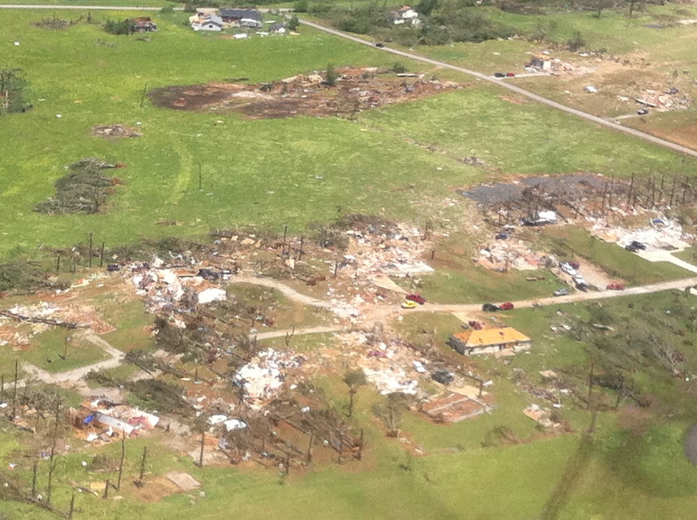
I still kind of wonder why there weren't EF5 ratings applied in Limestone County, some of the damage there was arguably more intense than a lot of the Hackleburg damage.Probable EF5 damage in Tanner from the Hackleburg tornado. Though a damage rating of high-end EF4 was assigned here, multiple homes were swept clean with their debris being wind-rowed up to 300 yards away in some cases. The construction quality of the homes in Tanner was also better than at most other points along the path, with anchor bolts being present at many of the structures per NWS Huntsville. In addition, ground scouring occurred, vehicles were thrown hundreds of yards, and a large shipping container was thrown 600 yards as well.
View attachment 47816
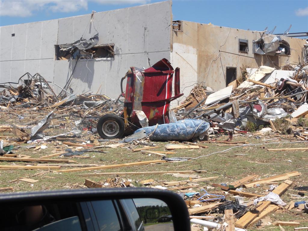
View attachment 47817
From earlier in the path at the Wrangler factory, this was a car apparently. I don't know if that red thing was part of it or not.
I’d honestly say a lot of the survey was highballed. Structures that shouldn’t have been rated higher than low-end EF4 were given EF5 ratings. I’m yet to see a single structure in Hackleburg that actually warrants the EF5 rating, although later down it’s path I think it did hit a few EF5-worthy structures.I still kind of wonder why there weren't EF5 ratings applied in Limestone County, some of the damage there was arguably more intense than a lot of the Hackleburg damage.
Yeah, Hackleburg was a weird survey. Instead of your typical "they lowballed + ignored clear contextual evidence" etc etc they highballed a bunch of houses and gave the wrong ones EF5. The buckled foundation in Mount Hope points to extreme intensity with this thingI still kind of wonder why there weren't EF5 ratings applied in Limestone County, some of the damage there was arguably more intense than a lot of the Hackleburg damage.
Wasn’t there a home in Hackleburg that had concrete stem walls sheared off at something like 2-4 inches AGL? I feel like that may have been the only legitimate home in Hackleburg rated EF5.I’d honestly say a lot of the survey was highballed. Structures that shouldn’t have been rated higher than low-end EF4 were given EF5 ratings. I’m yet to see a single structure in Hackleburg that actually warrants the EF5 rating, although later down it’s path I think it did hit a few EF5-worthy structures.