
Would definitely have better and deeper moisture fetch with that wind direction (South to North) with that Euro run
Navigation
Install the app
How to install the app on iOS
Follow along with the video below to see how to install our site as a web app on your home screen.
Note: This feature may not be available in some browsers.
More options
-
Welcome to TalkWeather! We see you lurking around TalkWeather! Take the extra step and join us today to view attachments, see less ads and maybe even join the discussion. CLICK TO JOIN TALKWEATHER
You are using an out of date browser. It may not display this or other websites correctly.
You should upgrade or use an alternative browser.
You should upgrade or use an alternative browser.
Severe Weather 2025
- Thread starter KevinH
- Start date
warneagle
Member

akt1985
Member
There is a non-zero chance of severe thunderstorms late Saturday night across Alabama. That would not be good for those returning home from Tuscaloosa for the big UT/Bama game.
Kds86z
Member
akt1985
Member
There is a Severe Thunderstorm Watch out this morning for metro Los Angeles.
- Moderator
- #7,006
Area hasn't changed.

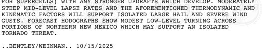
...DISCUSSION...
...Friday/Day 4 and Saturday/Day 5...
A large-scale mid-level trough, and an associated cold front are
forecast to move across the central U.S. on Friday and Saturday.
Isolated to scattered thunderstorms are expected to develop from
late Friday afternoon into the evening along and ahead of the front
from the southern Plains northeastward into the lower to mid
Missouri Valley. Ahead of much of the front, MLCAPE is forecast to
peak around 1000 J/kg with 0-6 km shear ranging from 30 to 40 knots.
This should be sufficient for an isolated severe threat. Cells with
potential for large hail and severe wind gusts will be possible.
On Saturday, moisture advection is forecast to markedly increase
ahead of the approaching trough, as surface dewpoints increase into
the 60s F over much of the moist sector. In spite of this,
instability will be tempered over parts of the Ozarks by ongoing
convection Saturday morning. The models suggest that an axis of
moderate instability will develop a bit further west by afternoon,
with MLCAPE increasing to the 1500 to 2000 J/kg range, mainly in the
Ark-La-Tex. Thunderstorms that develop along and near the
instability axis should obtain a severe threat. Moderate deep-layer
shear is forecast over much of the moist sector, which will
contribute to a potential for supercells with wind damage, hail and
potentially a tornado threat. Storm mode is still uncertain, and
linear mode could become favored relatively early in the event.
Under this scenario, wind damage would be the most likely of the
three hazards. The severe threat should persist into the overnight
period, as an MCS moves eastward through the lower to mid
Mississippi Valley.
...Sunday/Day 6 to Tuesday/Day 8...
Widespread convection is expected to be ongoing Sunday morning
across the Ohio and Tennessee Valleys southward into the central
Gulf Coast states. This convection, along with abundant cloud cover,
should limit destabilization over much of the moist sector during
the day. In spite of this, an isolated severe threat could develop
in areas where sufficient surface heating takes place, from parts of
northern Florida northward into the southern Appalachians. The
severe threat is expected to diminish across the eastern U.S. on
Monday and Tuesday, as the cold front moves offshore into the
western Atlantic. However, uncertainty is still substantial at this
forecast range.
Severe weather across southern California is a big indicator for severe storms further east.
This is also the first Severe Thunderstorm Watch for Southern California since January 27th, 2008 and also the first Severe Thunderstorm Watch on record in October for the area.
This is also the first Severe Thunderstorm Watch for Southern California since January 27th, 2008 and also the first Severe Thunderstorm Watch on record in October for the area.
Kds86z
Member
Storm mode ey.Area hasn't changed.
View attachment 47273
...DISCUSSION...
...Friday/Day 4 and Saturday/Day 5...
A large-scale mid-level trough, and an associated cold front are
forecast to move across the central U.S. on Friday and Saturday.
Isolated to scattered thunderstorms are expected to develop from
late Friday afternoon into the evening along and ahead of the front
from the southern Plains northeastward into the lower to mid
Missouri Valley. Ahead of much of the front, MLCAPE is forecast to
peak around 1000 J/kg with 0-6 km shear ranging from 30 to 40 knots.
This should be sufficient for an isolated severe threat. Cells with
potential for large hail and severe wind gusts will be possible.
On Saturday, moisture advection is forecast to markedly increase
ahead of the approaching trough, as surface dewpoints increase into
the 60s F over much of the moist sector. In spite of this,
instability will be tempered over parts of the Ozarks by ongoing
convection Saturday morning. The models suggest that an axis of
moderate instability will develop a bit further west by afternoon,
with MLCAPE increasing to the 1500 to 2000 J/kg range, mainly in the
Ark-La-Tex. Thunderstorms that develop along and near the
instability axis should obtain a severe threat. Moderate deep-layer
shear is forecast over much of the moist sector, which will
contribute to a potential for supercells with wind damage, hail and
potentially a tornado threat. Storm mode is still uncertain, and
linear mode could become favored relatively early in the event.
Under this scenario, wind damage would be the most likely of the
three hazards. The severe threat should persist into the overnight
period, as an MCS moves eastward through the lower to mid
Mississippi Valley.
...Sunday/Day 6 to Tuesday/Day 8...
Widespread convection is expected to be ongoing Sunday morning
across the Ohio and Tennessee Valleys southward into the central
Gulf Coast states. This convection, along with abundant cloud cover,
should limit destabilization over much of the moist sector during
the day. In spite of this, an isolated severe threat could develop
in areas where sufficient surface heating takes place, from parts of
northern Florida northward into the southern Appalachians. The
severe threat is expected to diminish across the eastern U.S. on
Monday and Tuesday, as the cold front moves offshore into the
western Atlantic. However, uncertainty is still substantial at this
forecast range.
N0mz
Member
Broyles definitely backed off the tornado wording a little. Big discrepancy in the euro vs the gfs solutions (euro has a much more robust surface low) so I get the uncertainty
Kds86z
Member
Kds86z
Member
Kds86z
Member


Already seeing some chatter on if the storms hold off until late Saturday evening/early Sunday morning, the severe threat would be limited.
Me especially as well as everyone else across the Deep South:
Yeah, we'll see about that.
Me especially as well as everyone else across the Deep South:
Yeah, we'll see about that.
Grand Poo Bah
Member
Yo, am I crazy or are the short term models showing a pretty gnarly tornado threat tomorrow afternoon/evening in New Mexico and Colorado?


The Nam


The RAP


The Nam
The RAP
Instability looks like it may be lacking with eastward extent with this one, in part because the trough matures pretty far east and thus the LLJ doesn't amplify early enough to get deeper moisture return earlier in the day.
Kds86z
Member
Yo, am I crazy or are the short term models showing a pretty gnarly tornado threat tomorrow afternoon/evening in New Mexico and Colorado?
View attachment 47310View attachment 47311
View attachment 47312
The Nam
View attachment 47313View attachment 47314
View attachment 47318
The RAP
View attachment 47315
View attachment 47316
View attachment 47319
Attachments
- Moderator
- #7,019
The area grew and expanded farther east.

...Saturday/Day 4...
A large-scale mid-level trough will move through the Great Plains on
Saturday, with a moist airmass in place across the Ark-La-Tex,
Ozarks and lower Mississippi Valley. Within this airmass, an area
of thunderstorms is likely to be ongoing at the start of the period
across parts of eastern Oklahoma and southwest Missouri. Ahead of
this convection, moisture advection and surface heating will
contribute to a moderately unstable airmass by midday, with
forecasts increasing MLCAPE to around 1500 J/kg across the
Ark-La-Tex. Thunderstorm development appears likely in the early
afternoon over much of Ozarks, where moderate deep-layer shear is
forecast. The ECWMF is forecasting 0-6 km shear in the 40 to 50 knot
range over this part of the moist sector, suggesting a severe threat
will be probable during the afternoon. Wind damage will be possible
with bowing line segments, and low-level shear should be sufficient
for tornadoes. Hail will also be possible, mainly if supercells can
develop. Storm mode still remains uncertain. If the mode goes linear
early in the event, the wind-damage threat could become dominant.
The severe threat should persist through the evening and into the
overnight period, as an MCS moves through the central Gulf Coast
states.
- Moderator
- #7,020
They don't seem impressed with my neck of the woods. Which is fine with me since November will be here soon enough.
...Sunday/Day 5 and Monday/Day 6...
The mid-level trough is forecast to move through the Ohio and
Tennessee Valleys on Sunday, and to the Atlantic Seaboard on Monday.
Ahead of the trough, scattered thunderstorms with an isolated severe
threat will be possible Sunday and Sunday night, with much of the
convection moving offshore into the Atlantic relatively early on
Monday. An isolated severe threat would still be possible closer to
the mid-level low in parts of the Mid-Atlantic Monday afternoon.