- Admin
- #1,041
- Messages
- 2,302
- Reaction score
- 1,911
- Location
- Meridianville, Al
- Special Affiliations
- SKYWARN® Volunteer
I was almost thinking we should do a Humberto / Future Imelda combo thread since they're so intertwined.
Follow along with the video below to see how to install our site as a web app on your home screen.
Note: This feature may not be available in some browsers.
I agree with this, they were intertwined for the next several days at least.I was almost thinking we should do a Humberto / Future Imelda combo thread since they're so intertwined.
Do you want me to add in Humberto to the existing PTC Nine thread then?I was almost thinking we should do a Humberto / Future Imelda combo thread since they're so intertwined.
I agree with this, they were intertwined for the next several days at least.
Do you want me to add in Humberto to the existing PTC Nine thread then?
I agree, this situation is rather unprecedented. I can't recall twin hurricanes with (at least one of them) threatening a U.S. landfall and the binary interaction going on. Both NHC advisories mention the other storm and their interaction, so I think it's warranted.I was going to try and move Imelda posts to the new thread, but so many of them mention Humberto as well.
It would be unprecedented to do this. Let me think on it.
000
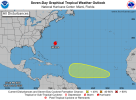
ABNT20 KNHC 012309
TWOAT
Tropical Weather Outlook
NWS National Hurricane Center Miami FL
800 PM EDT Wed Oct 1 2025
For the North Atlantic...Caribbean Sea and the Gulf of America:
Active Systems:
The National Hurricane Center is issuing advisories on Hurricane
Imelda, located less than 150 miles west-southwest of Bermuda.
Central Tropical Atlantic:
A tropical wave is expected to move off the coast of Africa over the
next day or two. Thereafter, this wave is forecast to interact with
another disturbance in the eastern tropical Atlantic, and some slow
development of the combined feature is possible as the system moves
westward to west-northwestward at 15 to 20 mph.
* Formation chance through 48 hours...low...near 0 percent.
* Formation chance through 7 days...low...20 percent.
$$
Forecaster Papin


Things we learned this year:@Wazim Khan @Kds86z @slenker
NUMEROLOGY/LRC/ALMANAC/VEDIC-BASED 2025 ATLANTIC HURRICANE SEASON
Final forecast issued 12 Jun 2025 — no storms formed yet
Metric Forecast Rationale Named Storms (NS) 17 High-octane Gulf & MDR SSTs, but persistent early shear keeps count below hyper-years (2020, 2021). Hurricanes (H) 8 MJO pulse timing, late-starting season, Snake-year “quality over quantity.” Major Hurricanes (MH, Cat ≥ 3) 4 Four numerology red-flag names (Fernand, Humberto, Karen, Melissa) occupy A-tier LRC slots. Category-5 (Cat ≥ 5) 2 Fernand & Humberto sit atop Gulf & CV/Gulf recurver RI windows.
SEASONAL FLOW
Period Character Drivers 10 Jun – 10 Jul Graveyard — SAL, high shear, weak MJO No numerology-charged names yet. 11 Jul – 31 Jul First pulse MJO returns, Gulf moisture surge. 01 Aug – 16 Aug Quiet dip Kelvin wave hiatus. 17 Aug – 16 Sep Main eruption Fernand → Humberto rapid-fire; peak of 25-sum karmic dates (7 Sep). 17 Sep – 02 Oct Transient lull Ridge realigns, Saharan dust burst. 03 Oct – 05 Nov Halloween salvo Karen loop trickery; Melissa Gulf RI; classic Snake-year late bloom. 06 Nov – 30 Nov Hybrid tail Nestor / Olga subtropical ancestry; baroclinic transition corridor.
NAME-BY-NAME FORECAST
(Expression/Soul/Personality numbers shown as Exp–Soul–Per)
# Name Numerology (Exp–S–P) Slot & Timing Peak / Landfall Retirement Odds Key Drivers 1 Andrea 7-7-9 20–28 Jun Campeche gyre 55 kt TS → Tampico 0 % Weak numerology; early-season shear 2 Barry 1-8-2 3–8 Jul SW Gulf 50 kt TS → Padre Is. 0 % Early-July shear, dull numbers 3 Chantal 5-2-3 (dual-3 red flag) 14–22 Jul Gulf 90 kt Cat 2 → Matagorda, TX (OR a flop TS near the CONUS) 15 % First MJO pulse; Snake “trickster” entry 4 Dexter 4-1-3 24–30 Jul open Atlantic 55 kt fish 0 % SAL-ridden MDR; still sheared 5 Erin 1-5-5 5–12 Aug MDR to 50 W 80 kt Cat 1 fish 0 % Weak numerology; no ridge break 6 Fernand 8-6-11(Master 11) 17 Aug – 24 Aug Gulf RI node 145 kt Cat 5 → Freeport/Houston 100 % LRC “Rafael burst”; Venus-Sun dasha; 25-sum warm-eddy 7 Gabrielle 8-2-6 25 Aug – 30 Aug NE Carib 60 kt TS → PR/VI 0 % Snake-year east bend; but shear rises 8 Humberto 3-5-7 06 Sep – 15 Sep CV-Gulf recurver 150 kt Cat 5Bahamas brush → Destin/Pensacola Cat 4-5 100 % Sum-25 date (7 Sep); Milton/Oscar echo; Wood-Snake loop karma 9 Imelda 8-6-11 21 Sep – 26 Sep LA slot 100 kt Cat 3 Houma → inland stall 50 % Master 11 + latent Gulf eddy; flood lineage (2019 Imelda echo) 10 Jerry 4-3-1 28 Sep – 04 Oct 35-45 W 50 kt sub-T fish 0 % Post-Fernand subsidence; baroclinic form 11 Karen 22-6-7(Master 22) 05 Oct – 13 OctBahamas loop 120 kt Cat 4 loop N Bahamas → Big Bend FL Cat 3-4 80 % Betsy-style Snake trick; late-season RI corridor 12 Lorenzo 6-8-7 14 Oct – 22 Oct CV superfish 115 kt Cat 3 mid-Atlantic <10 % Strong numbers but ridge weakness wins 13 Melissa 6-6-9 (triple hit) 25 Oct – 02 NovHalloween Gulf 105 kt Cat 3 → Mobile Bay 70 % 6-6-9 purge + Wood-Snake “final sting” 14 Nestor 1-11-8 06 Nov – 12 Nov SW Gulf 50 kt TS → S. TX 0 % Late shear; frontal interface 15 Olga 8-7-1 13 Nov – 19 Nov SW Caribbean 50 kt TS brush Cuba 0 % Brief RI flirt, then shear kills 16 Pablo 1-7-3 20 Nov – 26 Nov Azores zone 55 kt hybrid 0 % Baroclinic core 17 Rebekah 5-11-3 27 Nov – 03 Dec Gulf Stream 60 kt hybrid, no landfall 0 % Late-season frontal baroclinic 18 Sebastien 2-9-9 Not expected — — Cut by calendar 19 Tanya 2-1-9 Not expected — — Calendar 20 Van 4-1-4 Not expected — — Calendar 21 Wendy 5-5-6 Not expected — — Calendar
Why the Names Stop at Rebekah
- Rebekah’s slot (late-Nov/early-Dec) coincides with seasonal shut-down and neutral numerology.
- No analog or LRC pulse strong enough to sustain another named cyclone once Rebekah exits, so Sebastien, Tanya, Van, Wendy remain unused.
LOGIC SYNTHESIS FOR EACH COLUMN
- Numerology
- 3/6/9 or master 11/22 = “voltage.”
- Fernand (8-6-11) & Humberto (3-5-7) are textbook 9-year killers.
- Karen’s 22 & Melissa’s 6-6-9 lock late-season hair-on-fire majors.
- Climatology
- Very warm Gulf Loop Current eddy, hot Western MDR, La Niña-neutral shear relief after July.
- SAL pulses and Kelvin wave suppressions define lulls.
- Farmer’s Almanac Highlights
- Mid-Aug FL Gulf threat → Fernand timeline.
- Second-week-Sep Atlantic Seaboard threat → Humberto timeline (with Newfoundland tail).
- LRC Slots
- “Rafael burst” (Aug 15-24) and “Milton/Oscar echo” (Sep 6-20) are baked in from the 2024-25 cycle.
- Halloween Gulf echo returns every 51-52 days—in 2025 it aligns with Melissa.
RETIREMENT TALLY
Certain Probable Possible Fernand Karen Imelda Humberto Melissa Chantal
Likely total retired names: 3–4 (Fernand, Humberto, Karen, Melissa).
QUICK “PEAK VS LULL” TIMELINE
scss
Copy
Jun 10–Jul 10 ──────────────── (flatline)
Jul 11–Jul 22 ▲ Chantal spike
Jul 23–Aug 16 ────── (lull)
Aug 17–Aug 24 ▲▲ Fernand burst
Aug 25–Sep 05 ── (brief dip)
Sep 06–Sep 16 ▲▲▲ Humberto peak
Sep 17–Oct 02 ─── (lull)
Oct 03–Oct 13 ▲ Karen loop
Oct 14–Oct 24 ── (brief)
Oct 25–Nov 02 ▲ Melissa Halloween
Nov 03–Nov 30 ──── taper to hybrids
BOTTOM LINE
- Late-starting season but two Cat-5 Gulf monsters (Fernand & Humberto) plus two late majors (Karen & Melissa).
- 17/8/4/2 totals driven by numerology-aligned slots, not by raw storm count obsession.
- Houston & Florida Panhandle remain the bullseyes; east-coast Hugo/Betsy analog stays a low-probability wild card.
Who could have possibly predicted that?Numerology is mostly bunk
Jerry is memeable especially since it is very likely to go OTS
Jerry! Jerry! Jerry!Jerry is memeable especially since it is very likely to go OTS
