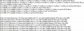
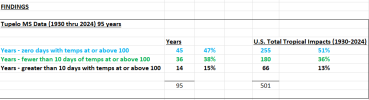
Fun story. I got ChatGPT (I have the paid version) to compile the past several years of mean track errors, based on the NHC verifications, and these are the results:
View attachment 45891
View attachment 45892
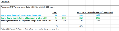
For Cape Verde-type storms specifically:
View attachment 45893
Moral of the story: It is entirely irresponsible for people to be touting this as an OTS storm at this point! We are BEYOND 7 days (closer to 8-10 days), and the models that far out are mostly climatology-driven anyway. It's simply way too soon, and no I'm not wishcasting and wanting a U.S. hit. I'm just saying -- yes, there's a good chance it goes OTS, but also a decent chance it doesn't, and we need to be factual and not comforting erroneously.