• Welcome to TalkWeather!
    We see you lurking around TalkWeather! Take the extra step and join us today to view attachments, see less ads and maybe even join the discussion.
    CLICK TO JOIN TALKWEATHER
  • Current Tropical Systems
    Erin

2025 Atlantic Hurricane Season

I'll preface this by saying I know next to nothing about forecasting hurricanes, but I feel like the models have been strangely consistent about developing a severe hurricane from this wave leaving Africa right now
That’s what worries me. This is my fifth year tracking the Atlantic and I haven’t seen a long tracker there yet.
 
"Africia"

On another note, please god let the orange become Erin so we don't have to lose that particular good name. Many models seem to make the lemon a potentially retireable storm.
What would be coincidental (if our new 0/20 AoI wave becomes Erin) is that we had a Hurricane Erin that struck the east coast of Florida in late July and early August 1995 as a Category 1.
 
That’s what worries me. This is my fifth year tracking the Atlantic and I haven’t seen a long tracker there yet.
Haven’t seen any system as consistent in its depiction of a monster hurricane across all models as I have this one 200+ hours out. Admittedly I’m still a little skeptical on whether or not it’ll become a beast, but the consistency is still definitely worrisome.
 
The consistency in the models this far out is basically unprecedented, I believe. I've been following and tracking hurricanes for almost 30 years (since I was 5 lol), and it's very rare to have this level of pseudo-confidence 10+ days away. The pattern definitely lends itself to a U.S. interaction, although it's much too far in advance to say that explicitly.

And ya know, sometimes you just have a feeling? Well this system definitely has that feeling...


EDIT: Here's the 0z Google DeepMind AI 9 days out --> The red colors are Cat 3, the magenta is Cat 4.


1754744706750.png
 
The consistency in the models this far out is basically unprecedented, I believe. I've been following and tracking hurricanes for almost 30 years (since I was 5 lol), and it's very rare to have this level of pseudo-confidence 10+ days away. The pattern definitely lends itself to a U.S. interaction, although it's much too far in advance to say that explicitly.

And ya know, sometimes you just have a feeling? Well this system definitely has that feeling...
The models have been flipping between OTS, a close shave/scrape of NC or getting into the Gulf so I don’t know what to think right now. The wave already has a decent circulation so it is possible that the GFS was onto something, but the GFS rarely gets a win under its belt.
 
The models have been flipping between OTS, a close shave/scrape of NC or getting into the Gulf so I don’t know what to think right now. The wave already has a decent circulation so it is possible that the GFS was onto something, but the GFS rarely gets a win under its belt.
Yeah, the spread in where the system goes is pretty high right now, but they're pretty certain on a major storm forming. I'm curious when it gets designated Invest (maybe today?), how the hurricane models will handle it. Granted, they only go out 5 days, but we can compare and look at patterns.
 
Yeah, the spread in where the system goes is pretty high right now, but they're pretty certain on a major storm forming. I'm curious when it gets designated Invest (maybe today?), how the hurricane models will handle it. Granted, they only go out 5 days, but we can compare and look at patterns.
I’m expecting 97L as early as this afternoon, maybe tonight or early tomorrow
 
 
The closest thing I’ve seen to the consistency of this across models, in my short ~8 years of watching/tracking hurricanes, was Lee 2023. Models for that were pretty consistent on an extremely intense episode of RI for something like 5-6 days before it occurred. This is further out than that though, and the models are even more consistent. I’m fairly sure we’re going to see a powerful hurricane at this point, the question is where it goes.
 
The 0/40 wave is now Invest 97L so we can now expect the hurricane models to run, so finally we can get a better idea of what the forecast might hold in store for this.
 
If the models trend to a U.S. threat in the next few days I will start to a thread for 97L.
 
The 0/40 wave is now Invest 97L so we can now expect the hurricane models to run, so finally we can get a better idea of what the forecast might hold in store for this.
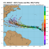
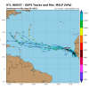
First guidance on 97L and the current track status
IMG_4158.png
IMG_4161.png
 
It does have a large but decent rotation evident on satellite imagery
IMG_4164.jpeg
goes19_ir_97L_202508091305.gif
 
Last edited:
What's going to become paramount with 97L is how the Bermuda high will position itself across the subtropics. The old adage "stronger turns north, weaker goes west" may not hold this time (and it often doesn't hold) if the High is positioned in an orientation that blocks northward movement. I think equally as important as watching 97L's movement and core structure is watching the High and how it may impact this. This is increasingly looking like a high-end scenario, and if it threatens land, it could be quite significant.

EDIT: The HAFS-A and HAFS-B will start running shortly, that will give us a big idea into how this will evolve over the next week.
 
I'm working on developing a short-term ensemble HWRF model, based on the WRF model I made earlier this Spring. I've been *very* busy most of severe weather season and missed most of the times to use the WRF for severe weather, but I'm hoping I can adequately use the HWRF for hurricane season. Since it's run locally (not in the cloud), there's severe limits on what I can do, so it may only have 5-ish members currently, but even that will be useful to see. I may try to move it into a cloud-based platform at some point so it can harness more power. It's more of a toy at the moment, but we'll see what I can manage to do with it lol

EDIT: If I do move it to the cloud, I can probably make it more of a long-term ensemble and have lots of other features. Just thinking.
 
Last edited:
What's going to become paramount with 97L is how the Bermuda high will position itself across the subtropics. The old adage "stronger turns north, weaker goes west" may not hold this time (and it often doesn't hold) if the High is positioned in an orientation that blocks northward movement. I think equally as important as watching 97L's movement and core structure is watching the High and how it may impact this. This is increasingly looking like a high-end scenario, and if it threatens land, it could be quite significant.

EDIT: The HAFS-A and HAFS-B will start running shortly, that will give us a big idea into how this will evolve over the next week.

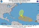
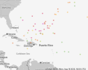
This is my take on this. It is a broad feature, but the fact that it is broad gives me strong reason to believe this will not take off until reaching 60 west. Maybe it is a fish like GFS and the GEFS says that they are, but I think models are initializing development a little too far north in my opinion. Also I think the pull influence created by 96L will be slightly later than what models think. If it travels more west than west northwest even short term (next 2-3 days) that can affect the track greatly later. To me I have a lot of doubts that 96L will become anything. Even if it does I’m not so sure it’s going to be strong enough to where it completely cracks the ridge to create a trough to have enough influence on what could be Erin.


The key is what happens after 60 west. I tend to think the PNA will be more negative supporting a deeper ridge. Florida is less on the table in my view, but the mid Atlantic/northeast not as much.
 
Back
Top