
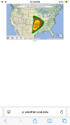
DFW is in the 10% hatched compared to the resent 5%“Higher threat higher than last several days”
Navigation
Install the app
How to install the app on iOS
Follow along with the video below to see how to install our site as a web app on your home screen.
Note: This feature may not be available in some browsers.
More options
-
Welcome to TalkWeather! We see you lurking around TalkWeather! Take the extra step and join us today to view attachments, see less ads and maybe even join the discussion. CLICK TO JOIN TALKWEATHER
You are using an out of date browser. It may not display this or other websites correctly.
You should upgrade or use an alternative browser.
You should upgrade or use an alternative browser.
Severe Weather Threat May 17-19, 2025
- Thread starter Brice W
- Start date
I think that MDT might be expanded a touch southwards to include Collin County.
Kds86z
Member
Kds86z
Member
New day1.
Kds86z
Member
So this setup is interesting because you have a tornado setup early in Eastern OK etc but then later a dryline tornado setup from KS to TX.
AJS
Member
So far, not many reports coming out of the Greensburg supercell area. Could be a really good thing if there’s no damage or a really bad thing if there’s catastrophic damage to farmsteads and houses out in the open.
Kds86z
Member
So far, not many reports coming out of the Greensburg supercell area. Could be a really good thing if there’s no damage or a really bad thing if there’s catastrophic damage to farmsteads and houses out in the open.
Yeah it’s so rural. I am convinced at least some farmsteads and such got slabbed
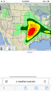
It's possible with the latest graphic from FWDI think that MDT might be expanded a touch southwards to include Collin County.
Schoeppeya
Member
Just insanely rich moisture today with mid 70's dews across Ok.
Kds86z
Member
It's possible with the latest graphic from FWD
Attachments
AJS
Member
I compared the track of the tornado to where it may have gone on maps and it looked to have crossed some areas with farmsteads unfortunately.Yeah it’s so rural. I am convinced at least some farmsteads and such got slabbed
Aaron Rider
Member
That freaky east wind could have helped produce the Spiro, OK tornado of 3/26/1976. It is difficult to say without having seen in-depth analysis.Storm mode seems like the biggest issue today (I'm sensing a theme this year.) With that said, if storms can be discrete then we may be in for some more strong to intense tornadoes, especially across eastern OK. ML CAPE is already in excess of 3,000 J/kg across central OK and this looks to only get more impressive as the day goes on and it translates further east.
Something to watch for is storms across extreme eastern OK and west-central AR where the Arkansas River Valley sits. A while back there was some research done in this area that showed low-level shear tends to get enhanced due to winds favoring coming more out of the east and running up the river valley. Local mets used to call it the "freaky east wind."
Ozonelayer
Member

We have some convection near the OKC metro area.
Central Ohio Wx
Member
I'd say this is that huge Bingham tornado if had tracked over more populated areas. Hopefully no farms were directly hit, but that thing was extremely intense.I compared the track of the tornado to where it may have gone on maps and it looked to have crossed some areas with farmsteads unfortunately.
Kds86z
Member
Messaging however is more concerning. I think that the threat is aligned with the FWD offices graphic.Doesn't look like much as changed in the latest update for the DFW area.
AJS
Member
Dang, they expanded the moderate quite a bit into Missouri.
Possible. I think David hit it on the nail when he said today for North/Central TX will be more of a "wait and see"Messaging however is more concerning. I think that the threat is aligned with the FWD offices graphic.
US_Highway15
Member
David Payne is actually less impressed about the tornado threat today than yesterday:
