Yeah that aggregate is almost dark purple.For tomorrow...big probabilities from CSU
I think you'll see atleast a big moderate day 1 for Friday. Some areas for wind damage and some for tornado.
Follow along with the video below to see how to install our site as a web app on your home screen.
Note: This feature may not be available in some browsers.
Yeah that aggregate is almost dark purple.For tomorrow...big probabilities from CSU
Quickly off-topic, but the Convective Chronicles video with Broyles does an amazing job breaking down why they went with the HIGH that day.April 2nd was a very surprising high risk upgrade to a lot of us, including me - I most certainly did not agree with it, but I stood corrected watching that day unfold. The reason they did it was because the SPC has access to a lot of things we do not and the tools they had pointed to a higher end solution than the regular CAM models like the HRRR and NAM were pointing to that day.
Whatever the SPC does is based on a lot more than what we have access to, for the most part.
Yup! That’s where I got that info from. It’s cool that that high risk wouldn’t have been possible in years past and with the recent developments of OMEGA and whatnot, it allowed them to efficiently forecast a very sneaky day that ended up verifying well into the high risk range.Quickly off-topic, but the Convective Chronicles video with Broyles does an amazing job breaking down why they went with the HIGH that day.
Anyways, yeah, I don't think they're going with a HIGH. MDT, maybe, but unless the SPC knows something we don't (which could very well be true) I don't know if they have enough confidence to go with it.
Yeah I agree. Especially if the day 2 moderate is issues this afternoon.Were the HRRR, RRFS or even to an extent NAM solutions to verify I think we could be looking at a High Risk caliber forecast.
There is obviously a LOT more that goes into the forecast than that, and trying to 'predict' what itself is a prediction is bit futile especially at this range. This is also not me saying I necessarily think one is going to happen.
But were one to be issued, I would not be surprised in the slightest.
The 2021 Naperville EF3 is a great example of that. Besides a field at the very start of its path and a few golf courses here and there, that thing trekked right through residential areas throughout its entire path. It's a miracle nobody died.The HRRR and NAM are now both consistently showing intense helicity tracks over Chicago / central Cook County today. Indicative of several supercells riding the boundary.
NAM has been consistent with this for the past 4 runs. HRRR has been showing this on a few runs but the signal is getting more consistent.
Other than parks, Cook County is 100% developed, highly populated land, if any tornado that drops it will cause substantial damage.
MCS looks to be in the cards for sure. Not sure about discrete activity with the cap in place, but it wouldn't be impossible.What would take this event to the next level for me, is if substantial convection is shown firing in north Mississippi and North Alabama. That would make the scope of this event even bigger imo. Not out of the realm of possibility.
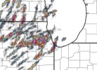
The helicity streak going through southern MO/IL/IN looks eerily reminiscent of the 1925 Tri-State Tornado's path through that general area. Let's hope that a repeat performance is not what ends up happening!View attachment 41576
Yeah seems very well forecasted so far. Nothing that sticks out too much in disagreement honestly. Could maybe see a small moderate around southern Illinois pushing into a small portion of western Kentucky.
The 2021 Naperville EF3 is a great example of that. Besides a field at the very start of its path and a few golf courses here and there, that thing trekked right through residential areas throughout its entire path. It's a miracle nobody died.
For today,?12z hrrr takes a significant deviation from the 06z. Looks like mainly a damaging wind event. I'll toss that one for now lol. See what the next one says
Yeah the 12z is definetly an outlier. Goes from tornado outbreak to possible derecho. My bet is something in between, specifically supercells at first that later form into a squall line somewhere in east central KY/TN.12z hrrr takes a significant deviation from the 06z. Looks like mainly a damaging wind event. I'll toss that one for now lol. See what the next one says