• Welcome to TalkWeather!
    We see you lurking around TalkWeather! Take the extra step and join us today to view attachments, see less ads and maybe even join the discussion.
    CLICK TO JOIN TALKWEATHER

Significant Tornado Events

With all the Palm Sunday 1965 talk in here recently I thought I'd share this post I came across showing WRF proximity soundings from the event. I'm not really sure how this stuff works to be honest (being able to retroactively produce model soundings like this... where does all the data come from? If anyone who knows could chime in, I'd greatly appreciate it).
 
With all the Palm Sunday 1965 talk in here recently I thought I'd share this post I came across showing WRF proximity soundings from the event. I'm not really sure how this stuff works to be honest (being able to retroactively produce model soundings like this... where does all the data come from? If anyone who knows could chime in, I'd greatly appreciate it).

After seeing these soundings, it’s no wonder this day in particular was so incredibly violent. Big arc of perfectly spaced supercells acting upon that environment? That’s a potential super outbreak just waiting to happen.
 
- found a map and images of the radar. This would make the main Yazoo path about 104 miles:


On the topic of VLT tornadoes, what are your opinions on some of the notable ones from before 1976, as well as the newly-analyzed Franklin, AR 119 mile EF4?
In addition to what that guy posted about Yazoo City, I wonder whether there was another break southwest of French Camp where it was apparently quite weak.

I made a post about a year ago on this where I gave my opinion on a list you made. The only near certain 100 mile+ candidate on that list prior to the 2008 Atkins-Highland tornado was the Tri-State tornado. I think this is anomalous and unless the most intense tornadoes have somehow gotten worse, maybe Grazulis was too harsh on his judgements of some older events. It's not entirely impossible for a tornado to greatly weaken then re-strengthen like the Henryville tornado, it just doesn't appear to be very common. The only other candidate I've found so far without strong suggestions it was a family is the 1969 Hazelhurst tornado, though Grazulis gives only 95 miles for this one. I haven't looked at others yet.

I was working on the 2002 Ellettsville-Hartford City tornado when Sentinel Hub was paywalled, so I can no longer the adjust the imagery to get higher contrast. I think it was at least two and maybe as many as four tornadoes. There is a possible path break just north of Martinsville, with a new tornado forming E or SE of Adams. This continues through Greenwood up to near McCordsville, where there may or may not be another break. The next obvious path appears to end at Prosperity, with a gap to a new path starting north of the railway near between Alexandria and Gilman. If anyone has the recent SigTor edition, I'd be interested to see if Grazulis has anything to say.

I've spent some time looking at Sentinel imagery for the March 14 tornado. I'll hold off full judgement until the trees are in full leaf - the 2008 tornado was most obvious at the end of April as the damaged area didn't produce as many leaves. From about Fifty Six to near Franklin the track is quite obvious and wider than the 2008 tornado, but it much less obvious elsewhere so I'd opine it was much weaker in those parts. The DAT photos near Ash Flat show little tree damage, so it might be hard to tell. I see little indication that any tornado crossed the Spring River. In much of the area between Franklin and Ravenden Springs I could be imagining any track, there are possible marks, not all are aligned with anything on DAT.

Past Ravenden Springs I can trace a path as far as the Eleven Point River. From there on I struggle to see anything definite, there are faint suggestions in some places but not always aligned with DAT and I could be linking up unrelated features. Going by the DAT points the tornado must have been broad but weak. The sharp changes of direction near the end of the path seem somewhat atypical for these kinds of fast moving long tracked events - the 2008 tornado was almost dead straight. Overall it could be one track but it could be several, maybe linked by scattered straight line wind damage.

I'll wait to see what later imagery shows, but it's nowhere near as certain at the '08 Atkins-Highland tornado. It just doesn't show up well - the Poplar Bluff tornado is more obvious. I find satellite imagery does have its limitations. Of course it's most useful in forested areas, even strong tornadoes in clear areas can show little unless they produce ground scouring. It's also less useful when the trees are bare. A more thorough examination of the radar could be helpful, but I'm not much good at that.
 
I made a post about a year ago on this where I gave my opinion on a list you made
Y'know what, screw it, I'll take my swing at that list, and your response to it.

Hazlehurst, MS F4 (Mar 29, 1976, 126.5 miles) - Grazulis thinks it may have been up to six tornadoes - Concurred.
Ulysses, KS F2 (May 18, 1977, 117.2 miles) - Grazulis lists a 30 mile F2 as 'the first part of a skipping path' - Concurred.
Wadena, MN F2 (Aug 26, 1977, 110.4 miles) - Grazulis list three F2s, two of which 'skipped' themselves and only total 49 miles, clearly a family - Concurred.
Muscatine, IA F0 (Apr 4, 1981, 103.5 miles) - there are several seperate tornadoes in Storm Data, including a 'mostly skipping' 50 mile. Goodness knows how they all got combined. - Concurred.
Delta, IA F4 (Jun 7, 1984, 134 miles) - Grazulis thinks this one's at least three tornadoes. - Concurred,.
Lawrence, NE F4 (Mar 13, 1990, 131 miles) - probably a family. Storm Data says it was likely at least two tornadoes and apparently Grazulis thinks so too. I'e never seen any suggestions for where the breaks might be though. - Unsure.
Albion, IL F4 (June 1, 1990, 106 miles) - I only have the 1880-1989 version of SigTor so I don't know what Grazulis thinks of this one, though I've never seen it questioned elsewhere. EDIT: the Storm Data entry mentions 'lifting' crossing the Wabash River and 'skipping' in Indiana as far as Hazleton - Concurred, not.a family. Looks like we have at least 3 tornadoes here.
Brandon, MS F4 (Nov 22, 1992, 126 miles) - I'm reluctant to judge the exact path without being able to get the Landsat settings that were on the old viewer, but highly likely it was a family. The offical path has several jinks in it that don't really make sense. - I actually looked at this one on old Google Earth satellite imagery in an attempt to plot out a damage contour, and ended up discovering it was likely at least 7 different tornadoes including multiple ones near Ethel-McCool, and the family never got to Mathiston.
Wilson, NC F3 (Nov 23, 1992, 160 miles) - in Storm Data, the surveyors genuinely think this one's continuous. As quoted on Wikipedia, Grazulis think this one was a family. - No clue. I tried to plot this one out on Google Earth as well to see if it was continuous and could make no determination because it didn't show up on the satellite imagery.
Martinsville-Indianapolis, IN F3 (Sep 20, 2002, 112 miles) - this one's definitely a family. The Storm Data entry for Blackford County says "NWS officials reported the tornado touched down and lifted numerous times along the path" but the one for Delaware County claims it was continuous. I'm quite doubtful of this one. - Concurred. At least 2 tornadoes, maybe even 4. How did we get a "jump-skip" type fake long tracker in *2002*?
Atkins-Clinton, AR EF4 (Feb 5, 2008, 123.5 miles) - apparently this one was confirmed aerially. - Confirmed.
Yazoo City, MS EF4 (Apr 24, 2010, 149 miles) - this one appears to be continuous - Actually, was at least 3 tornadoes, but the main Yazoo track still ran 104 miles.
Hackleburg-Phil Campbell, AL EF5 (Apr 27, 2011, 132 miles) - according to TT it was 103 miles, which matches with how it's plotted in the DAT. - Concurred.
Cordova, AL EF4 (Apr 27, 2011, 127.8 miles) - TT hasn't done a summary yet, but they've written "Cordova EF3/EF4 tornado" which makes me think they think it's either two tornadoes or wasn't an EF4. - This one was continuous. TH2002 was trying to map out the tornado, and couldn't find any damage at one point, but eventually was able to map out the centerline after studying it for about 30 minutes. He couldn't fully rule out a cycle, but Sawmaster pointed out that a cycle was unlikely as it would have had less than 90 seconds to do so. Brian Peters mentioned a possible cycle at this spot, but more likely it was just Cordova doing it's multi-vortex thing. I'm fairly sure the TT thing is because they plan on covering both the morning and afternoon Cordova tornadoes and not because they think the path wasn't continuous.
Enterprise, MS EF4 (Apr 27, 2011, 122 miles) - someone who's not too cheap to pay for the article will know. - This one was continuous.
Mayfield, KY EF4/EF5 (Dec 10, 2021, 166.4 miles) - confirmed - Yep. In fact, it's not out of the question that the full 257 mile track from Arkansas to Kentucky was continuous as well.
Dresden, TN EF3/EF4 (Dec 10, 2021, 122.9 miles) - confirmed

And, as a bonus...

Larkin, AR EF4 (Mar 14, 2025, 118.9 miles) - this one is already under fire, but I trust that LZK wouldn't have combined the tracks if they weren't 100% certain it was a single tornado. I'm fairly certain this was just varying intensity at multiple points.
 
Last edited:
@locomusic01 (sorry for the mention)
Do you have any information on the April 8th-9th, 1919 tornado outbreak?
Not really. It's an event I'd love to dig into at some point but currently all I have are a few crappy pictures from the Whitewright-Mulberry, TX F4:

E2RxmO2.jpeg


yIPJbdD.jpeg


lZ47oxX.jpeg


KhGkGEg.jpeg


5SSjJhS.jpeg


And two others from the Canaan, TX F2:

SCRKemW.jpeg


F7BGhHH.jpeg
 
@locomusic01 (sorry for the mention)
Do you have any information on the April 8th-9th, 1919 tornado outbreak?
Yeah this is an event I'd also like to know more about. If I had to make a modern comparison, it looks like the Eustace/Canton TX event from 4/29/2017 on steroids (and with more tornadoes further west).
 
Yeah, Camp Crook for sure. Not only was it violent, but to put it plainly as possible it should have been rated EF5. Laramie, WY I've also heard may have been violent.


This brings me back to a question I asked in the EF debate thread before The Thing(tm) happened: what are all the F5 candidates from that event? I counted around 13 from my estimate, but I'd like to have a refined number.

Also, as a challenge, what would all of your rating changes be if you reanalyzed the outbreak yourself? (Keep it to the siggies, because I want to see what the OIS for this would be using said rating changes)
I would say at least a high-end EF4.
 
I'll get into some of the other Palm Sunday tornadoes tomorrow, and I know I've posted a lot of these before, but can we just acknowledge once again how baffling it is that this isn't officially in the books as an F5? Most of these photos are from the area around Sunnyside, but also further NE toward Middlebury.

H8nbxKo.jpeg


RBpFeKB.jpeg


4JpIHCB.jpeg


M6KIStE.jpeg


DARdVdU.png


yyMx0Hw.png


g8xIOQs.png


LpcIarC.jpeg
That definitely should be rated F5.
 
Did Fujita assign the original Palm Sunday ratings? And who walked back some of the F5s?
Considering Fujita prepared his reports on that outbreak before the F-scale was introduced I find it highly unlikely he was responsible for the Palm Sunday ratings. From what I've heard, "official" ratings from 1950 up to the introduction of the scale were literally done by college interns looking at damage photos.

Regarding who walked back the initial F5 ratings, I assume it would have been the same people using the same logic as the "well, the homes may have been poorly anchored but we just can't be sure" drivel that was used to keep Worcester at F4.
 
No surprise here. I sometimes wonder if 2021 Mayfield cycled at least once in its life.
Mayfield's 165miles path was 100% continuous confirmed by radar/ damage ground survey/aerial footage/satellite.

It had continuous 3h long TDS signature on radar.
This footage from WXchasing shot damage path from beginning to end and you can see it's a continuous path.

satellite also shows it's one tornado for sure.
SAVE_20250414_103128.jpgSAVE_20250414_103137.jpg
 
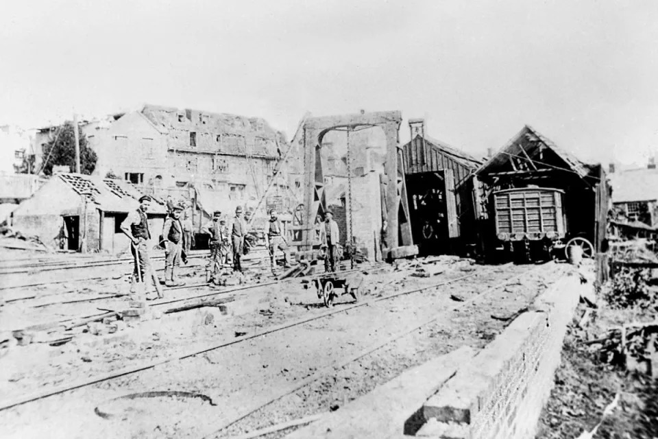
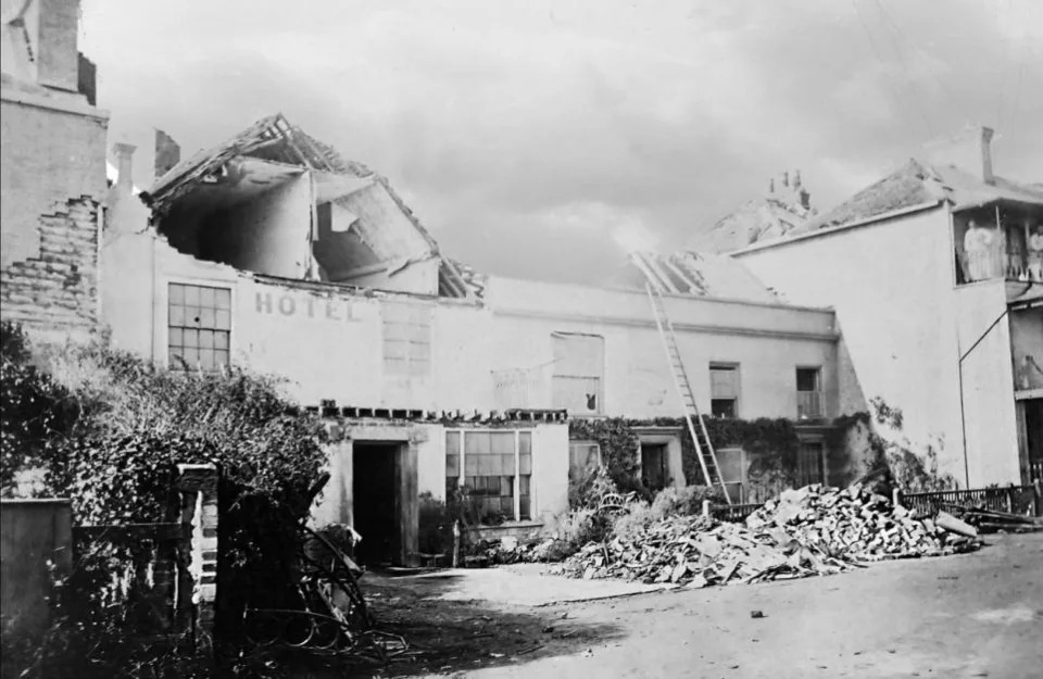
Here's an interesting question that popped into my head: Everyone knows the oldest photo of a tornado was taken in 1884, but what is the oldest photo of tornado damage? For years I thought the 1878 Wallingford tornado fit this bill, but I came across a couple damage photos from the September 28, 1876 Isle of Wight, UK F3 tornado:
5d01b8c33004a766aece8aead7c7c095

da56ed39e022b2c75ae157420b96b4dd


...and an album from the March 10, 1876 Hazel Green, WI F3.

The oldest damage photo I've come across so far is this one from the July 4, 1874 Lewistown, PA tornado:
the-lewistown-bridge-destroyed-by-the-tornado-of-july-4-1874-pennsylvania-640.jpg
Again I am a year and a half late to a thread but I think I have the answer to this question. I have images of damage from a tornado that struck Toronto, Ontario on March 16th, 1868. According to Western University this tornado did F3 damage and tracked over where the CN Tower, Rogers Center and Scotiabank Arena all stand today. The damage in the photo isn’t the craziest and it definitely wasn’t what gave Western University an F3 rating but it is from 1868 and apart from illustrations I cannot find damage from an earlier tornado. If anyone wants anymore info about this tornado I can answer them. TalkWeather won’t let me include the images in my reply so I will try to post them as fast as I can. I am still new to TalkWeather
 
Again I am a year and a half late to a thread but I think I have the answer to this question. I have images of damage from a tornado that struck Toronto, Ontario on March 16th, 1868. According to Western University this tornado did F3 damage and tracked over where the CN Tower, Rogers Center and Scotiabank Arena all stand today. The damage in the photo isn’t the craziest and it definitely wasn’t what gave Western University an F3 rating but it is from 1868 and apart from illustrations I cannot find damage from an earlier tornado. If anyone wants anymore info about this tornado I can answer them. TalkWeather won’t let me include the images in my reply so I will try to post them as fast as I can. I am still new to TalkWeather
I have the photo here and proof that it is from 1868 and was from the Toronto tornado. If this tornado were to happen today thousands of people would be killed as downtown Toronto is extremely densely populated and filled with skyscrapers. I have an image of the path if anyone wants to see that too
 

Attachments

  • IMG_3070.jpeg
    IMG_3070.jpeg
    843.8 KB · Views: 0
  • IMG_3074.jpeg
    IMG_3074.jpeg
    1.2 MB · Views: 0
  • IMG_3075.jpeg
    IMG_3075.jpeg
    1.6 MB · Views: 0
  • IMG_3076.jpeg
    IMG_3076.jpeg
    1.6 MB · Views: 0
I have the photo here and proof that it is from 1868 and was from the Toronto tornado. If this tornado were to happen today thousands of people would be killed as downtown Toronto is extremely densely populated and filled with skyscrapers. I have an image of the path if anyone wants to see that too
Wow, that's an incredible find! I've done previous research on what the earliest known photo of tornado damage could be and came up with the July 4, 1874 Lewistown, PA tornado as a plausible answer - but that photo from Toronto predates it by six years! I'd love to see what more you have from this event.

FWIW, I also found a photo from June 11, 1872 in Lewistown, MO - but I have doubts that event was a legitimate tornado.
 
Back
Top