• Welcome to TalkWeather!
    We see you lurking around TalkWeather! Take the extra step and join us today to view attachments, see less ads and maybe even join the discussion.
    CLICK TO JOIN TALKWEATHER

Severe WX April 1-2 (overnight) Severe Weather Event

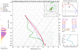
Since i’m still relatively amateur, is this sounding bad?
What you’re seeing here are two different soundings.

The one on the right is the FV3, and the left side is the high resolution (3kmNAM).

The FV3 shows a nicely mixed PBL (likely means that radiative heating caused enough warm moist air to rise) which eroded the CAP and therefore intitiates convection, although the over mixing causes exaggerated updraft sizes which can balloon convective coverage.

Meanwhile the NAM has an over saturated PBL with no mixing to be seen, (which likely means there’s been little in the way of radiative heating/destabilization), and is CAPed all to hell. No convection can hope to trigger in that vertical profile.

When forecasting weather, its best to go with a mean. So I suspect there will be convective initiation, but coverage will be limited, but where ever supercells initiate, those will be capable of producing significant tornadoes.
Ah gotcha. That actually cleared up a lot I needed to know!
 
I think any possible upgrades tomorrow will have to depend on surface obs in the morning and midday. The ingredients are there in OK/S KS and this looks like a pretty classic plains setup. I do think moisture will be a question further north.
Wednesday will go moderate for first update for day 2 in the morning or. The 1230 pm cst update tomorrow
 
Which model handles svr weather the best overall?
There’s no particular single model which is the best overall unfortunately. The hrrr updates hourly so one would think it would have the upper hand, but that’s not the case at all.

In reality every model has its own biases and it’s best to go with a blend to knock out them out.

Meteorologists always use a blend of all available models at their disposal, and most times out of ten their forecast verify.
 
Back
Top