
Navigation
Install the app
How to install the app on iOS
Follow along with the video below to see how to install our site as a web app on your home screen.
Note: This feature may not be available in some browsers.
More options
-
Welcome to TalkWeather! We see you lurking around TalkWeather! Take the extra step and join us today to view attachments, see less ads and maybe even join the discussion. CLICK TO JOIN TALKWEATHER
You are using an out of date browser. It may not display this or other websites correctly.
You should upgrade or use an alternative browser.
You should upgrade or use an alternative browser.
Severe WX April 1-2 (overnight) Severe Weather Event
- Thread starter Bulkshear
- Start date


tennessee storm chaser
Member
- Messages
- 1,877
- Reaction score
- 4,283
- Location
- jackson tennessee
- Special Affiliations
- SKYWARN® Volunteer
I’m working now. , anyone got sounding in western tn area. Memphis areaView attachment 37959
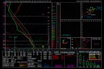
Ludicrous sounding for NE Arkansas. 73/70 temps/dews, very low LCL/LFC, incredible shear, great CAPE, extremely deep moisture and inflow layer. STP of 13 as well.
Curious if that’s slightly convectively contaminated. That’s an insanely deep, saturated moist layer to almost 600 MB for NE Arkansas. Especially for 03Z.View attachment 37959
Ludicrous sounding for NE Arkansas. 73/70 temps/dews, very low LCL/LFC, incredible shear, great CAPE, extremely deep moisture and inflow layer. STP of 13 as well.
CheeselandSkies
Member
Are u planning slipping off down that region cheese?
Possibly; latest NAM just crashed down the forecast environment though.
0Z last night:

12Z this morning:

Pivotalweather.com works on mobile decently well.I’m working now. , anyone got sounding in western tn area. Memphis area
Yeah it seems to be very slightly contaminated, but not enough to do something like that. My general rule of thumb is that a sounding is uncontaminated enough if there aren't any red bars on the left side clipping into the skew-t chart which is the case hereCurious if that’s slightly convectively contaminated. That’s an insanely deep, saturated moist layer to almost 600 MB for NE Arkansas. Especially for 03Z.
That may just be a NAM run-quirk because I’ll be shocked if the moist layer is that deep in NE Arkansas, especially after you factor in some mixing.Yeah it seems to be very slightly contaminated, but not enough to do something like that. My general rule of thumb is that a sounding is uncontaminated enough if there aren't any red bars on the left side clipping into the skew-t chart which is the case here
tennessee storm chaser
Member
- Messages
- 1,877
- Reaction score
- 4,283
- Location
- jackson tennessee
- Special Affiliations
- SKYWARN® Volunteer
Thanx. That area looks have better cape shear over lapPivotalweather.com works on mobile decently well.
It might not be. I checked some other models, and while they do have differences, they are pretty consistent in showing either strong moisture all the way up or a T/Td spread beginning after around 600-700mb.That may just be a NAM run-quirk because I’ll be shocked if the moist layer is that deep in NE Arkansas, especially after you factor in some mixing.
klouzek7079
Member
Here is Memphis metro at 04/03 0zI’m working now. , anyone got sounding in western tn area. Memphis area


wx_guy
Member
- Messages
- 1,237
- Reaction score
- 4,443
- Location
- United States
- HAM Callsign
- KO4ZGH
- Special Affiliations
- SKYWARN® Volunteer
- ARRL Member
I (finally) have a WRF-ARW run of my model going for this threat specifically. It is centered on Jonesboro, Arkansas. I suspect it'll be done between 4 PM and 6 PM, and I'll share the results when it's available.

tornado examiner
Member
It’s funny. March 15th was a kind of similar setup to April 27th 2011 on paper and now Wednesday looks a bit like April 3rd 1974.
Is that weird?
Is that weird?
CheeselandSkies
Member
If the NAM is right, Thursday the 3rd might be equally as dangerous a day for the lower MS Valley/mid-South as Wednesday, if not more so. Another shortwave moves through the broad southwest flow, and this one is actually better-defined then Wednesday's, and doesn't almost completely whiff the warm sector off to the north.
I’ll give you March 15th looked similar to 4/27/11 leading up to the event in a way. However, as we know, it didn’t hit that ceiling.It’s funny. March 15th was a kind of similar setup to April 27th 2011 on paper and now Wednesday looks a bit like April 3rd 1974.
Is that weird?
This one is a bit different than 4/3/74 Synoptics wise. On 4/3/74 you had your main jet core punch directly into the northern part of the warm sector (Indiana, KY, Ohio) and completely overlap it, with a glancing blow to the southern warm sector. If you look at the location of the jet core on Wednesday, it progresses straight over Kansas, up into Iowa, to Michigan. Instead of the warm sector. The low also meanders off into Iowa and Wisconsin.
For bigger severe weather events, I usually like to see that direct punch from the jet core into the warm sector, but that can also be a downside because it means more forcing so more storms.
Also on 4/3/74, the jet, along with some daytime heating helped erode the cap. There’s a possibility with the jet core missing the warm sector on Wednesday, some areas could remain capped for quite a while. You’ll have to rely on mesoscale factors vs some kind of SLP or Jet to lift and cool the cap.
No sir, I do not like it. Now I'm anxious to see the Day 2 outlook tomorrowView attachment 37952
This is a model sounding from north of the DFW metroplex. This event might be very significant.