• Welcome to TalkWeather!
    We see you lurking around TalkWeather! Take the extra step and join us today to view attachments, see less ads and maybe even join the discussion.
    CLICK TO JOIN TALKWEATHER

Severe WX April 1-2 (overnight) Severe Weather Event

Also on 4/3/74, the jet, along with some daytime heating helped erode the cap. There’s a possibility with the jet core missing the warm sector on Wednesday, some areas could remain capped for quite a while. You’ll have to rely on mesoscale factors vs some kind of SLP or Jet to lift and cool the cap.
Cap holds longer it can also worsen the situation. When it does erode
 
I’ll give you March 15th looked similar to 4/27/11 leading up to the event in a way. However, as we know, it didn’t hit that ceiling.

This one is a bit different than 4/3/74 Synoptics wise. On 4/3/74 you had your main jet core punch directly into the northern part of the warm sector (Indiana, KY, Ohio) and completely overlap it, with a glancing blow to the southern warm sector. If you look at the location of the jet core on Wednesday, it progresses straight over Kansas, up into Iowa, to Michigan. Instead of the warm sector. The low also meanders off into Iowa and Wisconsin.

For bigger severe weather events, I usually like to see that direct punch from the jet core into the warm sector, but that can also be a downside because it means more forcing so more storms.
Think also. The super outbreak 74 April was a triple
Phase storm system
 
Cap holds longer it can also worsen the situation. When it does erode
The thing is it’s completely possible it doesn’t erode.

However, that probably won’t be the case since you don’t see many blue sky busts east of the plains since we are so far from the EML source region. I don’t think it will be a very stout EML at all since most of the models show it eventually being eroded, which could mean why the SPC is calling for bowing segments if enough storms go up
 
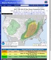
"The Slight Risk has been maintained across parts of OK/TX, but any increase in the signal for storm development along the dryline would necessitate one or more categorical upgrades across this area."

Interesting wording from the latest Day 2 outlook.
Someone said earlier it’s an all or nothing situation tomorrow. This is a really well worded way to reflect that since this area is currently slight risk and they’re implying potentially more than one upgrade. Not sure if that means slight to moderate or upgrades in severe type but either way a potentially dangerous day before the day tomorrow.
 
View attachment 38000
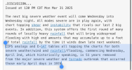
View attachment 38001
No major changes but this is a very serious situation that will mostly likely require an upgrade. Seems like they are only holding off so they can have a more refined moderate area. I would expect that tomorrow morning.
That actually seems pretty bearish. It seems like some of the same flies in the ointment that dampened things yesterday look to occur Wednesday, mainly ongoing convection and unfavorable storm mode.

Will there be tornados? Yes. Will there be storms and severe weather? You bet. So, again, the SPC are doing the right thing.

I haven’t seen anything model wise yet, to indicate any sort of window for long lived, discrete supercells. This seems to be a very wide area severe weather outbreak with different types happening all at once, but without a strong EML, you’re going to have all sorts of showers popping up.

I can see them going moderate for a smallish area, but don’t foresee a high risk at this juncture.
 
That's not really saying this is going to be like the super outbreak though.
Agreed. People who are comparing this to 4/3/74 need to read the outlooks and look at the model data.

The only similarities are big trough, both in early April, and you can have a possible wide range of severe weather over a large area. That’s where the similarities end.
 
That actually seems pretty bearish. It seems like some of the same flies in the ointment that dampened things yesterday look to occur Wednesday, mainly ongoing convection and unfavorable storm mode.

Will there be tornados? Yes. Will there be storms and severe weather? You bet. So, again, the SPC are doing the right thing.

I haven’t seen anything model wise yet, to indicate any sort of window for long lived, discrete supercells. This seems to be a very wide area severe weather outbreak with different types happening all at once, but without a strong EML, you’re going to have all sorts of showers popping up.

I can see them going moderate for a smallish area, but don’t foresee a high risk at this juncture.

Lots of "ifs" in the wording.

Maddeningly, the models haven't really shown us anything new to lend greater confidence one way or the other over the last 24-36 hours, and that goes for the professionals at SPC and double for amateurs like me. Some were asking why this thread has been relatively quiet given the potential teased 3-4 days ago; IMO this is why.
 
That actually seems pretty bearish. It seems like some of the same flies in the ointment that dampened things yesterday look to occur Wednesday, mainly ongoing convection and unfavorable storm mode.

Will there be tornados? Yes. Will there be storms and severe weather? You bet. So, again, the SPC are doing the right thing.

I haven’t seen anything model wise yet, to indicate any sort of window for long lived, discrete supercells. This seems to be a very wide area severe weather outbreak with different types happening all at once, but without a strong EML, you’re going to have all sorts of showers popping up.

I can see them going moderate for a smallish area, but don’t foresee a high risk at this juncture.
Think u see a rather large area moderete risk morning s day 1 update … may not be tornado driven
 
Back
Top