SilentShadow87
Member
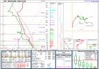
Not 100% sure, but all I can think of isView attachment 36127
Unrelated but this made me laugh. What on earth does this mean?

Follow along with the video below to see how to install our site as a web app on your home screen.
Note: This feature may not be available in some browsers.
Not 100% sure, but all I can think of isView attachment 36127
Unrelated but this made me laugh. What on earth does this mean?
I have the recent scans, thankfully. Have you tried closing down whatever program you're using and/or using a different program (assuming you can)? That could be a potential factor.Is Jackson radar struggling for y'all? Says my most recent scan was 20 minutes ago.
That moisture depth is unreal!Assuming the 16z special from Jackson has been posted (I can't keep up with the fast posting here) - it's quite something, cap is pretty much gone with some steep lapse rates and a very saturated profile; probably explains why so many showers have been able to flood the warm sector
Yet.I'm hoping the forecasted storm potential over Alabama may be over enhanced based on current observations. Not nearly as primed as Mississippi yet.

Not getting anything with both RadarScope (mobile) and GR3 (windows). I have an AllisonHouse sub too.I have the recent scans, thankfully. Have you tried closing down whatever program you/re using and/or using a different program (assuming you can)? That could be a potential factor.
There's definitely something on the ground. I guess the storms are feeling nostalgic today.Tornado reported in Smithville Miss

Get lost, troll.Some of these tornadoes are doing hundreds of dollars of damage in Mississippi

Wow. Still a tad bit of a warm nose. I’m honestly not sure what has caused so much crapvection to go up considering the EML and slight forcing from the broad based trough. The HRRR was signaling it could over convert the warm sector, but that was supercells and not garden variety storms.Assuming the 16z special from Jackson has been posted (I can't keep up with the fast posting here) - it's quite something, cap is pretty much gone with some steep lapse rates and a very saturated profile; probably explains why so many showers have been able to flood the warm sector
I think it will probably be later as the temperatures cool off a little bit and the dewpoints start to rise.Had to step away for a bit, but I presume the 17z HRRR has been discussed? It shows the storms being a lot more discrete than the previous HRRR run that had people thinking the event ceiling might be a lot lower.
Obviously, we can see what is happening on radar in realtime, however, the 17z definitely shows Alabama getting a good batch of discrete supercells.