Smokedevil
Member
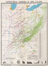
There are very very few places in my areaI think this needs to be said, but in Alabama and Mississippi this Saturday, you should not be chasing tornadoes if your a newbie. This event is dangerous. I hope nobody thinks it'll be cool to storm chase that never has and ends up getting themselves killed because of our terrain or just because of silly mistakes. You should also be figuring out a plan and finding your local storm shelter
( northeast ms) That's "good" to chance in.
A tornado could literally be a 100 yards to your left or right while your driving, and you would NOT see it for all the trees and hills.
45 alternate south of Shannon in Lee and chickasaw county Is a good place. It looks like the delta for several miles.